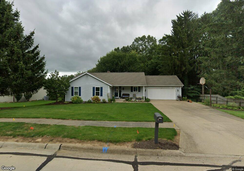
1505 Mcnutt Dr Wooster, OH 44691
Estimated Value: $290,000 - $316,000
3
Beds
3
Baths
1,536
Sq Ft
$198/Sq Ft
Est. Value
About This Home
This home is located at 1505 Mcnutt Dr, Wooster, OH 44691 and is currently estimated at $303,907, approximately $197 per square foot. 1505 Mcnutt Dr is a home located in Wayne County with nearby schools including Melrose Elementary School, Edgewood Middle School, and Wooster High School.
Ownership History
Date
Name
Owned For
Owner Type
Purchase Details
Closed on
Oct 29, 1993
Sold by
Baxstrom Emil
Bought by
Patterson Stephen L and Patterson Eth
Current Estimated Value
Purchase Details
Closed on
Sep 28, 1992
Sold by
Mariola Phillip Special T
Bought by
Baxstrom Emil
Purchase Details
Closed on
May 26, 1992
Sold by
Freeman Barbara I
Bought by
Mariola Phillip Special T
Create a Home Valuation Report for This Property
The Home Valuation Report is an in-depth analysis detailing your home's value as well as a comparison with similar homes in the area
Home Values in the Area
Average Home Value in this Area
Purchase History
| Date | Buyer | Sale Price | Title Company |
|---|---|---|---|
| Patterson Stephen L | $23,000 | -- | |
| Baxstrom Emil | $23,000 | -- | |
| Mariola Phillip Special T | -- | -- |
Source: Public Records
Tax History
| Year | Tax Paid | Tax Assessment Tax Assessment Total Assessment is a certain percentage of the fair market value that is determined by local assessors to be the total taxable value of land and additions on the property. | Land | Improvement |
|---|---|---|---|---|
| 2024 | $3,648 | $98,470 | $19,530 | $78,940 |
| 2023 | $3,677 | $98,470 | $19,530 | $78,940 |
| 2022 | $3,182 | $69,840 | $13,850 | $55,990 |
| 2021 | $3,282 | $69,840 | $13,850 | $55,990 |
| 2020 | $3,112 | $69,840 | $13,850 | $55,990 |
| 2019 | $2,690 | $59,460 | $13,690 | $45,770 |
| 2018 | $2,698 | $59,460 | $13,690 | $45,770 |
| 2017 | $2,707 | $59,460 | $13,690 | $45,770 |
| 2016 | $2,782 | $57,170 | $13,160 | $44,010 |
| 2015 | $2,731 | $57,170 | $13,160 | $44,010 |
| 2014 | $2,733 | $57,170 | $13,160 | $44,010 |
| 2013 | $2,789 | $57,620 | $13,670 | $43,950 |
Source: Public Records
Map
Nearby Homes
- 1552 Renwood Dr
- 1575 Bellevue Dr
- 1774 Hila Way
- 938 Washington St
- 920 Washington St
- 2632 Peach Ln
- 1718 Armadale Isle
- 2630 Bauman Dr
- 1117 Quinby Ave
- 317 Ihrig Ave
- 2208 Cleveland Rd
- 814 N Bever St
- 708 N Bever St
- 211 Oakley Rd
- 216 Ihrig Ave
- 2011 Burbank Rd
- 331 Derr Ave
- 588 Forest Creek Dr
- V/L 6838 Forest Creek Dr
- 2782 Tanglewood Dr
- 1515 Mcnutt Dr
- 1525 Mcnutt Dr
- 1506 Mcnutt Dr
- 1455 Mcnutt Dr
- 1466 Mcnutt Dr
- 1488 Ramblewood Dr
- 1496 Ramblewood Dr
- 1512 Renwood Cir
- 1474 Ramblewood Dr
- 1468 Ramblewood Dr
- 1517 Renwood St
- 1212 Norman Place
- 1530 Mcnutt Dr
- 1518 Renwood Cir
- 1247 Norman Place
- 1538 Ramblewood Dr
- 1456 Ramblewood Dr
- 1435 Mcnutt Dr
- 1336 E Wayne Ave
- 1483 Ramblewood Dr
Your Personal Tour Guide
Ask me questions while you tour the home.