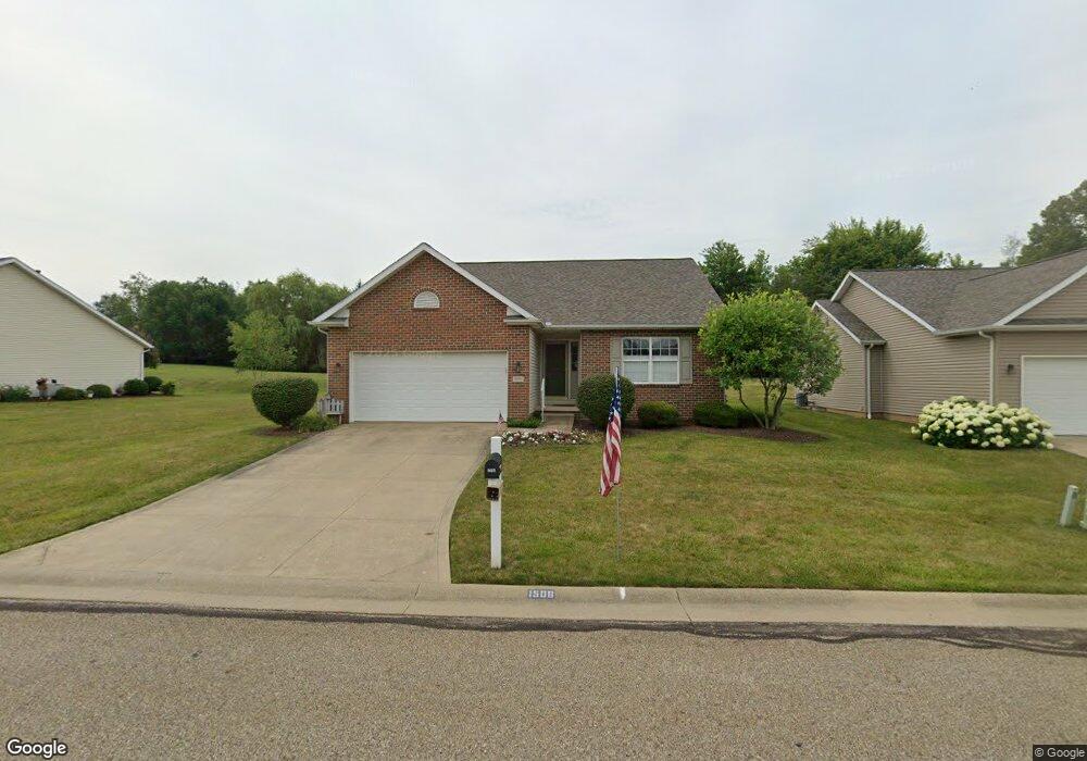
1506 Presidents St Unit 19 Louisville, OH 44641
Estimated Value: $259,416 - $281,000
2
Beds
2
Baths
1,380
Sq Ft
$193/Sq Ft
Est. Value
About This Home
This home is located at 1506 Presidents St Unit 19, Louisville, OH 44641 and is currently estimated at $266,604, approximately $193 per square foot. 1506 Presidents St Unit 19 is a home located in Stark County with nearby schools including Louisville High School and St. Thomas Aquinas High School & Middle School.
Ownership History
Date
Name
Owned For
Owner Type
Purchase Details
Closed on
Jul 30, 2002
Sold by
Miranoma Inc
Bought by
Vernier Gladys L
Current Estimated Value
Home Financials for this Owner
Home Financials are based on the most recent Mortgage that was taken out on this home.
Original Mortgage
$33,240
Interest Rate
5.62%
Create a Home Valuation Report for This Property
The Home Valuation Report is an in-depth analysis detailing your home's value as well as a comparison with similar homes in the area
Home Values in the Area
Average Home Value in this Area
Purchase History
| Date | Buyer | Sale Price | Title Company |
|---|---|---|---|
| Vernier Gladys L | $158,300 | -- |
Source: Public Records
Mortgage History
| Date | Status | Borrower | Loan Amount |
|---|---|---|---|
| Closed | Vernier Gladys L | $33,240 |
Source: Public Records
Tax History Compared to Growth
Tax History
| Year | Tax Paid | Tax Assessment Tax Assessment Total Assessment is a certain percentage of the fair market value that is determined by local assessors to be the total taxable value of land and additions on the property. | Land | Improvement |
|---|---|---|---|---|
| 2025 | -- | $82,330 | $16,210 | $66,120 |
| 2024 | -- | $82,330 | $16,210 | $66,120 |
| 2023 | $2,381 | $64,580 | $12,570 | $52,010 |
| 2022 | $2,405 | $64,580 | $12,570 | $52,010 |
| 2021 | $2,412 | $64,580 | $12,570 | $52,010 |
| 2020 | $1,978 | $58,630 | $11,310 | $47,320 |
| 2019 | $1,992 | $58,630 | $11,310 | $47,320 |
| 2018 | $1,985 | $58,630 | $11,310 | $47,320 |
| 2017 | $1,842 | $53,410 | $10,500 | $42,910 |
| 2016 | $1,880 | $53,410 | $10,500 | $42,910 |
| 2015 | $1,885 | $53,410 | $10,500 | $42,910 |
| 2014 | $1,864 | $49,810 | $11,100 | $38,710 |
| 2013 | $936 | $49,810 | $11,100 | $38,710 |
Source: Public Records
Map
Nearby Homes
- 641 S Nickelplate St
- 1715 High St
- 908 Sand Lot Cir
- 2110 Edmar St
- 1812 E Broad St
- 520 S Silver St
- 728 E Broad St
- 308 Superior St
- 510 S Bauman Ct
- 204 E Broad St
- 3390 Meese Rd NE
- 107 E Broad St
- 0 Michigan Blvd
- 1702 View Pointe Ave
- 1639 Horizon Dr
- 2015 E Main St
- 8225 Georgetown St
- 325 Lincoln Ave
- 1170 Winding Ridge Ave
- 910 Crosswyck Cir
- 1500 Presidents St Unit 18
- Lot 38 Presidents St
- 1516 Presidents St Unit 20
- 1424 Presidents St Unit 17
- 1427 Presidents St Unit 15
- 1522 Presidents St Unit 21
- 1421 Presidents St Unit 14
- 1418 Presidents St Unit 16
- 1528 Presidents St
- 41 Presidents St
- 1506 Edmar St
- 1428 Edmar St
- 1409 Presidents St Unit 12
- 1534 Presidents St Unit 23
- 1418 Edmar St
- 1526 Edmar St
- 1403 Presidents St
- 1330 Presidents St Unit 9
- 1408 Edmar St
- 1536 Edmar St