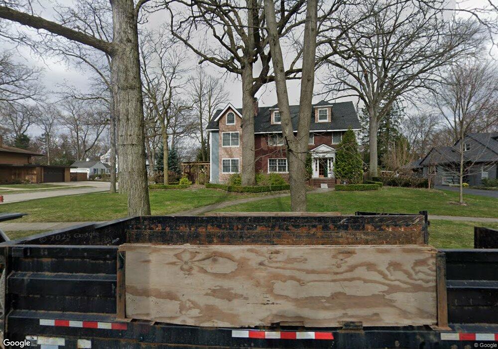
1507 Vinsetta Blvd Royal Oak, MI 48067
Estimated Value: $932,000 - $1,014,000
3
Beds
4
Baths
3,191
Sq Ft
$302/Sq Ft
Est. Value
About This Home
This home is located at 1507 Vinsetta Blvd, Royal Oak, MI 48067 and is currently estimated at $964,417, approximately $302 per square foot. 1507 Vinsetta Blvd is a home located in Oakland County with nearby schools including Northwood Elementary School, Royal Oak Middle School, and Royal Oak High School.
Ownership History
Date
Name
Owned For
Owner Type
Purchase Details
Closed on
Oct 29, 2004
Sold by
Morgenstein Michael L and Morgenstein Kristine M
Bought by
Pickering Daniel J and Pickering Lisa A
Current Estimated Value
Home Financials for this Owner
Home Financials are based on the most recent Mortgage that was taken out on this home.
Original Mortgage
$444,000
Outstanding Balance
$221,866
Interest Rate
5.8%
Mortgage Type
Purchase Money Mortgage
Estimated Equity
$742,551
Purchase Details
Closed on
Jul 30, 1996
Sold by
Petersen Ralph R
Bought by
Morgenstein Michael L
Home Financials for this Owner
Home Financials are based on the most recent Mortgage that was taken out on this home.
Original Mortgage
$252,000
Interest Rate
8.3%
Create a Home Valuation Report for This Property
The Home Valuation Report is an in-depth analysis detailing your home's value as well as a comparison with similar homes in the area
Home Values in the Area
Average Home Value in this Area
Purchase History
| Date | Buyer | Sale Price | Title Company |
|---|---|---|---|
| Pickering Daniel J | $555,000 | Metropolitan Title Company | |
| Morgenstein Michael L | $323,000 | -- |
Source: Public Records
Mortgage History
| Date | Status | Borrower | Loan Amount |
|---|---|---|---|
| Open | Pickering Daniel J | $444,000 | |
| Previous Owner | Morgenstein Michael L | $252,000 |
Source: Public Records
Tax History Compared to Growth
Tax History
| Year | Tax Paid | Tax Assessment Tax Assessment Total Assessment is a certain percentage of the fair market value that is determined by local assessors to be the total taxable value of land and additions on the property. | Land | Improvement |
|---|---|---|---|---|
| 2024 | $10,048 | $435,940 | $0 | $0 |
| 2022 | $11,872 | $403,260 | $0 | $0 |
| 2020 | $9,764 | $360,200 | $0 | $0 |
| 2018 | $11,872 | $183,220 | $0 | $0 |
| 2017 | $6,272 | $183,220 | $0 | $0 |
| 2015 | -- | $169,330 | $0 | $0 |
| 2014 | -- | $165,420 | $0 | $0 |
| 2011 | -- | $144,180 | $0 | $0 |
Source: Public Records
Map
Nearby Homes
- 1630 W 12 Mile Rd
- 1319 Woodsboro Dr
- 1718 W 12 Mile Rd
- 1721 Forestdale Ct
- 1808 W 12 Mile Rd
- 1828 W 12 Mile Rd
- 1103 Fernwood Rd
- 2015 Alicia Ln
- 1022 Maplegrove Ave
- 1402 Catalpa Dr
- 1915 Northwood Blvd
- 1363 Edgewood Blvd
- 820 Oakridge Ave
- 1450 Wiltshire Rd
- 1197 Catalpa Dr
- 934 Lockwood Rd
- 821 Forestdale Rd
- 719 W 12 Mile Rd
- 817 Fernwood Rd
- 2856 Central St
- 1517 Vinsetta Blvd
- 1427 Vinsetta Blvd
- 1624 Woodsboro Dr
- 1525 Vinsetta Blvd
- 1621 Woodsboro Dr
- 1609 Cedarhill Dr
- 1417 Vinsetta Blvd
- 1634 Woodsboro Dr
- 1634 Woodsboro Dr
- 1631 Woodsboro Dr
- 1634 Woodsboro Dr
- 1624 Greenleaf Dr
- 1516 Vinsetta Blvd
- 1504 Vinsetta Blvd
- 1623 Cedarhill Dr
- 1605 Vinsetta Blvd
- 1407 Vinsetta Blvd
- 1703 Woodsboro Dr
- 1704 Woodsboro Dr
- 1602 Cedarhill Dr