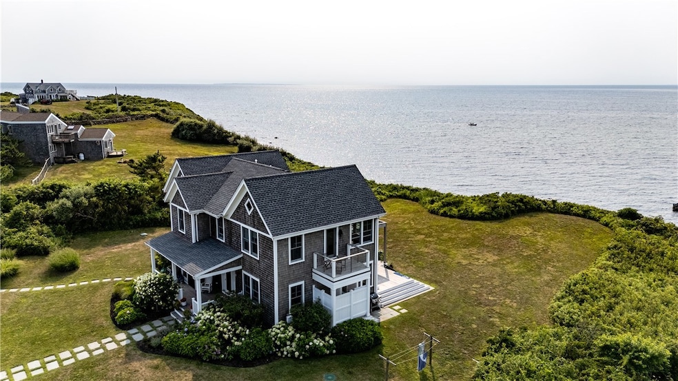
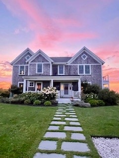
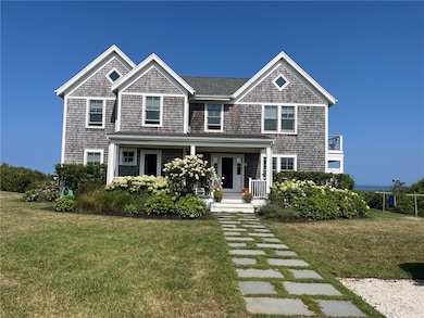
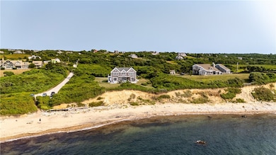


1508 Dories Cove Rd Block Island, RI 02807
Estimated payment $31,679/month
Highlights
- Hot Property
- Water Access
- Wood Flooring
- Beach Front
- Contemporary Architecture
- Attic
About This Home
One of only a handful of true waterfront homes, this exceptional residence sits on a gentle bluff just 50 yards from the beach, offering unobstructed sunset views over the ocean from every one of its four bedrooms as well as the kitchen/living/dining area. Completely reconstructed in 2019 with top-of-the-line finishes, the home features a chef's kitchen designed for entertaining. The spacious oceanside deck with retractable awning has a fire pit, an eating table and outdoor couches. The finished lower level is perfect for indoor fun. Sophisticated yet relaxed, this is a rare opportunity too enjoy breathtaking vista and luxurious coastal living.
Listing Agent
Sullivan Sotheby's Intl.Realty License #REB.0015149 Listed on: 10/17/2025

Home Details
Home Type
- Single Family
Est. Annual Taxes
- $16,478
Year Built
- Built in 2019
Lot Details
- 1.96 Acre Lot
- Beach Front
- Property is zoned RA
Parking
- No Garage
Home Design
- Contemporary Architecture
- Block Foundation
Interior Spaces
- 2-Story Property
- Wet Bar
- Family Room
- Game Room
- Utility Room
- Water Views
- Security System Owned
- Attic
Kitchen
- Oven
- Range with Range Hood
- Microwave
- Dishwasher
Flooring
- Wood
- Ceramic Tile
Bedrooms and Bathrooms
- 4 Bedrooms
- Bathtub with Shower
Laundry
- Laundry Room
- Dryer
- Washer
Partially Finished Basement
- Basement Fills Entire Space Under The House
- Interior and Exterior Basement Entry
Outdoor Features
- Water Access
- Walking Distance to Water
- Outdoor Grill
Utilities
- Forced Air Heating and Cooling System
- Heating System Uses Propane
- 200+ Amp Service
- Private Water Source
- Well
- Tankless Water Heater
- Gas Water Heater
- Septic Tank
Listing and Financial Details
- Tax Lot 046-1
- Assessor Parcel Number 1508DORRY'SCOVERDNSHM
Map
Home Values in the Area
Average Home Value in this Area
Tax History
| Year | Tax Paid | Tax Assessment Tax Assessment Total Assessment is a certain percentage of the fair market value that is determined by local assessors to be the total taxable value of land and additions on the property. | Land | Improvement |
|---|---|---|---|---|
| 2024 | $16,478 | $2,985,200 | $1,707,400 | $1,277,800 |
| 2023 | $17,971 | $2,985,200 | $1,707,400 | $1,277,800 |
| 2022 | $14,347 | $2,026,400 | $1,513,680 | $512,720 |
| 2021 | $13,577 | $2,026,400 | $1,513,680 | $512,720 |
| 2020 | $12,888 | $2,026,400 | $1,513,680 | $512,720 |
| 2019 | $12,483 | $2,026,400 | $1,513,680 | $512,720 |
| 2018 | $11,296 | $1,898,560 | $1,513,680 | $384,880 |
| 2017 | $10,157 | $1,733,280 | $1,513,680 | $219,600 |
| 2016 | $9,914 | $1,733,280 | $1,513,680 | $219,600 |
| 2015 | $11,994 | $2,176,800 | $1,892,100 | $284,700 |
| 2014 | $11,624 | $2,176,800 | $1,892,100 | $284,700 |
| 2013 | $11,341 | $2,176,800 | $1,892,100 | $284,700 |
Property History
| Date | Event | Price | List to Sale | Price per Sq Ft |
|---|---|---|---|---|
| 10/17/2025 10/17/25 | For Sale | $5,750,000 | -- | $1,174 / Sq Ft |
Purchase History
| Date | Type | Sale Price | Title Company |
|---|---|---|---|
| Deed | $2,135,000 | -- |
Mortgage History
| Date | Status | Loan Amount | Loan Type |
|---|---|---|---|
| Closed | $1,459,620 | No Value Available | |
| Closed | $1,459,620 | No Value Available | |
| Closed | $2,000,000 | No Value Available | |
| Closed | $2,135,000 | Purchase Money Mortgage |
Source: State-Wide MLS
MLS Number: 1398185
APN: BLOC-000015-000000-000046-000001
Disclaimer: Certain information contained herein is derived from information provided by parties other than Homes.com. All information provided is deemed reliable, but is not guaranteed to be accurate and should be independently verified.
![]() IDX information is provided exclusively for personal, non-commercial use, and may not be used for any purpose other than to identify prospective properties consumers may be interested in purchasing. Information is deemed reliable but not guaranteed.
IDX information is provided exclusively for personal, non-commercial use, and may not be used for any purpose other than to identify prospective properties consumers may be interested in purchasing. Information is deemed reliable but not guaranteed.
Copyright © 2025 State-Wide MLS, Inc. All rights reserved.
- 1596 W Side Rd
- 1557 W Side Rd
- 899 Cooneymus Rd
- 1210 Graces Cove Rd
- 1501 Beacon Hill Rd
- 0 Coast Guard Rd
- 1328 Cooneymus Rd
- 1194 Center Rd
- 540 Off Center Rd
- 557 Center Rd
- 0 W Side Rd Unit 1376234
- 1087 Lakeside Dr
- 481 Old Town Rd
- 0 Snake Hole Rd
- 1661 Sand Pond Rd
- 1448 Mohegan Trail
- 1035 Mohegan Trail
- 1743 Corn Neck Rd
- 194 Pilot Hill Rd
- 256 High St
- 32 5th Ave
- 32 Shore Dr
- 295 Carpenter Dr
- 20 Wagner Rd
- 33 Breach Dr Unit front
- 790 Green Hill Beach Rd
- 7 Cattail Dr
- 3 Henley St
- 39 Salt Pond Way
- 36 Burnham St
- 38 Langworthy Rd
- 72 Elm Rd
- 11 Tellier Rd
- 57 Sheila Dr
- 13 Valley Dr
- 121 Balsam Rd
- 126 Alder Rd
- 3865 Old Post Rd
- 271 Great Island Rd Unit B
- 41 Atlantic Ave