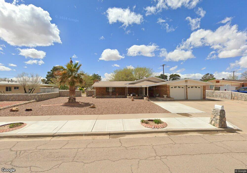
15087 Homestead Dr El Paso, TX 79928
Estimated Value: $270,887 - $329,000
3
Beds
2
Baths
2,194
Sq Ft
$132/Sq Ft
Est. Value
About This Home
This home is located at 15087 Homestead Dr, El Paso, TX 79928 and is currently estimated at $290,472, approximately $132 per square foot. 15087 Homestead Dr is a home located in El Paso County with nearby schools including Horizon Heights Elementary School, Col. John O. Ensor Middle School, and Eastlake High School.
Ownership History
Date
Name
Owned For
Owner Type
Purchase Details
Closed on
Nov 2, 2007
Sold by
Amaya David and Amaya Emilia
Bought by
Childress James Robert and Childress Sandra Irene
Current Estimated Value
Home Financials for this Owner
Home Financials are based on the most recent Mortgage that was taken out on this home.
Original Mortgage
$128,000
Outstanding Balance
$80,945
Interest Rate
6.37%
Mortgage Type
Purchase Money Mortgage
Estimated Equity
$209,527
Purchase Details
Closed on
Jan 30, 1995
Sold by
Schulte Don Park and Schulte Guadalupe
Bought by
Amaya David and Amaya Emilia
Home Financials for this Owner
Home Financials are based on the most recent Mortgage that was taken out on this home.
Original Mortgage
$85,602
Interest Rate
9.13%
Mortgage Type
Seller Take Back
Create a Home Valuation Report for This Property
The Home Valuation Report is an in-depth analysis detailing your home's value as well as a comparison with similar homes in the area
Home Values in the Area
Average Home Value in this Area
Purchase History
| Date | Buyer | Sale Price | Title Company |
|---|---|---|---|
| Childress James Robert | -- | St | |
| Amaya David | -- | -- |
Source: Public Records
Mortgage History
| Date | Status | Borrower | Loan Amount |
|---|---|---|---|
| Open | Childress James Robert | $128,000 | |
| Previous Owner | Amaya David | $85,602 |
Source: Public Records
Tax History Compared to Growth
Tax History
| Year | Tax Paid | Tax Assessment Tax Assessment Total Assessment is a certain percentage of the fair market value that is determined by local assessors to be the total taxable value of land and additions on the property. | Land | Improvement |
|---|---|---|---|---|
| 2025 | $4,153 | $226,274 | -- | -- |
| 2024 | $4,153 | $205,704 | -- | -- |
| 2023 | $3,660 | $187,004 | $0 | $0 |
| 2022 | $5,388 | $170,004 | $0 | $0 |
| 2021 | $5,435 | $180,337 | $24,361 | $155,976 |
| 2020 | $4,970 | $140,499 | $24,361 | $116,138 |
| 2018 | $4,545 | $140,972 | $24,361 | $116,611 |
| 2017 | $4,124 | $129,339 | $24,361 | $104,978 |
| 2016 | $4,124 | $129,339 | $24,361 | $104,978 |
| 2015 | $3,416 | $129,339 | $24,361 | $104,978 |
| 2014 | $3,416 | $129,072 | $24,361 | $104,711 |
Source: Public Records
Map
Nearby Homes
- 13860 Summer View Ave
- 13829 Summer View Ave
- 13915 Sky Harbor Ave
- PN-129994 Darrington
- 0 Fallon Rd Unit 928403
- 13118 Thea Smith Dr
- 16020 Homestead Dr
- TBD Emigrant Rd
- 150 Rodman
- PN-31080 Tbd
- 369 Cross River Rd
- TBD Rodman St
- 307 Golf View Ln
- 3633 Alderwood Manor Dr
- 0 Highweed Dr Unit 918787
- 390 Medill Place
- 394 Brill Cir
- 13977 Veny Webb St
- 16006 Darley Dr
- TBD Tbd
- 15089 Homestead Dr
- 15085 Homestead Dr
- 15085 Homestead Dr Unit 2
- 15090 Homestead Dr
- 15088 Homestead Dr
- 15091 Homestead Dr
- 15092 Homestead Dr
- 15083 Homestead Dr
- 15086 Homestead Dr
- 15081 Darrington Rd
- 15094 Homestead Dr
- 15093 Homestead Dr
- 15083 Darrington Rd
- 15079 Darrington Rd
- 15089 Darrington Rd
- 3800 Homestead Dr
- 3802 Homestead Dr
- 15095 Homestead Dr
- 13809 Summer View Ave
- 13813 Sky Ranger Ave