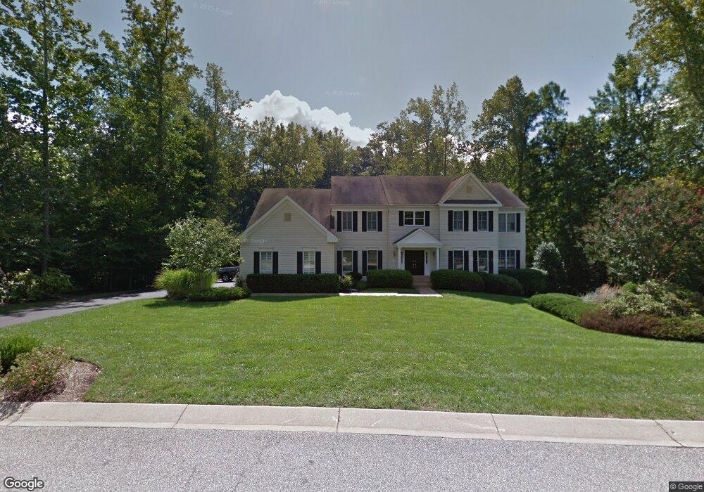
1509 Brewster Gate Rd Crownsville, MD 21032
Estimated Value: $1,141,817 - $1,339,000
--
Bed
4
Baths
4,383
Sq Ft
$286/Sq Ft
Est. Value
About This Home
This home is located at 1509 Brewster Gate Rd, Crownsville, MD 21032 and is currently estimated at $1,252,954, approximately $285 per square foot. 1509 Brewster Gate Rd is a home located in Anne Arundel County with nearby schools including Millersville Elementary School and Old Mill High School.
Ownership History
Date
Name
Owned For
Owner Type
Purchase Details
Closed on
Jun 28, 2019
Sold by
Bucht Erik S and Bucht Catherine A
Bought by
Bucht Catherine A
Current Estimated Value
Home Financials for this Owner
Home Financials are based on the most recent Mortgage that was taken out on this home.
Original Mortgage
$291,000
Interest Rate
3.82%
Mortgage Type
New Conventional
Purchase Details
Closed on
Jul 16, 2004
Sold by
Mcglynn Raymond J
Bought by
Bucht Erik S and Bucht Catherine A
Purchase Details
Closed on
Jun 29, 2004
Sold by
Mcglynn Raymond J
Bought by
Bucht Erik S and Bucht Catherine A
Purchase Details
Closed on
May 1, 1997
Sold by
The Preserve At Annap Ltd Ptnshp
Bought by
Mcglynn Raymond J and Mcglynn Susan M
Create a Home Valuation Report for This Property
The Home Valuation Report is an in-depth analysis detailing your home's value as well as a comparison with similar homes in the area
Home Values in the Area
Average Home Value in this Area
Purchase History
| Date | Buyer | Sale Price | Title Company |
|---|---|---|---|
| Bucht Catherine A | -- | Amrock Inc | |
| Bucht Erik S | $920,000 | -- | |
| Bucht Erik S | $920,000 | -- | |
| Mcglynn Raymond J | $397,766 | -- |
Source: Public Records
Mortgage History
| Date | Status | Borrower | Loan Amount |
|---|---|---|---|
| Previous Owner | Bucht Catherine A | $291,000 | |
| Closed | Bucht Erik S | -- |
Source: Public Records
Tax History Compared to Growth
Tax History
| Year | Tax Paid | Tax Assessment Tax Assessment Total Assessment is a certain percentage of the fair market value that is determined by local assessors to be the total taxable value of land and additions on the property. | Land | Improvement |
|---|---|---|---|---|
| 2025 | $8,693 | $863,467 | -- | -- |
| 2024 | $8,693 | $788,433 | $0 | $0 |
| 2023 | $7,790 | $713,400 | $159,200 | $554,200 |
| 2022 | $8,001 | $710,167 | $0 | $0 |
| 2021 | $15,934 | $706,933 | $0 | $0 |
| 2020 | $7,897 | $703,700 | $179,200 | $524,500 |
| 2019 | $7,904 | $703,700 | $179,200 | $524,500 |
| 2018 | $7,136 | $703,700 | $179,200 | $524,500 |
| 2017 | $8,410 | $778,900 | $0 | $0 |
| 2016 | -- | $767,500 | $0 | $0 |
| 2015 | -- | $756,100 | $0 | $0 |
| 2014 | -- | $744,700 | $0 | $0 |
Source: Public Records
Map
Nearby Homes
- 1500 Cheltenham Ct E
- 2545 Lavall Ct
- 1603 Huntcliff Way
- 2415 Pebblebrook Ct
- 1306 Lavall Dr
- 621 Wood Lot Trail Rd
- 2002 Huntwood Dr
- 934 Chesterfield Rd
- 2033 Huntwood Dr
- 2034 Huntwood Dr
- 2612 Quiet Water Cove Unit 24
- 1907 Mackiebeth Ct
- 932 Riversedge Cir
- 1007 Boom Ct
- 1909 Marconi Cir
- 2577 Rutland Rd
- 2828 Berth Ct
- 2057 Liza Way
- 1012 Mastline Dr
- 1909 Eleanor Ct
- 1507 Brewster Gate Rd
- 1510 Brewster Gate Rd
- 1512 Brewster Gate Rd
- 1508 Brewster Gate Rd
- 2047 Haverford Dr
- 1514 Brewster Gate Rd
- 1505 Brewster Gate Rd
- 2049 Haverford Dr
- 2051 Haverford Dr
- 1504 Brewster Gate Rd
- 1516 Brewster Gate Rd
- 1503 Habersham Place
- 1502 Brewster Gate Rd
- 2053 Haverford Dr
- 2041 Haverford Dr
- 1506 Brewster Gate Rd
- 1501 Habersham Place
- 1500 Brewster Gate Rd
- 1504 Cheltenham Ct E
- 2046 Haverford Dr