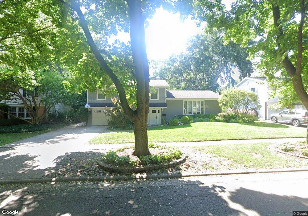
151 Blueberry Rd Libertyville, IL 60048
Estimated Value: $447,000 - $544,000
--
Bed
3
Baths
1,558
Sq Ft
$319/Sq Ft
Est. Value
About This Home
This home is located at 151 Blueberry Rd, Libertyville, IL 60048 and is currently estimated at $496,255, approximately $318 per square foot. 151 Blueberry Rd is a home located in Lake County with nearby schools including Butterfield School, Highland Middle School, and Libertyville High School.
Ownership History
Date
Name
Owned For
Owner Type
Purchase Details
Closed on
Oct 22, 1997
Sold by
Carlson Meredith A
Bought by
Carlson Meredith A and Meredith A Carlson Trust
Current Estimated Value
Purchase Details
Closed on
Nov 20, 1993
Sold by
Guarnery Joseph M and Thompson Jeanette L
Bought by
Carlson Meredith A
Home Financials for this Owner
Home Financials are based on the most recent Mortgage that was taken out on this home.
Original Mortgage
$100,000
Interest Rate
7.84%
Create a Home Valuation Report for This Property
The Home Valuation Report is an in-depth analysis detailing your home's value as well as a comparison with similar homes in the area
Home Values in the Area
Average Home Value in this Area
Purchase History
| Date | Buyer | Sale Price | Title Company |
|---|---|---|---|
| Carlson Meredith A | -- | -- | |
| Carlson Meredith A | $114,333 | -- |
Source: Public Records
Mortgage History
| Date | Status | Borrower | Loan Amount |
|---|---|---|---|
| Previous Owner | Carlson Meredith A | $100,000 |
Source: Public Records
Tax History Compared to Growth
Tax History
| Year | Tax Paid | Tax Assessment Tax Assessment Total Assessment is a certain percentage of the fair market value that is determined by local assessors to be the total taxable value of land and additions on the property. | Land | Improvement |
|---|---|---|---|---|
| 2024 | $10,776 | $153,740 | $69,809 | $83,931 |
| 2023 | $10,550 | $141,801 | $64,388 | $77,413 |
| 2022 | $10,550 | $137,913 | $61,888 | $76,025 |
| 2021 | $10,155 | $134,944 | $60,556 | $74,388 |
| 2020 | $9,772 | $132,675 | $59,538 | $73,137 |
| 2019 | $9,529 | $131,414 | $58,972 | $72,442 |
| 2018 | $9,343 | $133,206 | $53,203 | $80,003 |
| 2017 | $9,211 | $129,000 | $51,523 | $77,477 |
| 2016 | $8,901 | $122,310 | $48,851 | $73,459 |
| 2015 | $8,814 | $114,319 | $45,659 | $68,660 |
| 2014 | $8,251 | $110,573 | $44,163 | $66,410 |
| 2012 | $7,401 | $106,221 | $42,425 | $63,796 |
Source: Public Records
Map
Nearby Homes
- 223 Kenloch Ave
- 1137 Pine Tree Ln
- 1330 W Park Ave
- 20924 & 20902 W Park Ave
- 533 Drake St
- 551 W Park Ave Unit E
- 423 Ames St
- 0 Ames St
- 832 Interlaken Ln
- 420 W Cook Ave
- 505 Lange Ct
- 308 Mckinley Ave
- 212 Elm Ct
- 1754 Glenmore Rd
- 694 Parkside Ct
- 619 Parkside Ct
- 662 Parkside Ct
- 624 Parkside Ct
- 616 Parkside Ct
- 777 Garfield Ave Unit A
- 157 Blueberry Rd
- 145 Blueberry Rd
- 310 N Butterfield Rd
- 302 N Butterfield Rd
- 139 Blueberry Rd
- 163 Blueberry Rd
- 316 N Butterfield Rd
- 244 N Butterfield Rd
- 156 Blueberry Rd
- 150 Blueberry Rd
- 238 N Butterfield Rd
- 144 Blueberry Rd
- 324 N Butterfield Rd
- 169 Blueberry Rd
- 133 Blueberry Rd
- 168 Blueberry Rd
- 234 N Butterfield Rd
- 164 Acorn Ln
- 328 N Butterfield Rd
- 138 Blueberry Rd