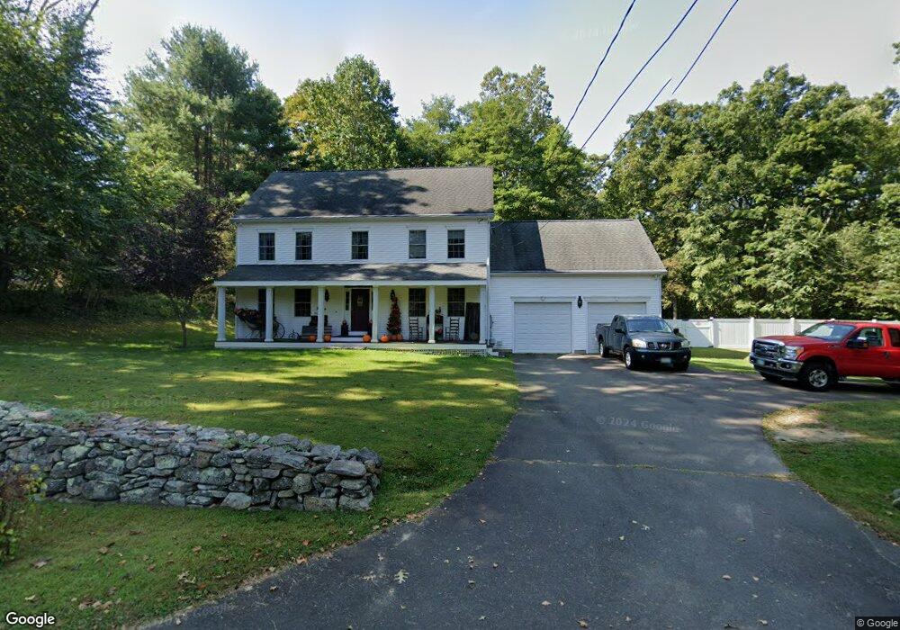
151 Cedar Swamp Rd Deep River, CT 06417
Estimated Value: $669,056 - $763,000
4
Beds
3
Baths
2,989
Sq Ft
$241/Sq Ft
Est. Value
About This Home
This home is located at 151 Cedar Swamp Rd, Deep River, CT 06417 and is currently estimated at $719,764, approximately $240 per square foot. 151 Cedar Swamp Rd is a home located in Middlesex County with nearby schools including Valley Regional High School.
Ownership History
Date
Name
Owned For
Owner Type
Purchase Details
Closed on
Apr 5, 2017
Sold by
Liscinsky Janice
Bought by
Dorso David and Liscinsky Janice
Current Estimated Value
Purchase Details
Closed on
Mar 3, 2003
Sold by
Cyr Michael
Bought by
Scott Karen and Andrews Shari
Home Financials for this Owner
Home Financials are based on the most recent Mortgage that was taken out on this home.
Original Mortgage
$275,000
Interest Rate
5.35%
Mortgage Type
Purchase Money Mortgage
Purchase Details
Closed on
Dec 28, 2001
Sold by
Sturges Michael D
Bought by
Cyr Michael
Purchase Details
Closed on
Jun 3, 1997
Sold by
Panico Edward J
Bought by
Sturges Michael D and Sturges Eoana A
Home Financials for this Owner
Home Financials are based on the most recent Mortgage that was taken out on this home.
Original Mortgage
$78,000
Interest Rate
5%
Mortgage Type
Purchase Money Mortgage
Create a Home Valuation Report for This Property
The Home Valuation Report is an in-depth analysis detailing your home's value as well as a comparison with similar homes in the area
Home Values in the Area
Average Home Value in this Area
Purchase History
| Date | Buyer | Sale Price | Title Company |
|---|---|---|---|
| Dorso David | -- | -- | |
| Scott Karen | $375,000 | -- | |
| Cyr Michael | $72,000 | -- | |
| Sturges Michael D | $80,000 | -- |
Source: Public Records
Mortgage History
| Date | Status | Borrower | Loan Amount |
|---|---|---|---|
| Previous Owner | Sturges Michael D | $100,000 | |
| Previous Owner | Sturges Michael D | $196,000 | |
| Previous Owner | Sturges Michael D | $275,000 | |
| Previous Owner | Sturges Michael D | $78,000 |
Source: Public Records
Tax History
| Year | Tax Paid | Tax Assessment Tax Assessment Total Assessment is a certain percentage of the fair market value that is determined by local assessors to be the total taxable value of land and additions on the property. | Land | Improvement |
|---|---|---|---|---|
| 2025 | $9,998 | $312,620 | $68,530 | $244,090 |
| 2024 | $9,810 | $312,620 | $68,530 | $244,090 |
| 2023 | $9,341 | $312,620 | $68,530 | $244,090 |
| 2022 | $9,060 | $312,620 | $68,530 | $244,090 |
| 2021 | $9,245 | $312,550 | $68,530 | $244,020 |
| 2020 | $8,502 | $283,500 | $56,910 | $226,590 |
| 2019 | $8,341 | $283,500 | $56,910 | $226,590 |
| 2018 | $8,341 | $283,500 | $56,910 | $226,590 |
| 2017 | $8,199 | $283,500 | $56,910 | $226,590 |
| 2016 | $7,805 | $283,500 | $56,910 | $226,590 |
Source: Public Records
Map
Nearby Homes
- 112 Cedar Swamp Rd
- 0 Glen Grove Rd
- 97 Bushy Hill Rd
- 151 Bushy Hill Rd
- 272 Westbrook Rd
- 120 Warsaw St
- 43 Bokum Rd
- 15 Hazen St
- 41 Bushy Hill Rd
- 46 Hemlock Dr
- 22 Ebony Ln
- 113 Winthrop Rd
- 23 Lynn Rd
- 29 Mitchel Terrace
- 25 Union St
- 7 Hickory Hill Dr
- 92 Main St Unit 101
- 209 Main St
- 87 Main St
- 11 Winter Ave
- 171 Cedar Swamp Rd
- 170 Cedar Swamp Rd
- 141 Cedar Swamp Rd
- 150 Cedar Swamp Rd
- 5 Hoopole Hill Rd
- 163 Cedar Swamp Rd
- 10 Hoopole Hill Rd
- 9 Hoopole Hill Rd
- 8 Hoopole Hill Rd
- 7 Hoopole Hill Rd
- 6 Hoopole Hill Rd
- 1 Hoopole Hill Rd
- 169 Cedar Swamp Rd
- 129 Cedar Swamp Rd
- 132 Cedar Swamp Rd
- 4 Hoopole Hill Rd
- 119 Cedar Swamp Rd
- 187 Cedar Swamp Rd
- 133 Cedar Swamp Rd
- 186 Cedar Swamp Rd
Your Personal Tour Guide
Ask me questions while you tour the home.