
Landlord's Agent in 2025
Samantha Muscato
Iconic Real Estate
(716) 603-8605
3 in this area
459 Total Sales

Estimated Value: $241,000 - $307,000
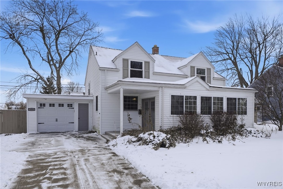
FOR RENT. 151 Conant is a 4 Bedroom Single Family Home. Attached Garage. Remodeled kitchen with stainless steel appliances. Separate laundry in the basement- washer/dryer included. Partially furnished with a living room set. Large living room and formal dining area. 2 Remodeled bathrooms. Central AC. Gas Oven/Range and Refrigerator, Microwave and Dishwasher also included. Close proximity and all the Tonawanda and Niagara Falls BLVD hotspots. Plenty of off street parking. Pets allowed, 1-2 dogs/cats. Application through Rentspree
Last Agent to Rent the Property
Listing by Iconic Real Estate License #40MU1035794 Listed on: 12/05/2025
Last Renter's Agent
Listing by Iconic Real Estate License #40MU1035794 Listed on: 12/05/2025
| Date | Buyer | Sale Price | Title Company |
|---|---|---|---|
| Mothena Casey | $210,000 | None Available | |
| Smyth Michael L | $65,000 | -- |
| Date | Status | Borrower | Loan Amount |
|---|---|---|---|
| Open | Mothena Casey | $168,000 |
| Date | Event | Price | List to Sale | Price per Sq Ft |
|---|---|---|---|---|
| 12/22/2025 12/22/25 | Rented | $2,495 | 0.0% | -- |
| 12/18/2025 12/18/25 | Under Contract | -- | -- | -- |
| 12/05/2025 12/05/25 | For Rent | $2,495 | -- | -- |
| Year | Tax Paid | Tax Assessment Tax Assessment Total Assessment is a certain percentage of the fair market value that is determined by local assessors to be the total taxable value of land and additions on the property. | Land | Improvement |
|---|---|---|---|---|
| 2025 | $6,878 | $54,600 | $10,100 | $44,500 |
| 2024 | $6,878 | $54,600 | $10,100 | $44,500 |
| 2023 | $6,717 | $54,600 | $10,100 | $44,500 |
| 2022 | $6,319 | $54,600 | $10,100 | $44,500 |
| 2021 | $6,297 | $54,600 | $10,100 | $44,500 |
| 2020 | $5,819 | $54,600 | $10,100 | $44,500 |
| 2019 | $5,505 | $54,600 | $10,100 | $44,500 |
| 2018 | $4,622 | $54,600 | $10,100 | $44,500 |
| 2017 | $2,897 | $54,600 | $10,100 | $44,500 |
| 2016 | $5,186 | $54,600 | $10,100 | $44,500 |
| 2015 | -- | $54,600 | $10,100 | $44,500 |
| 2014 | -- | $54,600 | $10,100 | $44,500 |
Landlord's Agent in 2025
Samantha Muscato
Iconic Real Estate
(716) 603-8605
3 in this area
459 Total Sales
Source: Western New York Real Estate Information Services (WNYREIS)
MLS Number: B1653010
APN: 146489-067-620-0005-028-000
Disclaimer: Certain information contained herein is derived from information provided by parties other than Homes.com. All information provided is deemed reliable, but is not guaranteed to be accurate and should be independently verified.
![]() The data relating to real estate on this web site comes in part from the Internet Data Exchange (IDX) Program of the CNYIS, UNYREIS and WNYREIS. Real estate listings held by firms other than Homes.com, LLC are marked with the IDX logo and include the Listing Broker’s Firm Name.
The data relating to real estate on this web site comes in part from the Internet Data Exchange (IDX) Program of the CNYIS, UNYREIS and WNYREIS. Real estate listings held by firms other than Homes.com, LLC are marked with the IDX logo and include the Listing Broker’s Firm Name.
Disclaimer: All information deemed reliable but not guaranteed and should be independently verified. All properties
are subject to prior sale, change or withdrawal. Neither the listing broker(s) nor Homes.com, LLC shall be responsible for any typographical errors, misinformation, misprints, and shall be held totally harmless.
© 2026 CNYIS, UNYREIS, WNYREIS. All rights reserved.
Ask me questions while you tour the home.