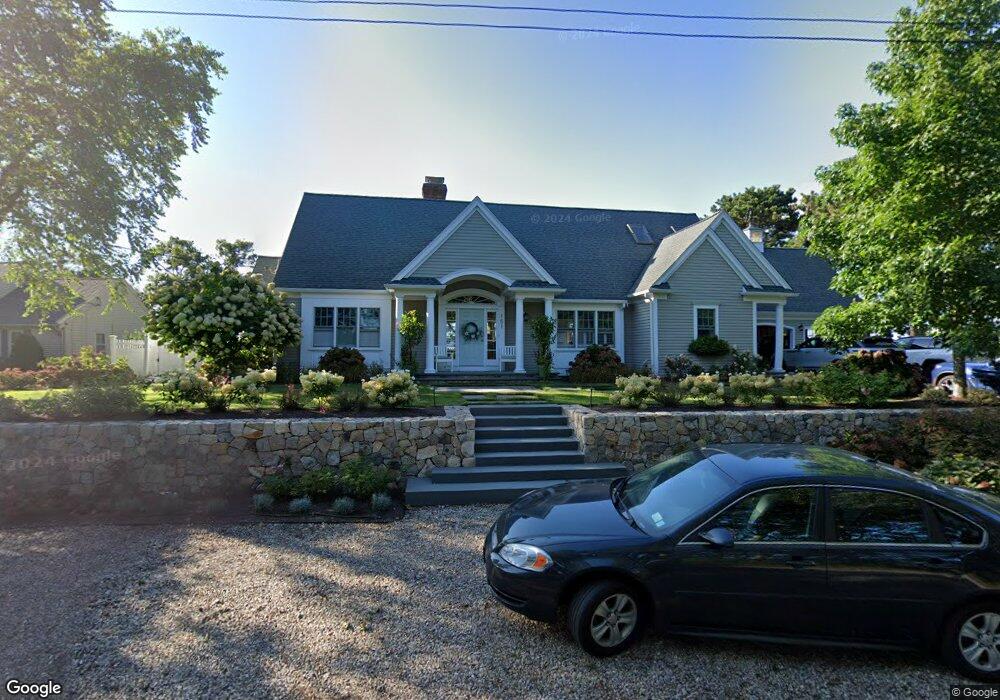
151 Cove Rd West Dennis, MA 02670
West Dennis NeighborhoodEstimated Value: $2,601,259 - $4,688,000
3
Beds
5
Baths
4,074
Sq Ft
$841/Sq Ft
Est. Value
About This Home
This home is located at 151 Cove Rd, West Dennis, MA 02670 and is currently estimated at $3,426,420, approximately $841 per square foot. 151 Cove Rd is a home located in Barnstable County with nearby schools including Dennis-Yarmouth Regional High School and St. Pius X. School.
Ownership History
Date
Name
Owned For
Owner Type
Purchase Details
Closed on
Apr 7, 2014
Sold by
Kizielewicz James J and Kizielewicz Carolyn P
Bought by
Carolyn P Kizielewic F P and Carolyn Kizielewicz
Current Estimated Value
Purchase Details
Closed on
Nov 6, 2008
Sold by
Soha Judith A and Soha Keneth J
Bought by
Kizielwicz Carolyn P and Kizielwicz James J
Home Financials for this Owner
Home Financials are based on the most recent Mortgage that was taken out on this home.
Original Mortgage
$600,000
Interest Rate
6.08%
Mortgage Type
Purchase Money Mortgage
Create a Home Valuation Report for This Property
The Home Valuation Report is an in-depth analysis detailing your home's value as well as a comparison with similar homes in the area
Home Values in the Area
Average Home Value in this Area
Purchase History
| Date | Buyer | Sale Price | Title Company |
|---|---|---|---|
| Carolyn P Kizielewic F P | -- | -- | |
| Carolyn P Kizielewic F | -- | -- | |
| Carolyn P Kizielewic F P | -- | -- | |
| Kizielwicz Carolyn P | $1,893,000 | -- | |
| Kizielwicz Carolyn P | $1,893,000 | -- |
Source: Public Records
Mortgage History
| Date | Status | Borrower | Loan Amount |
|---|---|---|---|
| Previous Owner | Kizielwicz Carolyn P | $322,500 | |
| Previous Owner | Kizielwicz Carolyn P | $600,000 |
Source: Public Records
Tax History Compared to Growth
Tax History
| Year | Tax Paid | Tax Assessment Tax Assessment Total Assessment is a certain percentage of the fair market value that is determined by local assessors to be the total taxable value of land and additions on the property. | Land | Improvement |
|---|---|---|---|---|
| 2025 | $10,137 | $2,341,200 | $794,400 | $1,546,800 |
| 2024 | $10,075 | $2,295,100 | $764,000 | $1,531,100 |
| 2023 | $9,807 | $2,100,100 | $702,700 | $1,397,400 |
| 2022 | $9,168 | $1,637,200 | $633,000 | $1,004,200 |
| 2021 | $8,821 | $1,462,900 | $649,400 | $813,500 |
| 2020 | $9,202 | $1,508,600 | $620,500 | $888,100 |
| 2019 | $8,694 | $1,409,000 | $608,400 | $800,600 |
| 2018 | $9,594 | $1,513,300 | $740,800 | $772,500 |
| 2017 | $9,307 | $1,513,300 | $740,800 | $772,500 |
| 2016 | $9,655 | $1,478,600 | $821,600 | $657,000 |
| 2015 | $9,463 | $1,478,600 | $821,600 | $657,000 |
| 2014 | $9,436 | $1,486,000 | $821,600 | $664,400 |
Source: Public Records
Map
Nearby Homes
- 428 Main St Unit 1-11
- 467 Main St
- 3 Pinefield Ln
- 401 Main St Unit 201
- 401 Main St Unit 101
- 295 Main St
- 23 Doric Ave
- 293 Main St
- 293 Main St
- 26 Center St
- 209 Main St Unit 3
- 209 Main St Unit 6
- 209 Main St Unit 1
- 209 Main St Unit 2
- 209 Main St Unit 4
- 209 Main St Unit 5
- 15 Woodside Park Rd
- 1 Country Club Dr
- 23 Fairwood Rd
- 21 Green Way