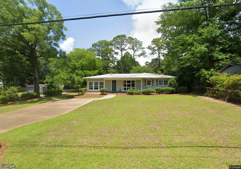
151 Fig Ave Fairhope, AL 36532
Estimated Value: $497,000 - $748,000
3
Beds
2
Baths
1,872
Sq Ft
$310/Sq Ft
Est. Value
About This Home
This home is located at 151 Fig Ave, Fairhope, AL 36532 and is currently estimated at $581,090, approximately $310 per square foot. 151 Fig Ave is a home located in Baldwin County with nearby schools including Fairhope West Elementary School, Fairhope Middle School, and Fairhope High School.
Ownership History
Date
Name
Owned For
Owner Type
Purchase Details
Closed on
Dec 22, 2006
Sold by
Eliason Mark and Patti Melissa
Bought by
Muller Dirk and Delmas Patricia L
Current Estimated Value
Home Financials for this Owner
Home Financials are based on the most recent Mortgage that was taken out on this home.
Original Mortgage
$230,000
Interest Rate
6.1%
Mortgage Type
Purchase Money Mortgage
Purchase Details
Closed on
Jun 1, 2005
Sold by
Loper Kirby Jean
Bought by
Eliason Mark and Patti Melissa
Create a Home Valuation Report for This Property
The Home Valuation Report is an in-depth analysis detailing your home's value as well as a comparison with similar homes in the area
Home Values in the Area
Average Home Value in this Area
Purchase History
| Date | Buyer | Sale Price | Title Company |
|---|---|---|---|
| Muller Dirk | -- | None Available | |
| Eliason Mark | -- | None Available |
Source: Public Records
Mortgage History
| Date | Status | Borrower | Loan Amount |
|---|---|---|---|
| Previous Owner | Muller Dirk | $230,000 |
Source: Public Records
Tax History Compared to Growth
Tax History
| Year | Tax Paid | Tax Assessment Tax Assessment Total Assessment is a certain percentage of the fair market value that is determined by local assessors to be the total taxable value of land and additions on the property. | Land | Improvement |
|---|---|---|---|---|
| 2024 | $5,232 | $113,740 | $85,940 | $27,800 |
| 2023 | $4,930 | $107,180 | $84,540 | $22,640 |
| 2022 | $4,421 | $96,100 | $0 | $0 |
| 2021 | $3,627 | $78,820 | $0 | $0 |
| 2020 | $0 | $74,920 | $0 | $0 |
| 2019 | $0 | $71,260 | $0 | $0 |
| 2018 | $2,780 | $64,640 | $0 | $0 |
| 2017 | $2,712 | $63,080 | $0 | $0 |
| 2016 | $3,060 | $70,760 | $0 | $0 |
| 2015 | -- | $52,480 | $0 | $0 |
| 2014 | -- | $50,900 | $0 | $0 |
| 2013 | -- | $48,700 | $0 | $0 |
Source: Public Records
Map
Nearby Homes
- 119 Orange Ave
- 152 Pinecrest Ln
- 462 Satsuma St
- 115 Pecan Ave
- 555 S Mobile St Unit 3
- 29 Paddock Dr
- 0 Fig Ave Unit 1/24 379134
- 156 Pier Ave
- 0 S Mobile St Unit 2 381294
- 119 Pier Ave
- 358 Kumquat St
- 403 S Mobile St
- 216 Fig Ave
- 358 Satsuma St
- 710 S Mobile St Unit 2
- 710 S Mobile St Unit 16
- 710 S Mobile St Unit 59
- 710 S Mobile St Unit 52
- 710 S Mobile St Unit 50
- 710 S Mobile St Unit 11