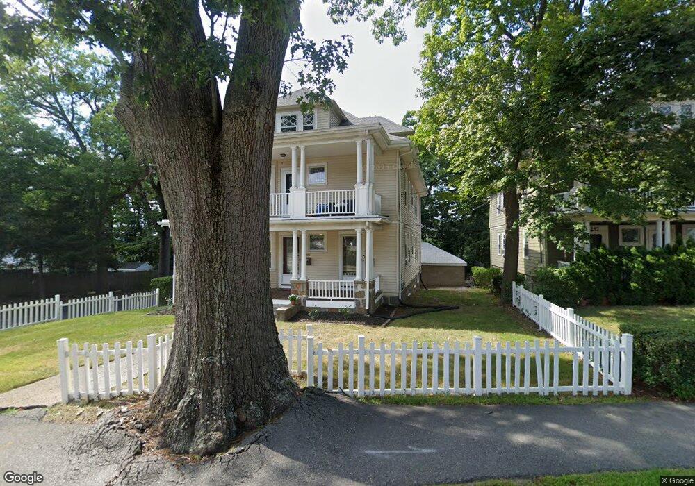
151 Kendrick Ave Quincy, MA 02169
South Quincy NeighborhoodEstimated Value: $927,000 - $1,165,000
6
Beds
2
Baths
3,234
Sq Ft
$330/Sq Ft
Est. Value
About This Home
This home is located at 151 Kendrick Ave, Quincy, MA 02169 and is currently estimated at $1,066,764, approximately $329 per square foot. 151 Kendrick Ave is a home located in Norfolk County with nearby schools including Lincoln-Hancock Community School, South West Middle School, and Quincy High School.
Ownership History
Date
Name
Owned For
Owner Type
Purchase Details
Closed on
Jun 4, 2008
Sold by
Calvi Grace M and Richardi Joanne M
Bought by
Quincy Joanne M Vitale and Vitale Joanne M
Current Estimated Value
Purchase Details
Closed on
Mar 15, 1989
Sold by
Salvaggio Robert
Bought by
Calvi Grace M
Home Financials for this Owner
Home Financials are based on the most recent Mortgage that was taken out on this home.
Original Mortgage
$160,000
Interest Rate
10.46%
Mortgage Type
Purchase Money Mortgage
Create a Home Valuation Report for This Property
The Home Valuation Report is an in-depth analysis detailing your home's value as well as a comparison with similar homes in the area
Home Values in the Area
Average Home Value in this Area
Purchase History
| Date | Buyer | Sale Price | Title Company |
|---|---|---|---|
| Quincy Joanne M Vitale | -- | -- | |
| Calvi Grace M | $230,000 | -- |
Source: Public Records
Mortgage History
| Date | Status | Borrower | Loan Amount |
|---|---|---|---|
| Previous Owner | Calvi Grace M | $157,000 | |
| Previous Owner | Calvi Grace M | $160,000 |
Source: Public Records
Tax History Compared to Growth
Tax History
| Year | Tax Paid | Tax Assessment Tax Assessment Total Assessment is a certain percentage of the fair market value that is determined by local assessors to be the total taxable value of land and additions on the property. | Land | Improvement |
|---|---|---|---|---|
| 2025 | $11,502 | $997,600 | $276,200 | $721,400 |
| 2024 | $10,849 | $962,600 | $263,000 | $699,600 |
| 2023 | $10,183 | $914,900 | $239,100 | $675,800 |
| 2022 | $10,235 | $854,300 | $199,300 | $655,000 |
| 2021 | $10,428 | $859,000 | $199,300 | $659,700 |
| 2020 | $10,137 | $815,500 | $199,300 | $616,200 |
| 2019 | $9,657 | $769,500 | $188,000 | $581,500 |
| 2018 | $8,972 | $672,600 | $174,100 | $498,500 |
| 2017 | $9,035 | $637,600 | $165,800 | $471,800 |
| 2016 | $7,780 | $541,800 | $144,100 | $397,700 |
| 2015 | $7,610 | $521,200 | $144,100 | $377,100 |
| 2014 | $6,537 | $439,900 | $144,100 | $295,800 |
Source: Public Records
Map
Nearby Homes
- 155 Kendrick Ave Unit T7
- 83 Madison Ave
- 166 Phipps St
- 72 Federal Ave
- 5 Pearl St
- 10 Hughes St
- 57 Summer St
- 8 Jackson St Unit B2
- 195 Independence Ave Unit 137
- 218 Independence Ave Unit B
- 102 Conrad St
- 106 Home Park Rd
- 94 Brook Rd Unit 3
- 9 Independence Ave Unit 212
- 25 John Paul Cir
- 33 Brook Rd
- 161 Cedar St
- 11 Rogers Cir
- 165 Granite St
- 18 Cliveden St Unit 406W
- 147 Kendrick Ave
- 157 Kendrick Ave
- 139 Kendrick Ave
- 141 Kendrick Ave Unit 1
- 141 Kendrick Ave Unit 141
- 161 Kendrick Ave
- 161 Kendrick Ave
- 161 Kendrick Ave
- 161 Kendrick Ave Unit 2
- 161 Kendrick Ave Unit 161
- 4 Alton Rd
- 163 Kendrick Ave
- 163 Kendrick Ave Unit 163
- 146 Kendrick Ave
- 133 Kendrick Ave
- 133 Kendrick Ave Unit 3
- 133 Kendrick Ave Unit 2
- 135 Kendrick Ave Unit 1
- 162 Kendrick Ave
- 167 Kendrick Ave