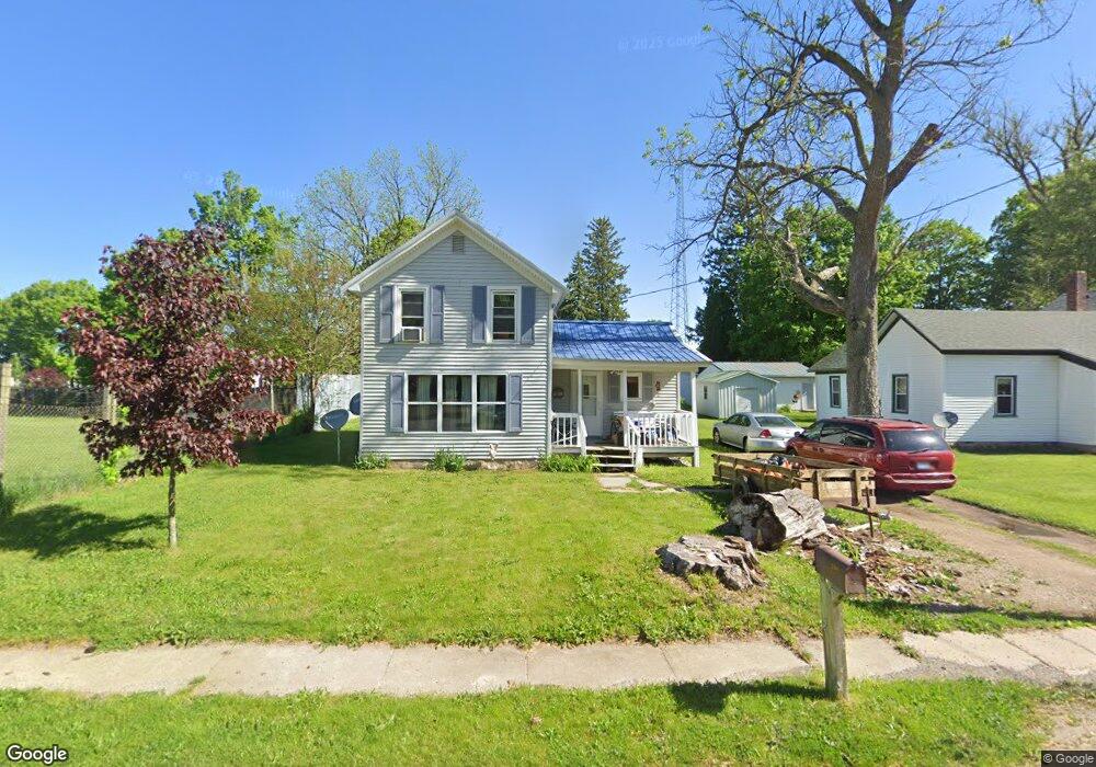
151 Maple St Delton, MI 49046
Estimated Value: $153,663 - $214,000
3
Beds
1
Bath
1,050
Sq Ft
$177/Sq Ft
Est. Value
About This Home
This home is located at 151 Maple St, Delton, MI 49046 and is currently estimated at $185,916, approximately $177 per square foot. 151 Maple St is a home located in Barry County with nearby schools including Delton Kellogg Elementary School, Delton-Kellogg Middle School, and Delton-Kellogg High School.
Ownership History
Date
Name
Owned For
Owner Type
Purchase Details
Closed on
Mar 3, 2023
Sold by
Wabeke Jared M
Bought by
Jared And Sarah Wabeke Trust
Current Estimated Value
Purchase Details
Closed on
Oct 8, 2010
Sold by
Deutsche Bank National Trust Company
Bought by
Eh Pooled 810 Lp
Purchase Details
Closed on
Sep 9, 2010
Sold by
Eh Pooled 810 Lp
Bought by
Wabeke Jay M and Wabeke Charlene J
Purchase Details
Closed on
Jul 9, 2009
Sold by
Thomas Jason M and Thomas Kelly R
Bought by
Deutsche Bank National Trust Company
Purchase Details
Closed on
Sep 6, 2005
Sold by
Thomas Jason and Thomas Kelli R
Bought by
Thomas Jason M and Thomas Kelli R
Home Financials for this Owner
Home Financials are based on the most recent Mortgage that was taken out on this home.
Original Mortgage
$89,495
Interest Rate
8.6%
Mortgage Type
New Conventional
Create a Home Valuation Report for This Property
The Home Valuation Report is an in-depth analysis detailing your home's value as well as a comparison with similar homes in the area
Purchase History
| Date | Buyer | Sale Price | Title Company |
|---|---|---|---|
| Jared And Sarah Wabeke Trust | -- | -- | |
| Wabeke Jared M | $25,000 | -- | |
| Eh Pooled 810 Lp | $12,451 | None Available | |
| Wabeke Jay M | $16,000 | None Available | |
| Wabeke Jay M | $16,000 | None Available | |
| Deutsche Bank National Trust Company | $50,700 | None Available | |
| Thomas Jason M | -- | Michigan Title |
Source: Public Records
Mortgage History
| Date | Status | Borrower | Loan Amount |
|---|---|---|---|
| Previous Owner | Thomas Jason M | $89,495 |
Source: Public Records
Tax History
| Year | Tax Paid | Tax Assessment Tax Assessment Total Assessment is a certain percentage of the fair market value that is determined by local assessors to be the total taxable value of land and additions on the property. | Land | Improvement |
|---|---|---|---|---|
| 2025 | $653 | $53,600 | $0 | $0 |
| 2024 | -- | $52,200 | $0 | $0 |
| 2023 | $653 | $36,200 | $0 | $0 |
| 2022 | $653 | $36,200 | $0 | $0 |
| 2021 | $653 | $34,600 | $0 | $0 |
| 2020 | $446 | $32,000 | $0 | $0 |
| 2019 | $446 | $30,600 | $0 | $0 |
| 2018 | $0 | $29,500 | $0 | $0 |
| 2017 | $0 | $28,900 | $0 | $0 |
| 2016 | -- | $24,600 | $0 | $0 |
| 2015 | -- | $23,300 | $0 | $0 |
| 2014 | -- | $23,300 | $0 | $0 |
Source: Public Records
Map
Nearby Homes
- 135 Mill St
- 736 S Grove St
- 10798 Pleasant Lake Rd
- 11070 E Shore Dr
- 11175 E Shore Dr
- 11178 E Shore Dr
- 11023 Pennock Ln
- 11575 Floria Rd
- 11366 E Shore Dr
- 9374 Michigan 43
- 11861 Floria Rd
- 6961 Shoreline Dr
- 00E N Bay Rd
- 000F N Bay Rd
- 5037 2nd St
- 9059 S M 43 Hwy
- 8572 Anchor Dr
- 8771 Chain O Lakes Dr
- 000B Kingsbury Rd
- 000A Kingsbury Rd
Your Personal Tour Guide
Ask me questions while you tour the home.