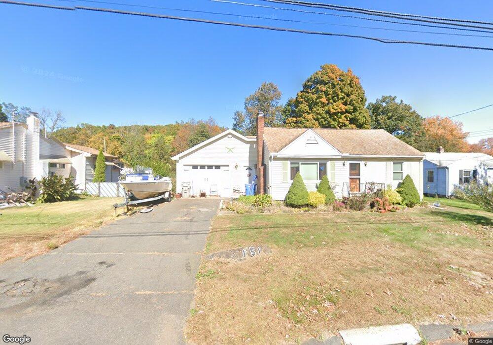
151 Mine Rd Bristol, CT 06010
North Bristol NeighborhoodEstimated Value: $293,000 - $344,000
2
Beds
1
Bath
832
Sq Ft
$376/Sq Ft
Est. Value
About This Home
This home is located at 151 Mine Rd, Bristol, CT 06010 and is currently estimated at $312,747, approximately $375 per square foot. 151 Mine Rd is a home located in Hartford County with nearby schools including Ivy Drive School, Northeast Middle School, and Bristol Eastern High School.
Ownership History
Date
Name
Owned For
Owner Type
Purchase Details
Closed on
Oct 18, 2023
Sold by
Pelletier Michelle L
Bought by
Pelletier Glenn S
Current Estimated Value
Home Financials for this Owner
Home Financials are based on the most recent Mortgage that was taken out on this home.
Original Mortgage
$200,000
Outstanding Balance
$194,514
Interest Rate
6.25%
Mortgage Type
Adjustable Rate Mortgage/ARM
Estimated Equity
$118,233
Purchase Details
Closed on
Sep 2, 2003
Sold by
Collins Allen B and Collins Nancy D
Bought by
Pelletier Glen S and Pelletier Michelle L
Purchase Details
Closed on
Sep 11, 1995
Sold by
Borkowski Ann
Bought by
Collins Allen B and Collins Nancy
Create a Home Valuation Report for This Property
The Home Valuation Report is an in-depth analysis detailing your home's value as well as a comparison with similar homes in the area
Home Values in the Area
Average Home Value in this Area
Purchase History
| Date | Buyer | Sale Price | Title Company |
|---|---|---|---|
| Pelletier Glenn S | -- | None Available | |
| Pelletier Glenn S | -- | None Available | |
| Pelletier Glen S | $164,000 | -- | |
| Collins Allen B | $84,000 | -- | |
| Pelletier Glen S | $164,000 | -- | |
| Collins Allen B | $84,000 | -- |
Source: Public Records
Mortgage History
| Date | Status | Borrower | Loan Amount |
|---|---|---|---|
| Open | Pelletier Glenn S | $200,000 | |
| Closed | Pelletier Glenn S | $200,000 | |
| Previous Owner | Collins Allen B | $133,798 | |
| Previous Owner | Collins Allen B | $10,000 |
Source: Public Records
Tax History
| Year | Tax Paid | Tax Assessment Tax Assessment Total Assessment is a certain percentage of the fair market value that is determined by local assessors to be the total taxable value of land and additions on the property. | Land | Improvement |
|---|---|---|---|---|
| 2025 | $5,138 | $152,250 | $50,610 | $101,640 |
| 2024 | $4,849 | $152,250 | $50,610 | $101,640 |
| 2023 | $4,549 | $149,870 | $50,610 | $99,260 |
| 2022 | $3,922 | $102,270 | $35,140 | $67,130 |
| 2021 | $3,922 | $102,270 | $35,140 | $67,130 |
| 2020 | $3,922 | $102,270 | $35,140 | $67,130 |
| 2019 | $3,891 | $102,270 | $35,140 | $67,130 |
| 2018 | $3,772 | $102,270 | $35,140 | $67,130 |
| 2017 | $4,078 | $113,190 | $50,190 | $63,000 |
| 2016 | $4,078 | $113,190 | $50,190 | $63,000 |
| 2015 | $3,918 | $113,190 | $50,190 | $63,000 |
| 2014 | $3,918 | $113,190 | $50,190 | $63,000 |
Source: Public Records
Map
Nearby Homes
- 84 Glen Eagle Dr
- 1004 Jerome Ave
- 25 Sheffield Ln
- 419 Jerome Ave
- 6 Pine Hill Rd
- 104 Driftwood Rd
- 1252 Burlington Ave
- 35 Jasmine St
- 354 Maple Ave
- 97 Jacqueline Dr
- 19 Woodside Way
- 3 Sandra St
- 60 Wildcat Rd
- 454 Maple Ave
- 209 Ashley Rd
- 50 Woodhaven Dr
- 15 Bittersweet Ln
- 12 Woodside St
- 24 Green Woods Ln
- 16 Strong St
Your Personal Tour Guide
Ask me questions while you tour the home.