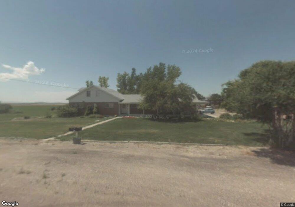
151 N 4600 W Fillmore, UT 84631
Estimated Value: $454,000 - $514,000
--
Bed
--
Bath
--
Sq Ft
1.47
Acres
About This Home
This home is located at 151 N 4600 W, Fillmore, UT 84631 and is currently estimated at $488,899. 151 N 4600 W is a home.
Ownership History
Date
Name
Owned For
Owner Type
Purchase Details
Closed on
Dec 7, 2023
Sold by
Fuller Matthew R and Fuller Jennifer Lynne
Bought by
Fuller Family Farms Llc
Current Estimated Value
Purchase Details
Closed on
Mar 12, 2021
Sold by
First Amercian Title Insurance Co
Bought by
Utah Community Cu
Purchase Details
Closed on
Oct 28, 2019
Sold by
Fuller Anthony P and Fuller Diana D
Bought by
Fuller Anthony and Fuller Diana D
Purchase Details
Closed on
May 29, 2009
Sold by
Fuller Anthony and Fuller Diana D
Bought by
Fuller Anthony P and Fuller Diana D
Home Financials for this Owner
Home Financials are based on the most recent Mortgage that was taken out on this home.
Original Mortgage
$140,000
Interest Rate
4.78%
Mortgage Type
New Conventional
Create a Home Valuation Report for This Property
The Home Valuation Report is an in-depth analysis detailing your home's value as well as a comparison with similar homes in the area
Home Values in the Area
Average Home Value in this Area
Purchase History
| Date | Buyer | Sale Price | Title Company |
|---|---|---|---|
| Fuller Family Farms Llc | -- | None Listed On Document | |
| Utah Community Cu | -- | None Available | |
| Fuller Anthony | -- | None Available | |
| Fuller Anthony P | -- | -- |
Source: Public Records
Mortgage History
| Date | Status | Borrower | Loan Amount |
|---|---|---|---|
| Previous Owner | Fuller Anthony P | $140,000 |
Source: Public Records
Tax History Compared to Growth
Tax History
| Year | Tax Paid | Tax Assessment Tax Assessment Total Assessment is a certain percentage of the fair market value that is determined by local assessors to be the total taxable value of land and additions on the property. | Land | Improvement |
|---|---|---|---|---|
| 2025 | $2,128 | $283,210 | $20,152 | $263,058 |
| 2024 | $2,128 | $296,843 | $14,561 | $282,282 |
| 2023 | $2,302 | $296,843 | $14,561 | $282,282 |
| 2022 | $1,753 | $167,865 | $14,250 | $153,615 |
| 2021 | $1,461 | $135,062 | $12,600 | $122,462 |
| 2020 | $1,401 | $131,240 | $12,600 | $118,640 |
| 2019 | $1,271 | $119,967 | $12,600 | $107,367 |
| 2018 | $1,239 | $119,967 | $12,600 | $107,367 |
| 2017 | $1,261 | $116,667 | $9,300 | $107,367 |
| 2016 | $1,203 | $116,667 | $9,300 | $107,367 |
| 2015 | $1,129 | $109,439 | $9,300 | $100,139 |
| 2014 | -- | $109,439 | $9,300 | $100,139 |
| 2013 | -- | $109,439 | $9,300 | $100,139 |
Source: Public Records
Map
Nearby Homes
- 7500 N 3900 Rd W
- 1360 N 3900 West Rd
- 2000 N West Frontage I-15
- 400 W 2600 North St
- 1565 W Sunflower Ln Unit 3
- 1615 W Sunflower Ln
- 1615 W Sunflower Ln Unit 4
- 1565 W Sunflower Ln
- 3700 W 5800 N
- 205 N 100 E
- 410 W 400 N
- 1100 S 725 Rd W
- 310 S 500 West Rd
- 335 W 400 North St
- 60 W Center St
- 50 N 100 Rd E
- 225 W 200 St N
- 380 N 200 St W
- 190 W 400 St S
- 75 N 100 West St