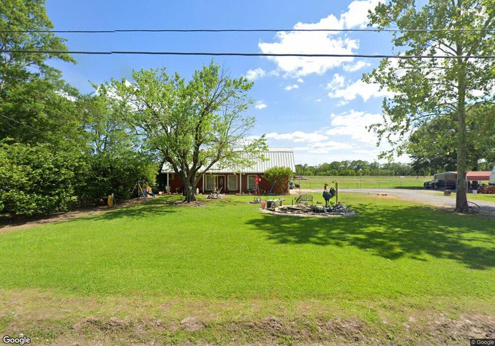
151 Ray Pardue Rd Duson, LA 70529
North Lafayette Parish NeighborhoodEstimated Value: $181,000 - $212,000
Studio
--
Bath
1,515
Sq Ft
$129/Sq Ft
Est. Value
About This Home
This home is located at 151 Ray Pardue Rd, Duson, LA 70529 and is currently estimated at $194,752, approximately $128 per square foot. 151 Ray Pardue Rd is a home located in Lafayette Parish with nearby schools including Charles M. Burke Elementary School, Judice Middle School, and Acadiana High School.
Ownership History
Date
Name
Owned For
Owner Type
Purchase Details
Closed on
Sep 13, 2019
Sold by
Guidry Melanie R
Bought by
Guidry Leger David Lee and Guidry Leger Janet
Current Estimated Value
Home Financials for this Owner
Home Financials are based on the most recent Mortgage that was taken out on this home.
Original Mortgage
$147,537
Outstanding Balance
$129,231
Interest Rate
3.6%
Mortgage Type
FHA
Estimated Equity
$65,521
Purchase Details
Closed on
Nov 10, 2006
Sold by
Lea Meredith M and Villarreal Xavier A
Bought by
Guidry Melanie R
Create a Home Valuation Report for This Property
The Home Valuation Report is an in-depth analysis detailing your home's value as well as a comparison with similar homes in the area
Home Values in the Area
Average Home Value in this Area
Purchase History
| Date | Buyer | Sale Price | Title Company |
|---|---|---|---|
| Guidry Leger David Lee | $155,000 | None Available | |
| Guidry Melanie R | -- | None Available |
Source: Public Records
Mortgage History
| Date | Status | Borrower | Loan Amount |
|---|---|---|---|
| Open | Guidry Leger David Lee | $147,537 |
Source: Public Records
Tax History
| Year | Tax Paid | Tax Assessment Tax Assessment Total Assessment is a certain percentage of the fair market value that is determined by local assessors to be the total taxable value of land and additions on the property. | Land | Improvement |
|---|---|---|---|---|
| 2024 | $647 | $14,826 | $2,100 | $12,726 |
| 2023 | $647 | $14,250 | $2,100 | $12,150 |
| 2022 | $1,255 | $14,250 | $2,100 | $12,150 |
| 2021 | $1,260 | $14,250 | $2,100 | $12,150 |
| 2020 | $1,259 | $14,250 | $2,100 | $12,150 |
| 2019 | $567 | $14,250 | $2,100 | $12,150 |
| 2018 | $579 | $14,250 | $2,100 | $12,150 |
| 2017 | $578 | $14,250 | $2,100 | $12,150 |
| 2015 | $256 | $10,500 | $1,500 | $9,000 |
| 2013 | -- | $10,500 | $1,500 | $9,000 |
Source: Public Records
Map
Nearby Homes
- 600 S Fieldspan Rd
- 202 Eagle Heights Dr
- 200 Eagle Heights Dr
- 100 Eagle Heights Dr
- 102 Eagle Heights Dr
- 104 Eagle Heights Dr
- 106 Eagle Heights Dr
- 1600 Blk S Fieldspan Rd
- 1100 S Fieldspan Rd Unit Lot B
- 1600-A Blk S Fieldspan Rd
- 1100 S Fieldspan Rd Unit Lot A
- 110 Eagle Heights Dr
- 112 Eagle Heights Dr
- 237 Oak Heights Dr
- 240 Oak Heights Dr
- 300 Oak Heights Dr
- 1700-A Blk S Fieldspan Rd
- Lot 2 W Congress St
- 1700-B Blk S Fieldspan Rd
- 1700-C Blk S Fieldspan Rd
- 140 Ray Pardue Rd
- 210 Ray Pardue Rd
- 150 Ray Pardue Rd
- 139 Ray Pardue Rd
- 2180 S Fieldspan Rd
- 120 Halpern Rd
- 2164 S Fieldspan Rd
- 137 Halpern Rd
- 103 Ray Pardue Rd
- 2174 S Fieldspan Rd
- 135 Halpern Rd
- 101 Ray Pardue Rd
- 106 Ray Pardue Rd
- 133 Halpern Rd
- 136 Halpern Rd
- 2186 S Fieldspan Rd
- 131 Halpern Rd
- 134 Halpern Rd
- 2140 S Fieldspan Rd
- 2400 S Fieldspan Rd
Your Personal Tour Guide
Ask me questions while you tour the home.