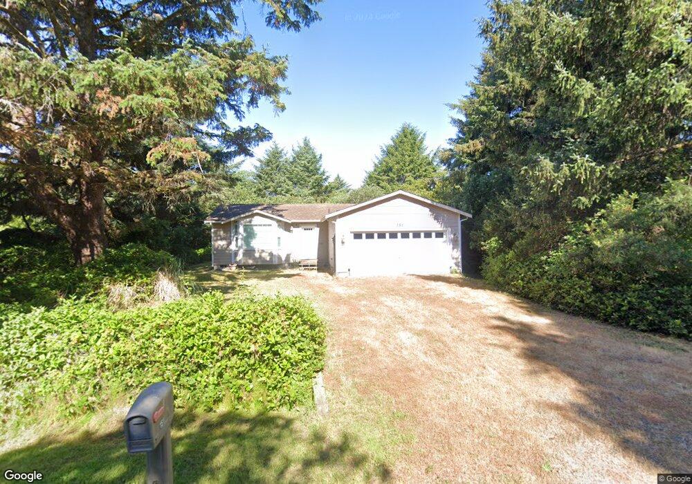
151 S Port Loop SW Ocean Shores, WA 98569
Estimated Value: $319,795 - $389,000
--
Bed
--
Bath
1,065
Sq Ft
$326/Sq Ft
Est. Value
About This Home
This home is located at 151 S Port Loop SW, Ocean Shores, WA 98569 and is currently estimated at $346,699, approximately $325 per square foot. 151 S Port Loop SW is a home located in Grays Harbor County with nearby schools including North Beach Junior/Senior High School.
Ownership History
Date
Name
Owned For
Owner Type
Purchase Details
Closed on
Dec 11, 2019
Sold by
Clark Geoffrey A and Estate Of William H Clark
Bought by
Clark Geoffrey A
Current Estimated Value
Purchase Details
Closed on
Oct 6, 2016
Sold by
Smith Joseph Fred
Bought by
Smith Kathleen Louise
Purchase Details
Closed on
Sep 10, 2010
Sold by
Winkler Frederick J and Winkler Marti L
Bought by
Clark William H and Clark Kathleen L
Purchase Details
Closed on
Oct 13, 2005
Sold by
Haskett Joseph and Haskett Malvina
Bought by
Winkler Frederick J and Winkler Marti L
Create a Home Valuation Report for This Property
The Home Valuation Report is an in-depth analysis detailing your home's value as well as a comparison with similar homes in the area
Home Values in the Area
Average Home Value in this Area
Purchase History
| Date | Buyer | Sale Price | Title Company |
|---|---|---|---|
| Clark Geoffrey A | -- | None Available | |
| Smith Kathleen Louise | -- | None Available | |
| Clark William H | $16,000 | Coast Title | |
| Winkler Frederick J | $34,000 | Coast Title |
Source: Public Records
Tax History Compared to Growth
Tax History
| Year | Tax Paid | Tax Assessment Tax Assessment Total Assessment is a certain percentage of the fair market value that is determined by local assessors to be the total taxable value of land and additions on the property. | Land | Improvement |
|---|---|---|---|---|
| 2025 | $1,855 | $292,876 | $45,000 | $247,876 |
| 2023 | $1,871 | $297,838 | $75,000 | $222,838 |
| 2022 | $1,880 | $222,372 | $54,200 | $168,172 |
| 2021 | $2,038 | $222,372 | $54,200 | $168,172 |
| 2020 | $1,909 | $197,371 | $37,375 | $159,996 |
| 2019 | $1,716 | $177,951 | $32,500 | $145,451 |
| 2018 | $1,813 | $155,814 | $25,000 | $130,814 |
| 2017 | $1,752 | $155,536 | $25,000 | $130,536 |
| 2016 | $1,717 | $147,070 | $22,000 | $125,070 |
| 2014 | -- | $129,645 | $12,000 | $117,645 |
| 2013 | -- | $143,390 | $15,000 | $128,390 |
Source: Public Records
Map
Nearby Homes
- 143 Aries Ct SW
- 209 S Oar Loop SW
- 199 S Narwhal Loop SW
- 219 S Oar Loop SW
- 195 Ocean Shores Blvd SW
- 122 Sand Dune Ave SW
- 241 Ocean Shores Blvd SW
- 189 Sand Dune Ave SW
- 146 Ocean Shores Blvd NW
- 167 Polaris Ave SW
- 105 Sand Dune Ave NW
- 102 N Oar Loop NW
- 209 Canal Dr SE
- 233 Canal Dr SE
- 317 Sand Dune Ave SW
- 148 N Narwhal Loop NW
- 165 N Narwhal Loop NW
- 371 Centaurus Ave SW
- 347 Sand Dune Ave SW
- 212 Point Brown Ave NE
- 151 S Port Loop SW
- 155 S Port Loop SW
- 166 Aurige Ave SW
- 160 Aurige Ave SW
- 159 S Port Loop SW
- 170 Aurige Ave SW
- 170 Auriga Ave SW
- 143 S Port Loop SW
- 156 Aurige Ave SW
- 176 Aurige Ave SW
- 176 Auriga Ave SW
- 148 S Port Loop SW
- 152 S Port Loop SW
- 163 S Port Loop SW
- 144 S Port Loop SW
- 150 Aurige Ave SW
- 142 S Port Loop SW
- 160 S Port Loop SW
- 180 Aurige Ave SW
- 139 S Port Loop SW