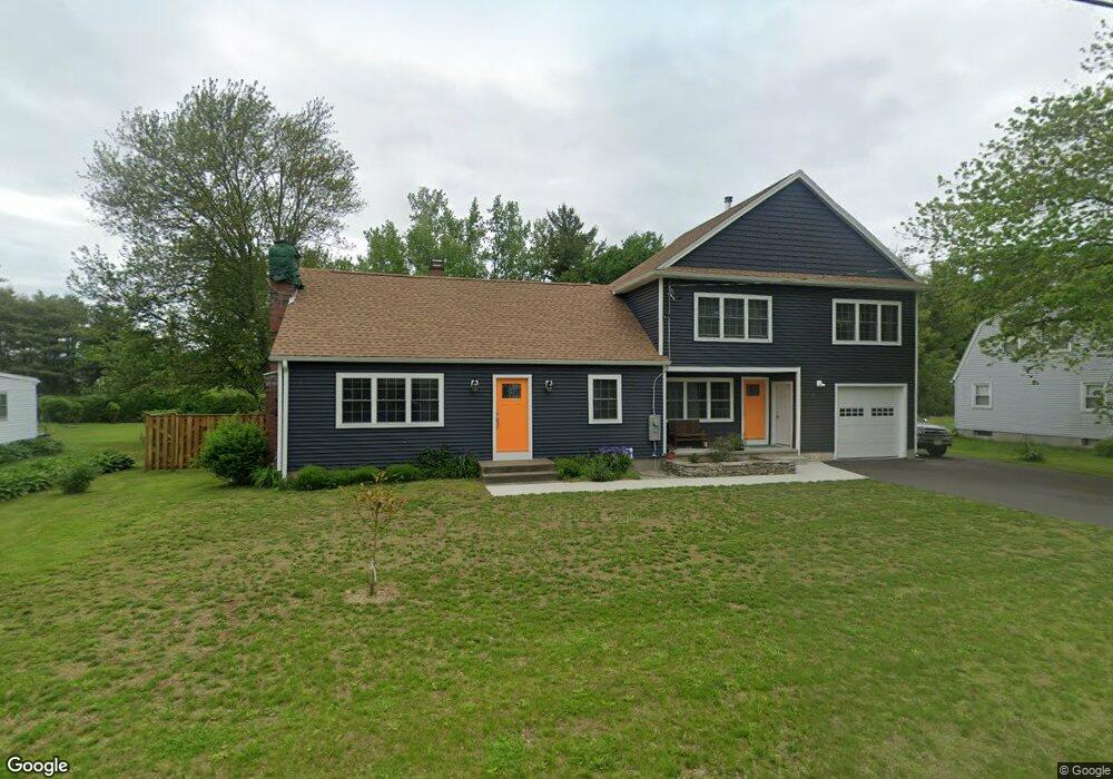
151 Sackett Rd Westfield, MA 01085
Estimated Value: $436,000 - $537,000
3
Beds
2
Baths
2,583
Sq Ft
$187/Sq Ft
Est. Value
About This Home
This home is located at 151 Sackett Rd, Westfield, MA 01085 and is currently estimated at $483,258, approximately $187 per square foot. 151 Sackett Rd is a home located in Hampden County with nearby schools including Westfield High School.
Ownership History
Date
Name
Owned For
Owner Type
Purchase Details
Closed on
Nov 5, 2015
Sold by
Sico Gary C and Sico Janine C
Bought by
Sico Chad E
Current Estimated Value
Home Financials for this Owner
Home Financials are based on the most recent Mortgage that was taken out on this home.
Original Mortgage
$158,000
Outstanding Balance
$124,653
Interest Rate
3.88%
Mortgage Type
New Conventional
Estimated Equity
$358,605
Create a Home Valuation Report for This Property
The Home Valuation Report is an in-depth analysis detailing your home's value as well as a comparison with similar homes in the area
Home Values in the Area
Average Home Value in this Area
Purchase History
| Date | Buyer | Sale Price | Title Company |
|---|---|---|---|
| Sico Chad E | $197,700 | -- |
Source: Public Records
Mortgage History
| Date | Status | Borrower | Loan Amount |
|---|---|---|---|
| Open | Sico Chad E | $158,000 |
Source: Public Records
Tax History Compared to Growth
Tax History
| Year | Tax Paid | Tax Assessment Tax Assessment Total Assessment is a certain percentage of the fair market value that is determined by local assessors to be the total taxable value of land and additions on the property. | Land | Improvement |
|---|---|---|---|---|
| 2025 | $5,940 | $391,300 | $118,500 | $272,800 |
| 2024 | $4,837 | $302,900 | $107,400 | $195,500 |
| 2023 | $4,293 | $262,500 | $102,300 | $160,200 |
| 2022 | $4,293 | $232,200 | $91,500 | $140,700 |
| 2021 | $4,159 | $220,300 | $86,400 | $133,900 |
| 2020 | $4,046 | $210,200 | $86,400 | $123,800 |
| 2019 | $3,952 | $200,900 | $82,100 | $118,800 |
| 2018 | $3,889 | $200,900 | $82,100 | $118,800 |
| 2017 | $3,830 | $197,200 | $83,500 | $113,700 |
| 2016 | $3,834 | $197,200 | $83,500 | $113,700 |
| 2015 | $3,686 | $198,800 | $83,500 | $115,300 |
| 2014 | $2,756 | $198,800 | $83,500 | $115,300 |
Source: Public Records
Map
Nearby Homes
- 444 Loomis St
- 197 Loomis Rg
- 53 Yankee Cir
- 0 Fox Hill Dr
- 508 Granville Rd
- 156 Honey Pot Rd
- 386 Hillside Rd
- 162 Honey Pot Rd
- 110 Kensington Ave
- 126 Western Cir
- 40 Heritage Ln
- 240 Hillside Rd
- 57 Jessie Ln
- 150 Hillside Rd Unit 11
- 128 Crane Ave
- 78 Granville Rd Unit 11
- 69 Beveridge Blvd
- 16 Spruce St
- 11 Highland Cir
- 44 Governor Dr
- 155 Sackett Rd
- 147 Sackett Rd
- 143 Sackett Rd
- 150 Sackett Rd
- 159 Sackett Rd
- 156 Sackett Rd
- 146 Sackett Rd
- 161 Sackett Rd
- 139 Sackett Rd
- 160 Sackett Rd
- 142 Sackett Rd
- 70 Janis Rd
- 133 Sackett Rd
- 166 Sackett Rd
- 11 Crescent Ridge Rd
- 19 Crescent Ridge Rd
- Lot 2 Sackett Rd
- Parcel A Sackett Rd
- 66 Janis Rd
- 127 Sackett Rd