Estimated Value: $383,648 - $436,000
Studio
2
Baths
1,688
Sq Ft
$242/Sq Ft
Est. Value
About This Home
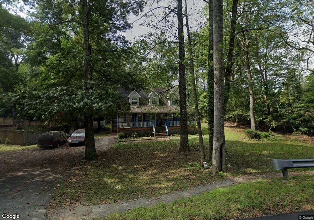
This home is located at 151 Thunderbird Dr, Lusby, MD 20657 and is currently estimated at $408,912, approximately $242 per square foot. 151 Thunderbird Dr is a home located in Calvert County with nearby schools including Patuxent Appeal Elementary Campus, Mill Creek Middle School, and Patuxent High School.
Ownership History
Date
Name
Owned For
Owner Type
Purchase Details
Closed on
Aug 26, 2002
Sold by
Norrell Michael S and Norrell Jennie
Bought by
Sollers Tyrone N and Sollers Carlene D
Current Estimated Value
Purchase Details
Closed on
Oct 22, 1993
Sold by
Chaney G F
Bought by
Norrell Michael S
Home Financials for this Owner
Home Financials are based on the most recent Mortgage that was taken out on this home.
Original Mortgage
$117,900
Interest Rate
6.73%
Purchase Details
Closed on
Jun 21, 1993
Sold by
Irwin Diane M
Bought by
Chaney George F
Create a Home Valuation Report for This Property
The Home Valuation Report is an in-depth analysis detailing your home's value as well as a comparison with similar homes in the area
Home Values in the Area
Average Home Value in this Area
Purchase History
| Date | Buyer | Sale Price | Title Company |
|---|---|---|---|
| Sollers Tyrone N | $172,400 | -- | |
| Norrell Michael S | $117,900 | -- | |
| Chaney George F | $11,500 | -- |
Source: Public Records
Mortgage History
| Date | Status | Borrower | Loan Amount |
|---|---|---|---|
| Previous Owner | Norrell Michael S | $117,900 | |
| Closed | Sollers Tyrone N | -- |
Source: Public Records
Tax History
| Year | Tax Paid | Tax Assessment Tax Assessment Total Assessment is a certain percentage of the fair market value that is determined by local assessors to be the total taxable value of land and additions on the property. | Land | Improvement |
|---|---|---|---|---|
| 2025 | $4,289 | $356,967 | $0 | $0 |
| 2024 | $3,989 | $329,633 | $0 | $0 |
| 2023 | $3,295 | $302,300 | $55,200 | $247,100 |
| 2022 | $3,089 | $297,267 | $0 | $0 |
| 2021 | $7,029 | $292,233 | $0 | $0 |
| 2020 | $6,503 | $287,200 | $55,200 | $232,000 |
| 2019 | $2,831 | $269,867 | $0 | $0 |
| 2018 | $2,649 | $252,533 | $0 | $0 |
| 2017 | $2,876 | $235,200 | $0 | $0 |
| 2016 | -- | $235,200 | $0 | $0 |
| 2015 | $3,182 | $235,200 | $0 | $0 |
| 2014 | $3,182 | $238,400 | $0 | $0 |
Source: Public Records
Map
Nearby Homes
- 221 Pawnee Ln
- 178 Thunderbird Dr
- 316 Geronimo Rd
- 11504 Lariat Ln
- 11546 Buckskin Ct
- 11850 Hg Trueman Rd
- 11457 Stirrup Ln
- 291 Red Cloud Rd
- 11436 Stirrup Ln
- 285 Red Cloud Rd
- 532 Shortbow Trail
- 12156 Rousby Hall Rd
- 11223 Rawhide Rd
- 11504 Durango Dr
- 11566 Durango Ct
- 10015 H G Trueman Rd
- 348 Red Cloud Rd
- 30 American Ln
- 11705 Big Bear Ln
- 11469 Chaves Ln
- 155 Thunderbird Dr
- 159 Thunderbird Dr
- 150 Thunderbird Dr
- 163 Thunderbird Dr
- 201 Pawnee Ln
- 162 Thunderbird Dr
- 205 Pawnee Ln
- 167 Thunderbird Dr
- 213 Pawnee Ln
- 235 Town Square Dr
- 166 Thunderbird Dr
- 215 Pawnee Ln
- 171 Thunderbird Dr
- 204 Pawnee Ln
- 210 Village Center Dr
- 217 Pawnee Ln
- 170 Thunderbird Dr
- 210 Pawnee Ln
- 175 Thunderbird Dr
- 301 Geronimo Rd
Your Personal Tour Guide
Ask me questions while you tour the home.