
Seller's Agent in 2025
Donald Fitzgerald, Jr.
Showcase Realty, Inc.
(203) 910-4260
51 in this area
91 Total Sales
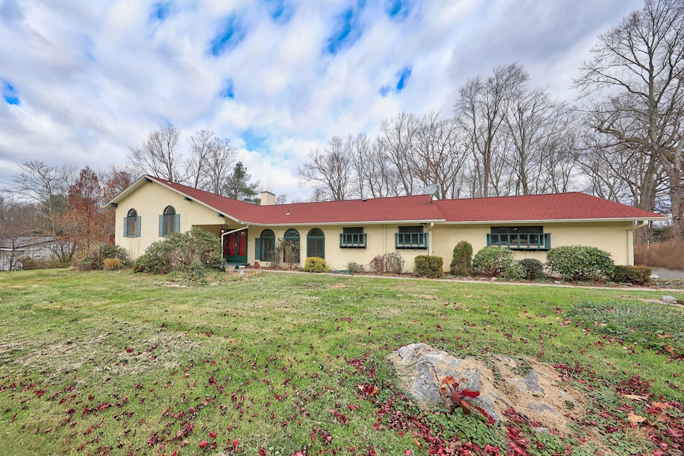
Welcome to 151 Timothy Rd located in the very desirable West side of Naugatuck, CT, a spacious and inviting 4 bedroom, 3.5 bath, oversize split level with potential for in-law set-up in the over 1,000 square foot lower level, which has its own fireplace, currently has a wet bar and walk out to a cement patio overlooking an inground pool situated on a generous almost 3/4 acre serene lot surrounded by mature trees, this spacious yard offers endless potential for outdoor enjoyment, gardening, and gatherings, the main level of this home features a bright and open main living area with large windows, a cozy living room with an additional fireplace and massive dining room for your formal gatherings, a newer functional kitchen has plenty of cabinets with granite counter tops and stainless steel appliances, the half bath and laundry room is on this main level as well, the double sided stair case leads to two well sized bedrooms and a hallway full bathroom, primary bedroom with its own full bathroom completes this level, all this providing a convenient and comfortable layout with many options for home office, gym, or playroom, endless possibilities within this almost 3,200 square foot solid built home that is in need of your personal TLC offered at an amazing price point, a peaceful setting without sacrificing convenience, just minutes from schools, parks, shopping, and major highways, this is a wonderful opportunity which you don't want to miss out on, call for your private showing
Last Agent to Sell the Property
Showcase Realty, Inc. Brokerage Phone: (203) 910-4260 License #RES.0769787 Listed on: 11/11/2025
| Date | Type | Sale Price | Title Company |
|---|---|---|---|
| Executors Deed | $430,000 | -- | |
| Quit Claim Deed | -- | None Available | |
| Warranty Deed | $242,000 | -- |
| Date | Status | Loan Amount | Loan Type |
|---|---|---|---|
| Previous Owner | $115,000 | No Value Available | |
| Previous Owner | $110,000 | Purchase Money Mortgage |
| Date | Event | Price | List to Sale | Price per Sq Ft |
|---|---|---|---|---|
| 12/30/2025 12/30/25 | Sold | $435,000 | +16.0% | $136 / Sq Ft |
| 11/28/2025 11/28/25 | Pending | -- | -- | -- |
| 11/20/2025 11/20/25 | For Sale | $374,900 | -- | $117 / Sq Ft |
| Year | Tax Paid | Tax Assessment Tax Assessment Total Assessment is a certain percentage of the fair market value that is determined by local assessors to be the total taxable value of land and additions on the property. | Land | Improvement |
|---|---|---|---|---|
| 2025 | $9,679 | $243,250 | $39,690 | $203,560 |
| 2024 | $10,165 | $243,250 | $39,690 | $203,560 |
| 2023 | $10,885 | $243,250 | $39,690 | $203,560 |
| 2022 | $10,026 | $209,970 | $41,830 | $168,140 |
| 2021 | $10,026 | $209,970 | $41,830 | $168,140 |
| 2020 | $10,026 | $209,970 | $41,830 | $168,140 |
| 2019 | $9,921 | $209,970 | $41,830 | $168,140 |
| 2018 | $9,810 | $202,900 | $58,950 | $143,950 |
| 2017 | $9,851 | $202,900 | $58,950 | $143,950 |
| 2016 | $9,672 | $202,900 | $58,950 | $143,950 |
| 2015 | $9,246 | $202,900 | $58,950 | $143,950 |
| 2014 | $9,143 | $202,900 | $58,950 | $143,950 |
| 2012 | $8,402 | $250,430 | $64,080 | $186,350 |
Seller's Agent in 2025
Donald Fitzgerald, Jr.
Showcase Realty, Inc.
(203) 910-4260
51 in this area
91 Total Sales
Buyer's Agent in 2025
Nick Prevost
William Raveis Real Estate
(860) 333-6330
1 in this area
43 Total Sales
Source: SmartMLS
MLS Number: 24139739
APN: NAUG-000085-W013186-B000088
Disclaimer: Certain information contained herein is derived from information provided by parties other than Homes.com. All information provided is deemed reliable, but is not guaranteed to be accurate and should be independently verified.
![]() IDX information is provided exclusively for personal, non-commercial use, and may not be used for any purpose other than to identify prospective properties consumers may be interested in purchasing. Information is deemed reliable but not guaranteed.
IDX information is provided exclusively for personal, non-commercial use, and may not be used for any purpose other than to identify prospective properties consumers may be interested in purchasing. Information is deemed reliable but not guaranteed.
Ask me questions while you tour the home.