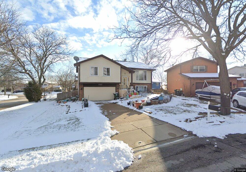
1510 Brookside Dr Hoffman Estates, IL 60169
South Hoffman Estates NeighborhoodEstimated Value: $342,000 - $420,000
3
Beds
2
Baths
1,025
Sq Ft
$371/Sq Ft
Est. Value
About This Home
This home is located at 1510 Brookside Dr, Hoffman Estates, IL 60169 and is currently estimated at $380,548, approximately $371 per square foot. 1510 Brookside Dr is a home located in Cook County with nearby schools including Neil Armstrong Elementary School, Dwight D Eisenhower Junior High School, and Hoffman Estates High School.
Ownership History
Date
Name
Owned For
Owner Type
Purchase Details
Closed on
Apr 26, 1994
Sold by
Lee Anthony G and Lee Mary A
Bought by
Patel Pankaj
Current Estimated Value
Home Financials for this Owner
Home Financials are based on the most recent Mortgage that was taken out on this home.
Original Mortgage
$110,000
Interest Rate
7.88%
Create a Home Valuation Report for This Property
The Home Valuation Report is an in-depth analysis detailing your home's value as well as a comparison with similar homes in the area
Home Values in the Area
Average Home Value in this Area
Purchase History
| Date | Buyer | Sale Price | Title Company |
|---|---|---|---|
| Patel Pankaj | $137,500 | -- |
Source: Public Records
Mortgage History
| Date | Status | Borrower | Loan Amount |
|---|---|---|---|
| Closed | Patel Pankaj | $110,000 |
Source: Public Records
Tax History
| Year | Tax Paid | Tax Assessment Tax Assessment Total Assessment is a certain percentage of the fair market value that is determined by local assessors to be the total taxable value of land and additions on the property. | Land | Improvement |
|---|---|---|---|---|
| 2025 | $3,283 | $30,000 | $6,244 | $23,756 |
| 2024 | $3,283 | $26,000 | $5,676 | $20,324 |
| 2023 | $3,278 | $26,000 | $5,676 | $20,324 |
| 2022 | $3,278 | $26,000 | $5,676 | $20,324 |
| 2021 | $3,600 | $20,916 | $8,939 | $11,977 |
| 2020 | $3,275 | $20,916 | $8,939 | $11,977 |
| 2019 | $3,240 | $23,240 | $8,939 | $14,301 |
| 2018 | $3,615 | $22,079 | $7,804 | $14,275 |
| 2017 | $3,488 | $22,079 | $7,804 | $14,275 |
| 2016 | $4,067 | $22,079 | $7,804 | $14,275 |
| 2015 | $4,606 | $18,837 | $6,811 | $12,026 |
| 2014 | $4,827 | $20,171 | $6,811 | $13,360 |
| 2013 | $4,238 | $20,171 | $6,811 | $13,360 |
Source: Public Records
Map
Nearby Homes
- 1587 Brookside Dr
- 1612 Islandview Ct
- 1659 Islandview Ct
- 1880 Bonnie Ln Unit 416
- 1880 Bonnie Ln Unit 112
- 1724 Fayette Walk Unit J
- 1769 Sessions Walk Unit C
- 1933 Williamsburg Dr Unit 1
- 1975 Windsong Dr Unit 333E1
- 1712 Fayette Walk Unit D
- 2051 Kettering Rd Unit 2
- 2021 Kensington Ln Unit 3004
- 2027 Kensington Ln Unit 3001
- 2025 Kensington Ln Unit 3002
- 2023 Kensington Ln Unit 3003
- 1026 Denham Place Unit 1
- 1986 Brighton Ln Unit 2
- 2267 Briar Ct Unit 65
- 1708 Southbridge Ct
- 1938 Huntington Blvd
- 1514 Brookside Dr
- 1500 Brookside Dr
- 1490 Brookside Dr
- 1518 Brookside Dr
- 2000 Brookside Ln
- 1475 Brookside Dr
- 1522 Brookside Dr
- 1573 Cornell Place Unit 13D
- 1573 Cornell Place Unit 1573
- 1486 Brookside Dr Unit 2
- 1575 Cornell Place Unit 13A
- 1525 Brookside Dr
- 1530 Brookside Dr
- 1583 Cornell Place Unit 14B
- 1577 Cornell Place Unit 13B
- 1571 Cornell Place Unit 13C
- 1571 Cornell Place Unit 1571
- 1526 Brookside Dr
- 1990 Brookside Ln Unit 4
- 1585 Cornell Place Unit 14C
Your Personal Tour Guide
Ask me questions while you tour the home.