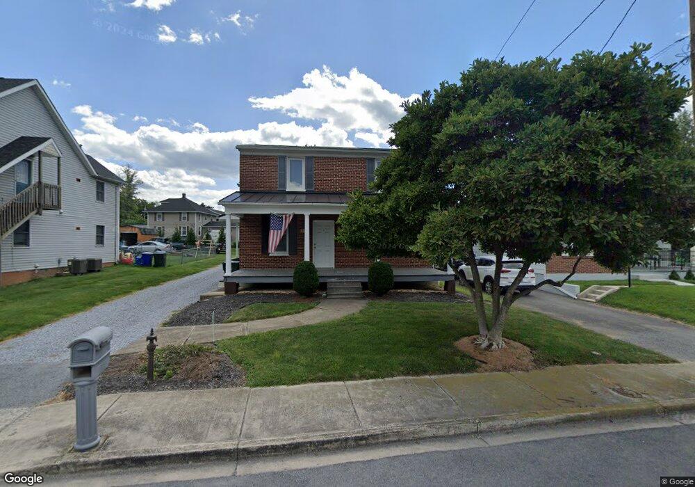
1511 Broadfording Rd Hagerstown, MD 21740
West End NeighborhoodEstimated Value: $244,594 - $295,000
3
Beds
2
Baths
1,680
Sq Ft
$164/Sq Ft
Est. Value
About This Home
This home is located at 1511 Broadfording Rd, Hagerstown, MD 21740 and is currently estimated at $274,899, approximately $163 per square foot. 1511 Broadfording Rd is a home located in Washington County with nearby schools including Salem Avenue Elementary School, Owendale-Gagetown Junior/Senior High School, and Western Heights Middle School.
Ownership History
Date
Name
Owned For
Owner Type
Purchase Details
Closed on
Jun 29, 1993
Sold by
Stottlemyer Elvin N and Stottlemyer Beverly K
Bought by
Glaze David Edward and Glaze Dianne M
Current Estimated Value
Home Financials for this Owner
Home Financials are based on the most recent Mortgage that was taken out on this home.
Original Mortgage
$83,640
Interest Rate
7.34%
Purchase Details
Closed on
Aug 27, 1987
Sold by
Foltz Ralph N
Bought by
Stottlemyer Elvin N and Stottlemyer Beverly K
Home Financials for this Owner
Home Financials are based on the most recent Mortgage that was taken out on this home.
Original Mortgage
$49,000
Interest Rate
10.3%
Create a Home Valuation Report for This Property
The Home Valuation Report is an in-depth analysis detailing your home's value as well as a comparison with similar homes in the area
Home Values in the Area
Average Home Value in this Area
Purchase History
| Date | Buyer | Sale Price | Title Company |
|---|---|---|---|
| Glaze David Edward | $82,000 | -- | |
| Stottlemyer Elvin N | $42,000 | -- |
Source: Public Records
Mortgage History
| Date | Status | Borrower | Loan Amount |
|---|---|---|---|
| Closed | Glaze David Edward | $83,640 | |
| Previous Owner | Stottlemyer Elvin N | $49,000 |
Source: Public Records
Tax History Compared to Growth
Tax History
| Year | Tax Paid | Tax Assessment Tax Assessment Total Assessment is a certain percentage of the fair market value that is determined by local assessors to be the total taxable value of land and additions on the property. | Land | Improvement |
|---|---|---|---|---|
| 2025 | $1,208 | $142,900 | $43,500 | $99,400 |
| 2024 | $1,208 | $132,567 | $0 | $0 |
| 2023 | $1,114 | $122,233 | $0 | $0 |
| 2022 | $1,019 | $111,900 | $43,500 | $68,400 |
| 2021 | $1,001 | $109,733 | $0 | $0 |
| 2020 | $1,001 | $107,567 | $0 | $0 |
| 2019 | $985 | $105,400 | $43,500 | $61,900 |
| 2018 | $985 | $105,400 | $43,500 | $61,900 |
| 2017 | $985 | $105,400 | $0 | $0 |
| 2016 | -- | $110,800 | $0 | $0 |
| 2015 | -- | $110,800 | $0 | $0 |
| 2014 | $2,249 | $110,800 | $0 | $0 |
Source: Public Records
Map
Nearby Homes
- 370 Daycotah Ave
- 1361 Connecticut Ave
- 1355 Connecticut Ave
- 1362 Connecticut Ave
- 511 Rhode Island Ave
- 259 Daycotah Ave
- 1321 Marshall St
- 367 Devonshire Rd
- 325 Devonshire Rd
- 12922 Salem Ave
- 212 Daycotah Ave
- 1059 Georgia Ave
- 239 Devonshire Rd
- 221 Devonshire Rd
- 1328 Outer Dr
- 1027 Florida Ave
- 1229 Wayne Ave
- 1181 Wayne Ave
- 12922 Nittany Lion Cir
- 1007 Florida Ave
- 1505 Broadfording Rd Unit 1507
- 1515 Broadfording Rd
- 1505 Broadfording 1507 Rd
- 1521 Broadfording Rd
- 1501 Broadfording Rd Unit 1503
- 1501 Broadfording 1503 Rd
- 373 Woodpoint Ave
- 392 Yorkshire Dr
- 394 Yorkshire Dr
- 390 Yorkshire Dr
- 371A Woodpoint Ave
- 371 AB Woodpoint Ave
- 388 Yorkshire Dr
- 1481 Salem Ave
- 369 Woodpoint Ave
- 386 Yorkshire Dr
- 1437 Salem Ave
- 367 A Woodpoint B Ave
- 384 Yorkshire Dr
- 1530 Broadfording Rd