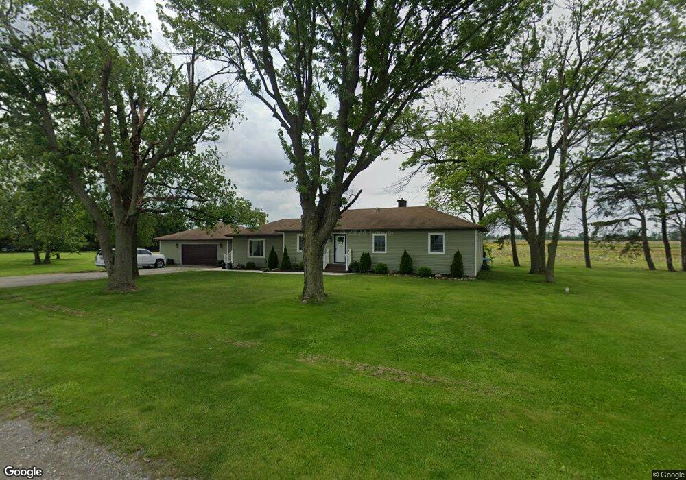
1511 E 121st Ave Crown Point, IN 46307
Estimated Value: $270,000 - $416,000
3
Beds
2
Baths
1,456
Sq Ft
$241/Sq Ft
Est. Value
About This Home
This home is located at 1511 E 121st Ave, Crown Point, IN 46307 and is currently estimated at $350,229, approximately $240 per square foot. 1511 E 121st Ave is a home located in Lake County with nearby schools including Winfield Elementary School, Colonel John Wheeler Middle School, and Crown Point High School.
Ownership History
Date
Name
Owned For
Owner Type
Purchase Details
Closed on
Dec 17, 2004
Sold by
Segert Ronald E and Segert Shirley S
Bought by
Hein Edward J
Current Estimated Value
Home Financials for this Owner
Home Financials are based on the most recent Mortgage that was taken out on this home.
Original Mortgage
$98,500
Interest Rate
5.77%
Mortgage Type
Fannie Mae Freddie Mac
Create a Home Valuation Report for This Property
The Home Valuation Report is an in-depth analysis detailing your home's value as well as a comparison with similar homes in the area
Home Values in the Area
Average Home Value in this Area
Purchase History
| Date | Buyer | Sale Price | Title Company |
|---|---|---|---|
| Hein Edward J | -- | Ticor Title Insurance |
Source: Public Records
Mortgage History
| Date | Status | Borrower | Loan Amount |
|---|---|---|---|
| Closed | Hein Edward J | $98,500 |
Source: Public Records
Tax History Compared to Growth
Tax History
| Year | Tax Paid | Tax Assessment Tax Assessment Total Assessment is a certain percentage of the fair market value that is determined by local assessors to be the total taxable value of land and additions on the property. | Land | Improvement |
|---|---|---|---|---|
| 2024 | $5,997 | $233,500 | $35,000 | $198,500 |
| 2023 | $4,395 | $218,200 | $35,000 | $183,200 |
| 2022 | $4,395 | $198,800 | $35,000 | $163,800 |
| 2021 | $3,939 | $178,200 | $30,300 | $147,900 |
| 2020 | $3,926 | $177,600 | $30,300 | $147,300 |
| 2019 | $3,768 | $168,400 | $30,300 | $138,100 |
| 2018 | $4,206 | $163,300 | $30,300 | $133,000 |
| 2017 | $3,907 | $149,700 | $30,300 | $119,400 |
| 2016 | $4,312 | $162,500 | $30,300 | $132,200 |
| 2014 | $4,060 | $163,400 | $30,300 | $133,100 |
| 2013 | $1,867 | $163,500 | $30,300 | $133,200 |
Source: Public Records
Map
Nearby Homes
- 7382 Brookhaven Dr
- 10 Terrano Way
- 713 Ketill Trace
- 354 Ketill Ct
- 356 Ketill Ct
- 1053 E 117th Ln
- 11811 Rhode Island St
- S-3142-3 Willow Plan at Westwind - Single Family Homes
- S-2182-3 Lakewood Plan at Westwind - Single Family Homes
- S-2444-3 Sedona Plan at Westwind - Single Family Homes
- S-2353-3 Aspen Plan at Westwind - Single Family Homes
- S-1965-3 Sage Plan at Westwind - Single Family Homes
- S-2820-3 Rowan Plan at Westwind - Single Family Homes
- 1063 E 116th Place
- 1066 E 115th Ct
- 11558 Kentucky St
- Norfolk Plan at The Fountains
- Grant Plan at The Fountains
- 11587 Vermont St
- 11530 Vermont Ct
- 1625 E 121st Ave
- 1716 E 121st Ave
- 1965 E 121st Ave
- 2009 E 121st Ave
- 6401 Us 30
- 0 E 137th Ave Unit 509682
- 13793 Delaware St
- 8935 E State Road 8
- 8621 E State Road 8 Rd
- 12287 Clark St
- 11893 Kentucky St
- 11885 Kentucky St
- 11865 Kentucky St
- 11867 Kentucky St
- 7363 Brookhaven Dr
- 7493 Burr Oak Ln
- 10971 Brookhaven Dr
- 11054 Bitola Ct
- 0-Lot 152 Serenity Dr
- 0-Lot 153 Serenity Dr