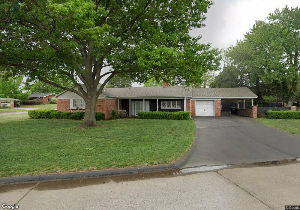
1511 Pearl St Duncan, OK 73533
Estimated Value: $161,000 - $193,960
3
Beds
2
Baths
1,975
Sq Ft
$88/Sq Ft
Est. Value
About This Home
This home is located at 1511 Pearl St, Duncan, OK 73533 and is currently estimated at $173,990, approximately $88 per square foot. 1511 Pearl St is a home located in Stephens County with nearby schools including Plato Elementary School, Duncan Middle School, and Duncan High School.
Ownership History
Date
Name
Owned For
Owner Type
Purchase Details
Closed on
Mar 21, 2025
Sold by
Barnes C H
Bought by
Reames Tracy and Reames Warren T
Current Estimated Value
Home Financials for this Owner
Home Financials are based on the most recent Mortgage that was taken out on this home.
Original Mortgage
$137,489
Outstanding Balance
$131,798
Interest Rate
6.89%
Mortgage Type
New Conventional
Estimated Equity
$42,192
Purchase Details
Closed on
Dec 19, 2001
Sold by
Barnes C H
Purchase Details
Closed on
Nov 17, 2000
Sold by
Barnes Ch and Barnes Patricia
Purchase Details
Closed on
Aug 27, 1993
Sold by
Connally Thomas W
Create a Home Valuation Report for This Property
The Home Valuation Report is an in-depth analysis detailing your home's value as well as a comparison with similar homes in the area
Home Values in the Area
Average Home Value in this Area
Purchase History
| Date | Buyer | Sale Price | Title Company |
|---|---|---|---|
| Reames Tracy | $165,000 | None Listed On Document | |
| -- | -- | -- | |
| -- | -- | -- | |
| -- | $75,000 | -- |
Source: Public Records
Mortgage History
| Date | Status | Borrower | Loan Amount |
|---|---|---|---|
| Open | Reames Tracy | $137,489 |
Source: Public Records
Tax History Compared to Growth
Tax History
| Year | Tax Paid | Tax Assessment Tax Assessment Total Assessment is a certain percentage of the fair market value that is determined by local assessors to be the total taxable value of land and additions on the property. | Land | Improvement |
|---|---|---|---|---|
| 2025 | $934 | $12,325 | $1,124 | $11,201 |
| 2024 | $934 | $11,967 | $1,124 | $10,843 |
| 2023 | $934 | $11,618 | $1,124 | $10,494 |
| 2022 | $902 | $11,609 | $1,124 | $10,485 |
| 2021 | $925 | $11,870 | $1,124 | $10,746 |
| 2020 | $898 | $11,405 | $1,100 | $10,305 |
| 2019 | $871 | $11,072 | $1,031 | $10,041 |
| 2018 | $868 | $11,072 | $1,031 | $10,041 |
| 2017 | $811 | $10,751 | $983 | $9,768 |
| 2016 | $776 | $10,133 | $924 | $9,209 |
| 2015 | $701 | $9,838 | $901 | $8,937 |
| 2014 | $701 | $9,551 | $878 | $8,673 |
Source: Public Records
Map
Nearby Homes
- 1404 1404 Ne Aspen
- 1405 Evergreen Dr
- 1402 1402 W Elk Ave
- 1527 1527 N 13th
- 1508 1508 N 13th St
- 1601 1601 Pearl
- 1107 W Elk Ave
- 1412 N 12th St
- 1706 Windsor Dr
- 1311 1311 N 20 St
- 1202 N Grand Blvd
- 2108 W Club Rd
- 2110 W Club Rd
- 1114 N 13th St
- 1302 N 21st St
- 1807 W Chisholm Dr
- 1902 W Randall Ave
- 1212 1212 N 21st
- 2120 2120 Flamingo Ln
- 1105 N Grand Blvd
- 1403 Wisteria Ave
- 1405 Wisteria Ave
- 1515 Pearl St
- 1512 Pearl St
- 1406 Wisteria Ave
- 1514 Pearl St
- 1404 Wisteria Ave
- 1408 Wisteria Ave
- 1404 Aspen Ave
- 1516 Pearl St
- 1407 Wisteria Ave
- 1509 Pearl St
- 1410 Wisteria Ave
- 1406 Aspen Ave
- 1518 Pearl St
- 1409 Wisteria Ave
- 1405 1405 Evergreen Dr
- 1403 Evergreen Dr
- 1408 Aspen Ave
- 1401 Evergreen Dr