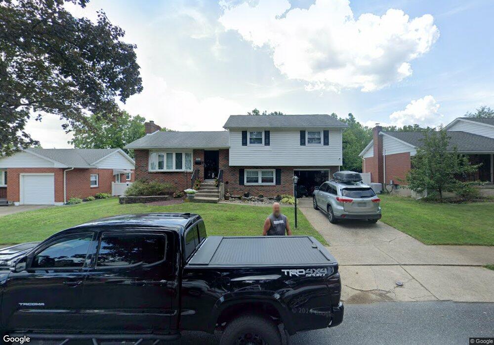
1511 Stanford Rd Bethlehem, PA 18018
West Bethlehem NeighborhoodEstimated Value: $324,000 - $420,000
3
Beds
2
Baths
1,590
Sq Ft
$238/Sq Ft
Est. Value
About This Home
This home is located at 1511 Stanford Rd, Bethlehem, PA 18018 and is currently estimated at $378,880, approximately $238 per square foot. 1511 Stanford Rd is a home located in Lehigh County with nearby schools including James Buchanan Elementary School, Nitschmann Middle School, and Liberty High School.
Ownership History
Date
Name
Owned For
Owner Type
Purchase Details
Closed on
Nov 20, 2012
Sold by
Fedor Joseph J
Bought by
Labar Ryan
Current Estimated Value
Home Financials for this Owner
Home Financials are based on the most recent Mortgage that was taken out on this home.
Original Mortgage
$110,000
Outstanding Balance
$76,120
Interest Rate
3.42%
Mortgage Type
New Conventional
Estimated Equity
$302,760
Purchase Details
Closed on
May 25, 1965
Bought by
Fedor Joseph J and Fedor Ruth R
Create a Home Valuation Report for This Property
The Home Valuation Report is an in-depth analysis detailing your home's value as well as a comparison with similar homes in the area
Home Values in the Area
Average Home Value in this Area
Purchase History
| Date | Buyer | Sale Price | Title Company |
|---|---|---|---|
| Labar Ryan | $150,000 | -- | |
| Fedor Joseph J | $3,000 | -- |
Source: Public Records
Mortgage History
| Date | Status | Borrower | Loan Amount |
|---|---|---|---|
| Open | Labar Ryan | $110,000 |
Source: Public Records
Tax History Compared to Growth
Tax History
| Year | Tax Paid | Tax Assessment Tax Assessment Total Assessment is a certain percentage of the fair market value that is determined by local assessors to be the total taxable value of land and additions on the property. | Land | Improvement |
|---|---|---|---|---|
| 2025 | $5,128 | $178,500 | $31,100 | $147,400 |
| 2024 | $5,069 | $178,500 | $31,100 | $147,400 |
| 2023 | $5,025 | $178,500 | $31,100 | $147,400 |
| 2022 | $5,107 | $178,500 | $147,400 | $31,100 |
| 2021 | $5,084 | $178,500 | $31,100 | $147,400 |
| 2020 | $4,921 | $178,500 | $31,100 | $147,400 |
| 2019 | $4,957 | $178,500 | $31,100 | $147,400 |
| 2018 | $4,861 | $178,500 | $31,100 | $147,400 |
| 2017 | $4,645 | $178,500 | $31,100 | $147,400 |
| 2016 | -- | $178,500 | $31,100 | $147,400 |
| 2015 | -- | $178,500 | $31,100 | $147,400 |
| 2014 | -- | $177,400 | $31,100 | $146,300 |
Source: Public Records
Map
Nearby Homes
- 1541 Stanford Rd
- 1011 Highland Ave
- 934 Highland Ave
- 1768 W Union Blvd
- 1334 W Union Blvd
- 922 Beverly Ave
- 650 Highland Ave
- 1309 Greenview Dr
- 1440 Greenview Dr
- 1853 Richmond Ave
- 1512 W Broad St
- 635 11th Ave
- 1209 Manchester Rd
- 1559 Kelchner Rd
- 1336 Greenview Dr
- 1918 Pinehurst Rd
- 1198 Pennsylvania Ave
- 1247 Birchwood Dr
- 1556 Bayberry Ln
- 2035 W Broad St
- 1517 Stanford Rd
- 1523 Stanford Rd
- 1477 Stanford Rd
- 1512 Stanford Rd
- 2020 Shelbourne Dr
- 1504 Stanford Rd
- 1518 Stanford Rd
- 1465 Stanford Rd
- 1529 Stanford Rd
- 1459 Dalehurst Dr
- 1460 Dalehurst Dr
- 1459 Stanford Rd
- 1539 Shelbourne Dr
- 1536 Stanford Rd
- 1529 Shelbourne Dr
- 1458 Stanford Rd
- 1452 Dalehurst Dr
- 1453 Stanford Rd
- 1449 Dalehurst Dr
- 1521 Shelbourne Dr