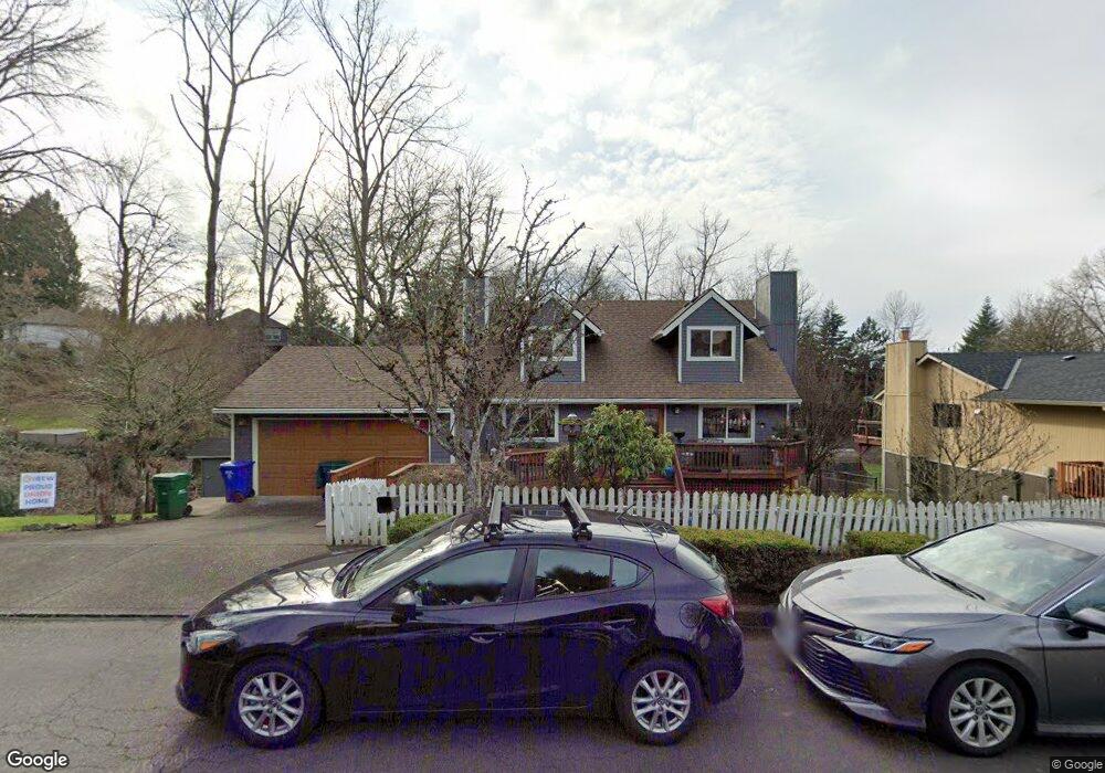
1511 SW Chastain Ave Gresham, OR 97080
Gresham Butte NeighborhoodEstimated Value: $526,000 - $602,000
4
Beds
3
Baths
1,600
Sq Ft
$350/Sq Ft
Est. Value
About This Home
This home is located at 1511 SW Chastain Ave, Gresham, OR 97080 and is currently estimated at $560,170, approximately $350 per square foot. 1511 SW Chastain Ave is a home located in Multnomah County with nearby schools including Dexter McCarty Middle School, Gresham High School, and Gresham Arthur Academy.
Ownership History
Date
Name
Owned For
Owner Type
Purchase Details
Closed on
Apr 1, 2022
Sold by
Cooke Bob J
Bought by
Cooke Family Trust
Current Estimated Value
Purchase Details
Closed on
May 2, 2011
Sold by
Cooke Bob
Bought by
Cooke Bob and Cooke Karen E
Home Financials for this Owner
Home Financials are based on the most recent Mortgage that was taken out on this home.
Original Mortgage
$224,523
Interest Rate
4.77%
Mortgage Type
FHA
Create a Home Valuation Report for This Property
The Home Valuation Report is an in-depth analysis detailing your home's value as well as a comparison with similar homes in the area
Home Values in the Area
Average Home Value in this Area
Purchase History
| Date | Buyer | Sale Price | Title Company |
|---|---|---|---|
| Cooke Family Trust | -- | None Listed On Document | |
| Cooke Bob | -- | Ticor Title |
Source: Public Records
Mortgage History
| Date | Status | Borrower | Loan Amount |
|---|---|---|---|
| Previous Owner | Cooke Bob | $224,523 |
Source: Public Records
Tax History
| Year | Tax Paid | Tax Assessment Tax Assessment Total Assessment is a certain percentage of the fair market value that is determined by local assessors to be the total taxable value of land and additions on the property. | Land | Improvement |
|---|---|---|---|---|
| 2025 | $6,674 | $327,980 | -- | -- |
| 2024 | $6,389 | $318,430 | -- | -- |
| 2023 | $5,821 | $309,160 | $0 | $0 |
| 2022 | $5,658 | $300,160 | $0 | $0 |
| 2021 | $5,516 | $291,420 | $0 | $0 |
| 2020 | $5,190 | $282,940 | $0 | $0 |
| 2019 | $5,054 | $274,700 | $0 | $0 |
| 2018 | $4,819 | $266,700 | $0 | $0 |
| 2017 | $4,623 | $258,940 | $0 | $0 |
| 2016 | $4,076 | $251,400 | $0 | $0 |
Source: Public Records
Map
Nearby Homes
- 1472 SW 14th St
- 1488 SW 17th Ct Unit N
- 1488 SW 17th Ct
- 1175 SW Chastain Dr
- 1829 SW 17th St
- 1859 SW Angeline Ave
- 1333 SW 19th Dr
- 1960 SW 13th Ct
- 1880 SW Heiney Rd
- 1441 SW 23rd Ct
- 1261 SW Binford Lake Pkwy
- 1407 SW Walters Dr
- 2520 SW Towle Ave
- 1278 SW 27th Ct
- 0 SW Miller Ct Unit 470855683
- 159 SW Florence Ave Unit 64
- 159 SW Florence Ave
- 1963 SW Myers Place
- 44 SW Birdsdale Dr
- 3120 SW Orchard Place
- 1503 SW Chastain Ave
- 1326 SW 15th Ct
- 1415 SW Chastain Ave
- 1327 SW 15th Ct
- 1417 SW 17th Ct
- 1312 SW 15th Ct
- 1409 SW Chastain Ave
- 1315 SW 15th Ct
- 1306 SW 15th Ct
- 1427 SW 17th Ct
- 1506 SW Towle Ave
- 1418 SW 17th Ct
- 1303 SW 15th Ct
- 1432 SW Towle Ave
- 1530 SW Towle Ave Unit 1534
- 1444 SW 14th St
- 1436 SW 14th St
- 1458 SW 14th St
- 1422 SW 14th St
- 1511 SW Wallula Dr
Your Personal Tour Guide
Ask me questions while you tour the home.