Estimated Value: $557,000 - $608,000
5
Beds
4
Baths
2,229
Sq Ft
$262/Sq Ft
Est. Value
About This Home
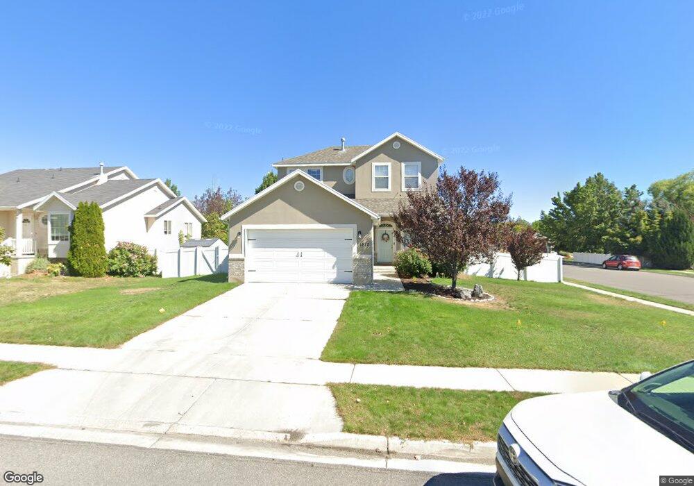
This home is located at 1512 N 250 W, Lehi, UT 84043 and is currently estimated at $583,358, approximately $261 per square foot. 1512 N 250 W is a home located in Utah County with nearby schools including Sego Lily Elementary School, Lehi Junior High School, and Skyridge High School.
Ownership History
Date
Name
Owned For
Owner Type
Purchase Details
Closed on
Jul 28, 2022
Sold by
Edwin Connors Seth
Bought by
Connors Living Trust
Current Estimated Value
Purchase Details
Closed on
Sep 10, 2018
Sold by
Handy Nathan Benjamin and Handy Robin Marie
Bought by
Connors Seth and Connors Leslie
Home Financials for this Owner
Home Financials are based on the most recent Mortgage that was taken out on this home.
Original Mortgage
$255,000
Interest Rate
4.5%
Mortgage Type
Purchase Money Mortgage
Purchase Details
Closed on
Aug 26, 2016
Sold by
Handy Nathan and Handy Robin Marie
Bought by
Handy Nathan Benjamin and Handy Robin Marie
Home Financials for this Owner
Home Financials are based on the most recent Mortgage that was taken out on this home.
Original Mortgage
$211,500
Interest Rate
3.48%
Mortgage Type
New Conventional
Purchase Details
Closed on
Apr 26, 2013
Sold by
Paystrup Emily M and Paystrup Nathan C
Bought by
Handy Nathan and Halter Robin
Home Financials for this Owner
Home Financials are based on the most recent Mortgage that was taken out on this home.
Original Mortgage
$223,003
Interest Rate
3.6%
Mortgage Type
New Conventional
Purchase Details
Closed on
Mar 26, 2012
Sold by
Tobler Emily M and Paystrup Emily M
Bought by
Paystrup Emily M and Paystrup Nathan C
Home Financials for this Owner
Home Financials are based on the most recent Mortgage that was taken out on this home.
Original Mortgage
$178,500
Interest Rate
3.83%
Mortgage Type
New Conventional
Purchase Details
Closed on
Apr 13, 2007
Sold by
Moren Monique
Bought by
Tobler Emily M and Paystrup Nathan C
Home Financials for this Owner
Home Financials are based on the most recent Mortgage that was taken out on this home.
Original Mortgage
$222,500
Interest Rate
6.1%
Mortgage Type
Purchase Money Mortgage
Purchase Details
Closed on
Mar 11, 2004
Sold by
Salisbury Development Lc
Bought by
Moren Monique
Home Financials for this Owner
Home Financials are based on the most recent Mortgage that was taken out on this home.
Original Mortgage
$161,000
Interest Rate
3.75%
Mortgage Type
Purchase Money Mortgage
Create a Home Valuation Report for This Property
The Home Valuation Report is an in-depth analysis detailing your home's value as well as a comparison with similar homes in the area
Home Values in the Area
Average Home Value in this Area
Purchase History
| Date | Buyer | Sale Price | Title Company |
|---|---|---|---|
| Connors Living Trust | -- | None Listed On Document | |
| Connors Seth | -- | Us Title Insurance Agency | |
| Handy Nathan Benjamin | -- | Fidelity National Agency So | |
| Handy Nathan | -- | Utah First Title Insurance A | |
| Paystrup Emily M | -- | None Available | |
| Tobler Emily M | -- | Equity Title Insurance Agen | |
| Moren Monique | -- | Provo Land Title Co |
Source: Public Records
Mortgage History
| Date | Status | Borrower | Loan Amount |
|---|---|---|---|
| Previous Owner | Connors Seth | $255,000 | |
| Previous Owner | Handy Nathan Benjamin | $211,500 | |
| Previous Owner | Handy Nathan | $223,003 | |
| Previous Owner | Paystrup Emily M | $178,500 | |
| Previous Owner | Tobler Emily M | $222,500 | |
| Previous Owner | Moren Monique | $161,000 |
Source: Public Records
Tax History Compared to Growth
Tax History
| Year | Tax Paid | Tax Assessment Tax Assessment Total Assessment is a certain percentage of the fair market value that is determined by local assessors to be the total taxable value of land and additions on the property. | Land | Improvement |
|---|---|---|---|---|
| 2025 | $2,214 | $283,580 | $208,000 | $307,600 |
| 2024 | $2,214 | $259,050 | $0 | $0 |
| 2023 | $2,075 | $263,670 | $0 | $0 |
| 2022 | $2,308 | $284,350 | $0 | $0 |
| 2021 | $2,066 | $384,800 | $120,400 | $264,400 |
| 2020 | $1,948 | $358,600 | $111,500 | $247,100 |
| 2019 | $1,758 | $336,400 | $111,500 | $224,900 |
| 2018 | $1,686 | $305,100 | $97,600 | $207,500 |
| 2017 | $1,525 | $146,685 | $0 | $0 |
| 2016 | $1,536 | $137,060 | $0 | $0 |
| 2015 | $1,528 | $129,415 | $0 | $0 |
| 2014 | $1,465 | $123,365 | $0 | $0 |
Source: Public Records
Map
Nearby Homes
- 1755 N 250 W
- 1329 N 100 E Unit 21
- 1150 N 200 W Unit 6
- 1295 N 190 E
- 4333 N Baiken Ridge Dr Unit 1020
- 996 N 200 W
- 155 W State St Unit TRLR 3
- 1817 W Bad Rock Cir
- 68 W State St
- 902 W 1500 N
- 1301 N 900 W Unit 12
- 497 W 2200 N
- 7 E State St
- 595 W 2200 N
- 443 W 820 N
- 1011 W Mountain Way Unit 316
- 497 W 2280 N
- 1094 W 1425 N
- 1610 N 1125 W
- 192 E 2200 N