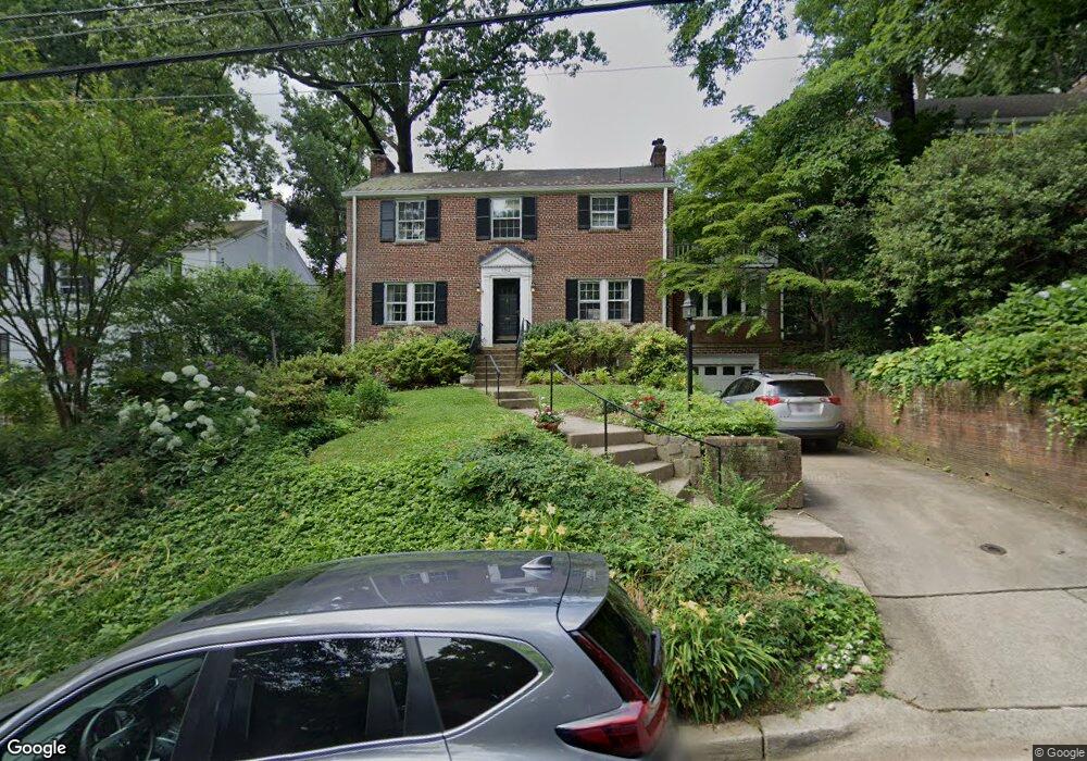
1512 Red Oak Dr Silver Spring, MD 20910
Estimated Value: $844,235 - $949,000
--
Bed
4
Baths
1,970
Sq Ft
$461/Sq Ft
Est. Value
About This Home
This home is located at 1512 Red Oak Dr, Silver Spring, MD 20910 and is currently estimated at $907,559, approximately $460 per square foot. 1512 Red Oak Dr is a home located in Montgomery County with nearby schools including Woodlin Elementary School, Sligo Middle School, and Albert Einstein High School.
Ownership History
Date
Name
Owned For
Owner Type
Purchase Details
Closed on
Mar 31, 2025
Sold by
Mutti Anne Worth and Abramson Jeffrey A
Bought by
Abramson & Mutti Joint Revocable Trust and Abramson
Current Estimated Value
Purchase Details
Closed on
Feb 21, 2003
Sold by
Mischler Paul B and Mischler F L
Bought by
Mutti Anne W and Abramson Jeffrey A
Purchase Details
Closed on
Nov 3, 1999
Sold by
King Anthony and King A
Bought by
Mischler Paul B and Mischler F L
Purchase Details
Closed on
Dec 15, 1994
Sold by
Rahtjen Donald B
Bought by
King Anthony
Home Financials for this Owner
Home Financials are based on the most recent Mortgage that was taken out on this home.
Original Mortgage
$313,500
Interest Rate
9.03%
Create a Home Valuation Report for This Property
The Home Valuation Report is an in-depth analysis detailing your home's value as well as a comparison with similar homes in the area
Home Values in the Area
Average Home Value in this Area
Purchase History
| Date | Buyer | Sale Price | Title Company |
|---|---|---|---|
| Abramson & Mutti Joint Revocable Trust | -- | None Listed On Document | |
| Abramson & Mutti Joint Revocable Trust | -- | None Listed On Document | |
| Mutti Anne W | $475,000 | -- | |
| Mischler Paul B | $345,000 | -- | |
| King Anthony | $330,000 | -- |
Source: Public Records
Mortgage History
| Date | Status | Borrower | Loan Amount |
|---|---|---|---|
| Previous Owner | King Anthony | $313,500 |
Source: Public Records
Tax History Compared to Growth
Tax History
| Year | Tax Paid | Tax Assessment Tax Assessment Total Assessment is a certain percentage of the fair market value that is determined by local assessors to be the total taxable value of land and additions on the property. | Land | Improvement |
|---|---|---|---|---|
| 2025 | $9,347 | $774,300 | -- | -- |
| 2024 | $9,347 | $748,400 | $346,000 | $402,400 |
| 2023 | $8,162 | $707,400 | $0 | $0 |
| 2022 | $7,315 | $666,400 | $0 | $0 |
| 2021 | $6,761 | $625,400 | $346,000 | $279,400 |
| 2020 | $6,761 | $625,400 | $346,000 | $279,400 |
| 2019 | $6,725 | $625,400 | $346,000 | $279,400 |
| 2018 | $6,771 | $631,300 | $309,800 | $321,500 |
| 2017 | $6,706 | $615,200 | $0 | $0 |
| 2016 | -- | $599,100 | $0 | $0 |
| 2015 | $5,667 | $583,000 | $0 | $0 |
| 2014 | $5,667 | $572,800 | $0 | $0 |
Source: Public Records
Map
Nearby Homes
- 1514 Red Oak Dr
- 1432 Crestridge Dr
- 1412 Crestridge Dr
- 1409 Crestridge Dr
- 1513 Flora Ln
- 9700 Dameron Dr
- 8920 Courts Way
- 1102 Dale Dr
- 1202 Burton St
- 709 Greyrock Dr
- 1935 Lyttonsville Rd
- 9207 Colesville Rd
- 9800 Georgia Ave Unit 25301
- 9624 Brunett Ave
- 1900 Lyttonsville Rd
- 1900 Lyttonsville Rd
- 1900 Lyttonsville Rd Unit 602
- 1900 Lyttonsville Rd
- 1900 Lyttonsville Rd
- 1900 Lyttonsville Rd Unit P96
- 1510 Red Oak Dr
- 1508 Red Oak Dr
- 1518 Red Oak Dr
- 1513 Live Oak Dr
- 1511 Live Oak Dr
- 1515 Live Oak Dr
- 1507 Live Oak Dr
- 1515 Red Oak Dr
- 1517 Live Oak Dr
- 1504 Red Oak Dr
- 1520 Red Oak Dr
- 1513 Red Oak Dr
- 1517 Red Oak Dr
- 1511 Red Oak Dr
- 1505 Live Oak Dr
- 1519 Red Oak Dr
- 1519 Live Oak Dr
- 1502 Red Oak Dr
- 1522 Red Oak Dr
- 1509 Red Oak Dr