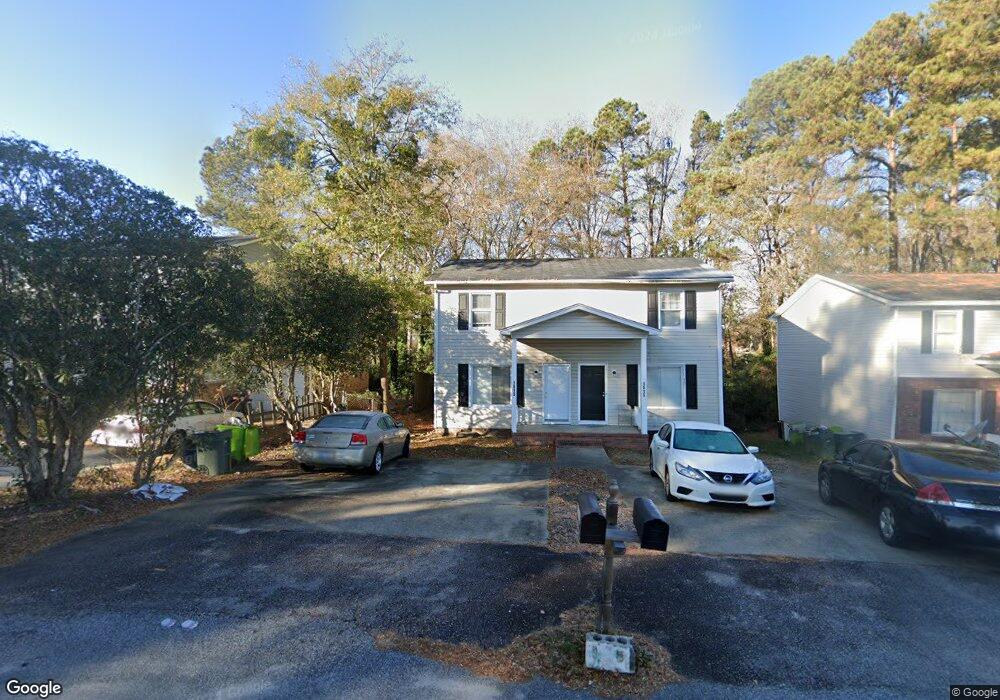
1513 Kathleen Dr Unit 5 Columbia, SC 29210
Saint Andrews NeighborhoodEstimated Value: $175,000 - $207,000
4
Beds
3
Baths
2,600
Sq Ft
$72/Sq Ft
Est. Value
About This Home
This home is located at 1513 Kathleen Dr Unit 5, Columbia, SC 29210 and is currently estimated at $187,889, approximately $72 per square foot. 1513 Kathleen Dr Unit 5 is a home located in Richland County with nearby schools including Sandel Elementary School, St. Andrews Middle School, and Columbia High School.
Ownership History
Date
Name
Owned For
Owner Type
Purchase Details
Closed on
Mar 8, 2018
Sold by
Beatty Bruce A
Bought by
A & M Properties Of S C Inc
Current Estimated Value
Purchase Details
Closed on
Jul 11, 2002
Sold by
Tapp Peggy C
Bought by
Beatty Bruce A
Home Financials for this Owner
Home Financials are based on the most recent Mortgage that was taken out on this home.
Original Mortgage
$73,600
Interest Rate
6.75%
Create a Home Valuation Report for This Property
The Home Valuation Report is an in-depth analysis detailing your home's value as well as a comparison with similar homes in the area
Home Values in the Area
Average Home Value in this Area
Purchase History
| Date | Buyer | Sale Price | Title Company |
|---|---|---|---|
| A & M Properties Of S C Inc | -- | None Available | |
| Beatty Bruce A | $92,000 | -- |
Source: Public Records
Mortgage History
| Date | Status | Borrower | Loan Amount |
|---|---|---|---|
| Previous Owner | Beatty Bruce A | $73,600 |
Source: Public Records
Tax History Compared to Growth
Tax History
| Year | Tax Paid | Tax Assessment Tax Assessment Total Assessment is a certain percentage of the fair market value that is determined by local assessors to be the total taxable value of land and additions on the property. | Land | Improvement |
|---|---|---|---|---|
| 2024 | $2,489 | $65,200 | $0 | $0 |
| 2023 | $2,422 | $0 | $0 | $0 |
| 2022 | $2,217 | $56,700 | $11,200 | $45,500 |
| 2021 | $2,174 | $3,400 | $0 | $0 |
| 2020 | $2,182 | $3,400 | $0 | $0 |
| 2019 | $1,807 | $3,400 | $0 | $0 |
| 2018 | $1,855 | $2,960 | $0 | $0 |
| 2017 | $1,814 | $2,960 | $0 | $0 |
| 2016 | $1,789 | $2,960 | $0 | $0 |
| 2015 | $1,770 | $2,960 | $0 | $0 |
| 2014 | $1,743 | $49,300 | $0 | $0 |
| 2013 | -- | $2,960 | $0 | $0 |
Source: Public Records
Map
Nearby Homes
- 1533 Westchester Dr
- 1605 Kathleen Dr
- 1618 van Lingle Ave
- 1509 Nunamaker Dr
- 1825 Woodsboro Dr
- 1810 Saint Michaels Rd
- 1900 Rolling Hills Rd
- 1917 Kathleen Dr
- 1917 Chandler Ave
- 2135 Rolling Hills Rd
- 1204 Old Manor Rd
- 2114 Apple Valley Rd
- 2225 Hertford Dr
- 1101 Menlo Dr
- 2229 Hertford Dr
- 2006 Mary Hill Dr
- 104 Menlo Dr
- 101 Menlo Dr
- 506 Menlo Dr
- 2116 Chandler Ave
- 1509 Kathleen Dr
- 1517 Kathleen Dr
- 1521 Kathleen Dr
- 1621 Westchester Dr Unit 1627
- 1621 Westchester Dr
- 1525 Kathleen Dr Unit 7
- 1529 Kathleen Dr
- 1611 Westchester Dr Unit 3
- 1601 Westchester Dr
- 1537 Kathleen Dr Unit 9
- 1700 Westchester Dr
- 202 Luther Rd
- 1513 Farrington Way
- 1539 Westchester Dr
- 1541 Kathleen Dr
- 1541 Kathleen Dr Unit 3
- 1541 Kathleen Dr
- 5 Ambrose Cir
- 1714 Whiteford Rd
- 1704 Westchester Dr