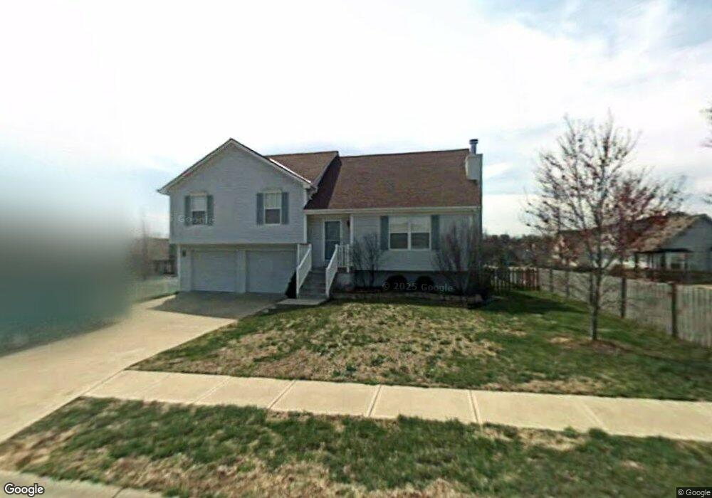
1513 NE Savoy Lees Summit, MO 64086
Lee's Summit AreaEstimated Value: $315,000 - $321,214
About This Home
This home is located at 1513 NE Savoy, Lees Summit, MO 64086 and is currently estimated at $318,054, approximately $248 per square foot. 1513 NE Savoy is a home located in Jackson County with nearby schools including Underwood Elementary School, Bernard C. Campbell Middle School, and Lee's Summit North High School.
Ownership History
We collect this data history from publicly available records. To have your information removed, we recommend requesting removal directly through your county’s website.
Purchase Details
Home Financials for this Owner
Home Financials are based on the most recent Mortgage that was taken out on this home.Purchase Details
Home Values in the Area
Average Home Value in this Area
Purchase History
We collect this data history from publicly available records. To have your information removed, we recommend requesting removal directly through your county’s website.
| Date | Buyer | Sale Price | Title Company |
|---|---|---|---|
| -- | Kansas City Title | ||
| -- | Security Land Title Company |
Mortgage History
We collect this data history from publicly available records. To have your information removed, we recommend requesting removal directly through your county’s website.
| Date | Status | Borrower | Loan Amount |
|---|---|---|---|
| Open | $212,500 | ||
| Closed | $120,000 |
Tax History
We collect this data history from publicly available records. To have your information removed, we recommend requesting removal directly through your county’s website.
| Year | Tax Paid | Tax Assessment Tax Assessment Total Assessment is a certain percentage of the fair market value that is determined by local assessors to be the total taxable value of land and additions on the property. | Land | Improvement |
|---|---|---|---|---|
| 2025 | $2,960 | $44,475 | $7,585 | $36,890 |
| 2024 | $2,938 | $40,993 | $7,277 | $33,716 |
| 2023 | $2,938 | $40,992 | $6,855 | $34,137 |
| 2022 | $2,715 | $33,630 | $4,352 | $29,278 |
| 2021 | $2,771 | $33,630 | $4,352 | $29,278 |
| 2020 | $2,611 | $31,384 | $4,352 | $27,032 |
| 2019 | $2,540 | $31,384 | $4,352 | $27,032 |
| 2018 | $2,382 | $27,315 | $3,788 | $23,527 |
| 2017 | $2,382 | $27,315 | $3,788 | $23,527 |
| 2016 | $2,384 | $27,056 | $4,047 | $23,009 |
| 2014 | $2,225 | $24,749 | $4,044 | $20,705 |
Map
- 1512 NE Savoy
- 1108 NE Colleen Dr
- 1301 NE Horizon Dr
- 1612 NE Bluff St
- 1700 NE Bluff St
- 1708 NE Bluff St
- 1029 NE Copperwood Dr
- 1231 NE Deerbrook Cir
- 1029 NE Brookfield Dr
- 1416 NE Ernest Way
- 1412 NE Ernest Way
- 1829 NE Riley Dr
- 1144 NE Hunters Ridge
- 1100 NE Deerbrook Terrace
- 1824 NE Woodview Ln
- 1536 NE Jade St
- 717 NE Ball Dr
- 1210 NE Richardson Place
- 617 NE Birchwood Dr
- 1008 NE Remington Ct
- 1125 NE Bryant Dr
- 1136 NE Colleen Dr
- 1121 NE Bryant Dr
- 1508 NE Savoy
- 1132 NE Colleen Dr
- 1124 NE Colleen Dr
- 1116 NE Colleen Dr
- 1117 NE Bryant Dr
- 1124 NE Bryant Dr
- 1204 NE Colleen Dr
- 1137 NE Colleen Dr
- 1133 NE Colleen Dr
- 1120 NE Bryant Dr
- 1205 NE Bryant Cir
- 1141 NE Colleen Dr
- 1200 NE Bryant Cir
- 1129 NE Colleen Dr
- 1201 NE Colleen Dr
- 1116 NE Bryant Dr
- 1100 NE Colleen Dr
Ask me questions while you tour the home.