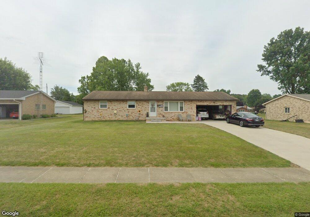
1516 Opal St Louisville, OH 44641
Estimated Value: $206,374 - $235,000
3
Beds
2
Baths
1,196
Sq Ft
$189/Sq Ft
Est. Value
About This Home
This home is located at 1516 Opal St, Louisville, OH 44641 and is currently estimated at $226,594, approximately $189 per square foot. 1516 Opal St is a home located in Stark County with nearby schools including Louisville High School and St. Thomas Aquinas High School & Middle School.
Ownership History
Date
Name
Owned For
Owner Type
Purchase Details
Closed on
May 20, 2020
Sold by
Smith Randy L
Bought by
Selby Randy A and Selby Peggy
Current Estimated Value
Home Financials for this Owner
Home Financials are based on the most recent Mortgage that was taken out on this home.
Original Mortgage
$147,000
Interest Rate
3.3%
Mortgage Type
New Conventional
Purchase Details
Closed on
Oct 31, 2019
Sold by
Dewalt Adam K and Dewalt Amy
Bought by
Smith Randy L
Purchase Details
Closed on
Sep 17, 2018
Sold by
Dewalt Laura M
Bought by
Dewalt Adam K
Create a Home Valuation Report for This Property
The Home Valuation Report is an in-depth analysis detailing your home's value as well as a comparison with similar homes in the area
Home Values in the Area
Average Home Value in this Area
Purchase History
| Date | Buyer | Sale Price | Title Company |
|---|---|---|---|
| Selby Randy A | $155,000 | None Available | |
| Smith Randy L | $80,000 | None Available | |
| Dewalt Adam K | -- | None Available |
Source: Public Records
Mortgage History
| Date | Status | Borrower | Loan Amount |
|---|---|---|---|
| Previous Owner | Selby Randy A | $147,000 |
Source: Public Records
Tax History Compared to Growth
Tax History
| Year | Tax Paid | Tax Assessment Tax Assessment Total Assessment is a certain percentage of the fair market value that is determined by local assessors to be the total taxable value of land and additions on the property. | Land | Improvement |
|---|---|---|---|---|
| 2025 | -- | $57,650 | $17,290 | $40,360 |
| 2024 | -- | $57,650 | $17,290 | $40,360 |
| 2023 | $2,291 | $53,310 | $16,310 | $37,000 |
| 2022 | $2,297 | $53,310 | $16,310 | $37,000 |
| 2021 | $2,303 | $53,310 | $16,310 | $37,000 |
| 2020 | $1,936 | $47,360 | $14,700 | $32,660 |
| 2019 | $1,892 | $47,360 | $14,700 | $32,660 |
| 2018 | $1,538 | $47,360 | $14,700 | $32,660 |
| 2017 | $1,389 | $42,390 | $12,920 | $29,470 |
| 2016 | $1,417 | $42,390 | $12,920 | $29,470 |
| 2015 | $1,421 | $42,390 | $12,920 | $29,470 |
| 2014 | $1,664 | $36,650 | $11,170 | $25,480 |
| 2013 | $836 | $36,650 | $11,170 | $25,480 |
Source: Public Records
Map
Nearby Homes
- 1715 High St
- 641 S Nickelplate St
- 1812 E Broad St
- 520 S Silver St
- 2110 Edmar St
- 308 Superior St
- 728 E Broad St
- 908 Sand Lot Cir
- 510 S Bauman Ct
- 0 Michigan Blvd
- 204 E Broad St
- 107 E Broad St
- 2015 E Main St
- 3390 Meese Rd NE
- 325 Lincoln Ave
- 1702 View Pointe Ave
- 1639 Horizon Dr
- 8225 Georgetown St
- 1170 Winding Ridge Ave
- 910 Crosswyck Cir