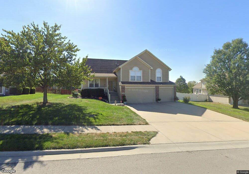
1517 Haystack Rd Raymore, MO 64083
Estimated Value: $415,056 - $430,000
4
Beds
3
Baths
1,792
Sq Ft
$235/Sq Ft
Est. Value
About This Home
This home is located at 1517 Haystack Rd, Raymore, MO 64083 and is currently estimated at $421,264, approximately $235 per square foot. 1517 Haystack Rd is a home located in Cass County with nearby schools including Stonegate Elementary School, Raymore-Peculiar South Middle School, and Raymore-Peculiar Senior High School.
Ownership History
Date
Name
Owned For
Owner Type
Purchase Details
Closed on
Aug 17, 2011
Sold by
Sexton William R and Sexton Linda D
Bought by
Nutt Keith R
Current Estimated Value
Home Financials for this Owner
Home Financials are based on the most recent Mortgage that was taken out on this home.
Original Mortgage
$125,250
Outstanding Balance
$8,102
Interest Rate
3.81%
Mortgage Type
New Conventional
Estimated Equity
$413,162
Create a Home Valuation Report for This Property
The Home Valuation Report is an in-depth analysis detailing your home's value as well as a comparison with similar homes in the area
Home Values in the Area
Average Home Value in this Area
Purchase History
| Date | Buyer | Sale Price | Title Company |
|---|---|---|---|
| Nutt Keith R | -- | Coffelt Land Title Inc |
Source: Public Records
Mortgage History
| Date | Status | Borrower | Loan Amount |
|---|---|---|---|
| Open | Nutt Keith R | $125,250 |
Source: Public Records
Tax History
| Year | Tax Paid | Tax Assessment Tax Assessment Total Assessment is a certain percentage of the fair market value that is determined by local assessors to be the total taxable value of land and additions on the property. | Land | Improvement |
|---|---|---|---|---|
| 2025 | $4,440 | $56,150 | $8,050 | $48,100 |
| 2024 | $4,440 | $49,700 | $7,320 | $42,380 |
| 2023 | $4,434 | $49,700 | $7,320 | $42,380 |
| 2022 | $4,011 | $44,200 | $7,320 | $36,880 |
| 2021 | $3,902 | $44,200 | $7,320 | $36,880 |
| 2020 | $3,878 | $43,130 | $7,320 | $35,810 |
| 2019 | $3,753 | $43,130 | $7,320 | $35,810 |
| 2018 | $3,473 | $38,280 | $6,100 | $32,180 |
| 2017 | $3,143 | $38,280 | $6,100 | $32,180 |
| 2016 | $3,143 | $35,940 | $6,100 | $29,840 |
| 2015 | $3,145 | $35,940 | $6,100 | $29,840 |
| 2014 | $3,147 | $35,940 | $6,100 | $29,840 |
| 2013 | -- | $35,940 | $6,100 | $29,840 |
Source: Public Records
Map
Nearby Homes
- 1309 Larkspur Place
- 1228 Larkspur Place
- 1301 Larkspur Place
- 1227 Larkspur Place
- 1408 Larkspur Place
- 1717 Overbrook Ln
- 1519 Colt Cir
- 1510 Colt Cir
- 1103 Carlisle Dr
- 1035 Mission Park Trail
- 1033 Mission Park Trail
- 1031 Mission Park Trail
- 1029 Mission Park Trail
- 1025 Mission Park Trail
- 1009 Balboa Trail
- 1105 Creekside Ct
- 1205 Sendera Trail
- 727 Country Ln
- 817 Clancy Ct
- 709 Bluestem Ct
- 1515 Haystack Rd
- 1519 Haystack Rd
- 1526 Deer Ridge Ct
- 937 Old Mill Rd
- 1513 Haystack Rd
- 1524 Deer Ridge Ct
- 934 Hedge Apple Place
- 933 Hedge Apple Place
- 1528 Deer Ridge Ct
- 1518 Haystack Rd
- 942 Selby Ct
- 1511 Haystack Rd
- 932 Hedge Apple Place
- 936 Old Mill Rd
- 934 Old Mill Rd
- 931 Hedge Apple Place
- 938 Old Mill Rd
- 1522 Deer Ridge Ct
- 938 Elder Ct
- 940 Old Mill Rd
Your Personal Tour Guide
Ask me questions while you tour the home.