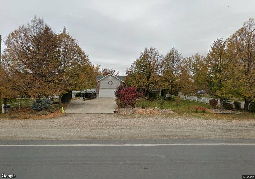
1517 S 4500 W Syracuse, UT 84075
Estimated Value: $620,000 - $776,000
4
Beds
3
Baths
3,218
Sq Ft
$215/Sq Ft
Est. Value
About This Home
This home is located at 1517 S 4500 W, Syracuse, UT 84075 and is currently estimated at $692,463, approximately $215 per square foot. 1517 S 4500 W is a home located in Davis County with nearby schools including Buffalo Point School, Syracuse Junior High School, and Syracuse High School.
Ownership History
Date
Name
Owned For
Owner Type
Purchase Details
Closed on
Nov 30, 2011
Sold by
Holt Darrell D and Holt Christine D
Bought by
Holtl Darrell Dwight and Holt Chrsitine D
Current Estimated Value
Purchase Details
Closed on
Jul 22, 2004
Sold by
Federal Home Loan Mortgage Corporation
Bought by
Holt Darrell D and Holt Christine D
Home Financials for this Owner
Home Financials are based on the most recent Mortgage that was taken out on this home.
Original Mortgage
$120,000
Interest Rate
5.8%
Mortgage Type
Purchase Money Mortgage
Purchase Details
Closed on
Mar 23, 2004
Sold by
Brangal Edward J and Brangal Lana J
Bought by
Federal Home Loan Mortgage Corporation
Create a Home Valuation Report for This Property
The Home Valuation Report is an in-depth analysis detailing your home's value as well as a comparison with similar homes in the area
Home Values in the Area
Average Home Value in this Area
Purchase History
| Date | Buyer | Sale Price | Title Company |
|---|---|---|---|
| Holtl Darrell Dwight | -- | None Available | |
| Holt Darrell D | -- | First American Title Co | |
| Federal Home Loan Mortgage Corporation | $198,406 | Backman Stewart Title Svcs |
Source: Public Records
Mortgage History
| Date | Status | Borrower | Loan Amount |
|---|---|---|---|
| Previous Owner | Holt Darrell D | $120,000 | |
| Closed | Holt Darrell D | $89,000 |
Source: Public Records
Tax History Compared to Growth
Tax History
| Year | Tax Paid | Tax Assessment Tax Assessment Total Assessment is a certain percentage of the fair market value that is determined by local assessors to be the total taxable value of land and additions on the property. | Land | Improvement |
|---|---|---|---|---|
| 2025 | $3,592 | $346,536 | $134,861 | $211,675 |
| 2024 | $3,545 | $344,322 | $136,756 | $207,566 |
| 2023 | $3,293 | $582,000 | $172,808 | $409,192 |
| 2022 | $3,616 | $350,351 | $103,571 | $246,780 |
| 2021 | $2,874 | $435,000 | $148,593 | $286,407 |
| 2020 | $2,603 | $378,000 | $141,535 | $236,465 |
| 2019 | $2,490 | $357,000 | $132,589 | $224,411 |
| 2018 | $2,298 | $327,000 | $122,326 | $204,674 |
| 2016 | $2,041 | $152,524 | $43,054 | $109,470 |
| 2015 | $1,717 | $122,219 | $43,054 | $79,165 |
| 2014 | $1,743 | $126,390 | $42,687 | $83,703 |
| 2013 | -- | $119,795 | $46,854 | $72,941 |
Source: Public Records
Map
Nearby Homes
- 4580 W 1700 S
- 4191 W 1425 S
- 1238 S 4290 W
- 1155 S 4475 W
- 1157 S 4425 W
- 1139 S 4475 W
- 1125 S 4475 W
- 4578 W 1150 S
- 1141 S 4700 W
- 1068 S 4425 W
- 4468 W 1050 S
- Bradford Plan at Harvest Fields
- Avery Plan at Harvest Fields
- Sullivan Plan at Harvest Fields
- Presley Plan at Harvest Fields
- Ashmore Plan at Harvest Fields
- Bridgeport Plan at Harvest Fields
- Malan Plan at Harvest Fields
- Havenwood Plan at Harvest Fields
- Hamilton Plan at Harvest Fields
- 1501 S 4500 W
- 1509 S 4500 W
- 1554 S 4500 W
- 1483 S 4500 W
- 1567 S 4500 W
- 1567 S 4500 W Unit 8
- 1461 S 4500 W
- 1555 S 4500 W
- 4440 W 1550 S
- 4523 W Frary Rd Unit 101
- 4523 W Frary Rd
- 1587 S 4500 W
- 4449 W 1425 S Unit 204
- 4449 W 1425 S
- 4543 W Frary Rd
- 4387 W 1550 S
- 4387 W 1550 S Unit 24
- 1605 S 4500 W
- 4380 W 1550 S
- 4431 W 1425 S