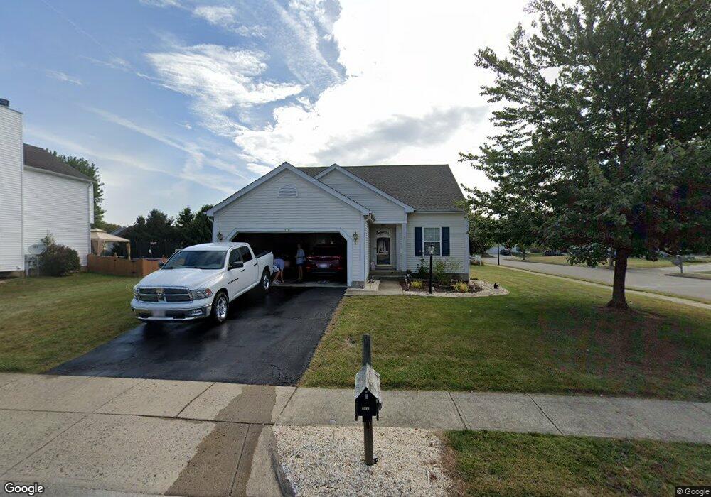
1518 Mallard Cir E Newark, OH 43055
Estimated Value: $348,000 - $383,000
3
Beds
3
Baths
2,491
Sq Ft
$145/Sq Ft
Est. Value
About This Home
This home is located at 1518 Mallard Cir E, Newark, OH 43055 and is currently estimated at $361,940, approximately $145 per square foot. 1518 Mallard Cir E is a home located in Licking County with nearby schools including Legend Elementary School, Liberty Middle School, and Newark High School.
Ownership History
Date
Name
Owned For
Owner Type
Purchase Details
Closed on
Nov 14, 2001
Sold by
M/I Schottenstein Homes
Bought by
Booher Thomas M and Booher Patricia A
Current Estimated Value
Home Financials for this Owner
Home Financials are based on the most recent Mortgage that was taken out on this home.
Original Mortgage
$152,650
Outstanding Balance
$59,531
Interest Rate
6.69%
Mortgage Type
New Conventional
Estimated Equity
$302,409
Create a Home Valuation Report for This Property
The Home Valuation Report is an in-depth analysis detailing your home's value as well as a comparison with similar homes in the area
Home Values in the Area
Average Home Value in this Area
Purchase History
| Date | Buyer | Sale Price | Title Company |
|---|---|---|---|
| Booher Thomas M | $169,650 | -- |
Source: Public Records
Mortgage History
| Date | Status | Borrower | Loan Amount |
|---|---|---|---|
| Open | Booher Thomas M | $152,650 |
Source: Public Records
Tax History Compared to Growth
Tax History
| Year | Tax Paid | Tax Assessment Tax Assessment Total Assessment is a certain percentage of the fair market value that is determined by local assessors to be the total taxable value of land and additions on the property. | Land | Improvement |
|---|---|---|---|---|
| 2024 | $3,072 | $95,730 | $21,000 | $74,730 |
| 2023 | $3,089 | $95,730 | $21,000 | $74,730 |
| 2022 | $2,774 | $69,230 | $14,700 | $54,530 |
| 2021 | $2,909 | $69,230 | $14,700 | $54,530 |
| 2020 | $2,978 | $69,230 | $14,700 | $54,530 |
| 2019 | $2,801 | $62,760 | $12,250 | $50,510 |
| 2018 | $2,803 | $0 | $0 | $0 |
| 2017 | $2,565 | $0 | $0 | $0 |
| 2016 | $2,393 | $0 | $0 | $0 |
| 2015 | $2,445 | $0 | $0 | $0 |
| 2014 | $3,133 | $0 | $0 | $0 |
| 2013 | $2,393 | $0 | $0 | $0 |
Source: Public Records
Map
Nearby Homes
- 395 Quail Run Ct
- 437 Hunters Ct
- 1631 W Turkey Run Dr
- 1649 W Turkey Run Dr
- 1345 Sherwood Downs Rd W
- 1831 Churchill Downs Rd
- 1738 Scioto Way
- 1684 Churchill Downs Rd
- 1821 Mount Vernon Rd
- 105 Pimlico Ave
- 139 Aqueduct Ave
- 336 Myrtle Ave
- 1954 Iselin St
- 1644 Mt Vernon Rd
- 1948 Jamesburg St
- 1993 Iselin St
- 1981 Iselin St
- 1949 Iselin St
- 1957 Iselin St
- 1973 Iselin St
- 1524 Mallard Cir E
- 1524 Mallard Cir E Unit 2516
- 0 Mallard Dr Unit 2498 2223004
- 0 Mallard Dr Unit 2494 2222989
- 0 Mallard Dr Unit 2516 2222992
- 0 Mallard Dr Unit 2513
- 1517 S Hunters Dr
- 335 Mallard Dr
- 1523 S Hunters Dr
- 1523 S Hunters Dr Unit 2519
- 1530 Mallard Cir E
- 341 Mallard Dr
- 341 Mallard Dr Unit 2493
- 1519 Mallard Cir E
- 1519 Mallard Cir E Unit 2555
- 347 Mallard Dr
- 1529 S Hunters Dr
- 1501 S Hunters Dr
- 1525 Mallard Cir E
- 0 S Hunters Dr Unit 2489 2222993