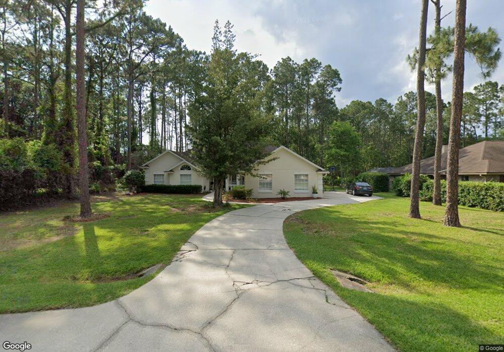
1518 Mallard Landing Blvd Saint Johns, FL 32259
Estimated Value: $570,924 - $651,000
4
Beds
2
Baths
2,647
Sq Ft
$236/Sq Ft
Est. Value
About This Home
This home is located at 1518 Mallard Landing Blvd, Saint Johns, FL 32259 and is currently estimated at $624,981, approximately $236 per square foot. 1518 Mallard Landing Blvd is a home located in St. Johns County with nearby schools including Cunningham Creek Elementary School, Switzerland Point Middle School, and Bartram Trail High School.
Ownership History
Date
Name
Owned For
Owner Type
Purchase Details
Closed on
Nov 4, 2013
Sold by
Dunbar Harold S and Wells Fargo Bank Na
Bought by
Hinson Properties Llc
Current Estimated Value
Purchase Details
Closed on
Feb 19, 2002
Sold by
Depietto Donald and Depietto Jill A
Bought by
Dunbar Harold S and Dunbar Deborah H
Home Financials for this Owner
Home Financials are based on the most recent Mortgage that was taken out on this home.
Original Mortgage
$214,700
Interest Rate
6.81%
Create a Home Valuation Report for This Property
The Home Valuation Report is an in-depth analysis detailing your home's value as well as a comparison with similar homes in the area
Home Values in the Area
Average Home Value in this Area
Purchase History
| Date | Buyer | Sale Price | Title Company |
|---|---|---|---|
| Hinson Properties Llc | $246,200 | None Available | |
| Dunbar Harold S | $226,000 | -- |
Source: Public Records
Mortgage History
| Date | Status | Borrower | Loan Amount |
|---|---|---|---|
| Previous Owner | Dunbar Harold S | $214,700 |
Source: Public Records
Tax History Compared to Growth
Tax History
| Year | Tax Paid | Tax Assessment Tax Assessment Total Assessment is a certain percentage of the fair market value that is determined by local assessors to be the total taxable value of land and additions on the property. | Land | Improvement |
|---|---|---|---|---|
| 2025 | $5,692 | $483,783 | -- | -- |
| 2024 | $5,692 | $477,513 | $130,000 | $347,513 |
| 2023 | $5,692 | $466,864 | $140,000 | $326,864 |
| 2022 | $5,409 | $458,487 | $145,600 | $312,887 |
| 2021 | $4,578 | $330,431 | $0 | $0 |
| 2020 | $4,388 | $315,657 | $0 | $0 |
| 2019 | $4,158 | $281,449 | $0 | $0 |
| 2018 | $3,969 | $265,305 | $0 | $0 |
| 2017 | $3,826 | $250,319 | $53,000 | $197,319 |
| 2016 | $3,830 | $242,324 | $0 | $0 |
| 2015 | $3,834 | $237,209 | $0 | $0 |
| 2014 | $3,744 | $228,329 | $0 | $0 |
Source: Public Records
Map
Nearby Homes
- 540 Roberts Rd
- 1722 Heatherwood Dr
- 1500 State Road 13 N
- 2407 Hawkcrest Dr E
- 1161 Dover Dr
- 1304 Hideaway Dr S
- 1145 Dover Dr
- 1242 Wild Turkey Ct
- 1285 Scott Rd
- 1837 Fairfax Ct S
- 1221 Creekwood Way S
- 256 Village Green Ave
- 1128 Mill Creek Dr
- 129 Hunters Creek Dr
- 284 Queen Victoria Ave
- 1192 Perregrine Cir W
- 144 Nottingham Dr E
- 1290 Cunningham Creek Dr
- 623 Hampton Downs Ct
- 0 Lee Rd Unit 2057637
- 1514 Mallard Landing Blvd
- 1519 Mallard Landing Blvd
- 700 Roberts Rd
- 690 Roberts Rd
- 1515 Mallard Landing Blvd
- 720 Roberts St
- 1510 Mallard Landing Blvd
- 720 Roberts Rd
- 680 Roberts Rd
- 1511 Mallard Landing Blvd
- 1506 Mallard Landing Blvd
- 660
- 660 Roberts Rd (Bonus)
- 660 Roberts Rd
- 730 Roberts Rd
- 1507 Mallard Landing Blvd
- 1502 Mallard Landing Blvd
- 1503 Mallard Landing Blvd
- 650 Roberts Rd
- 740 Roberts Rd