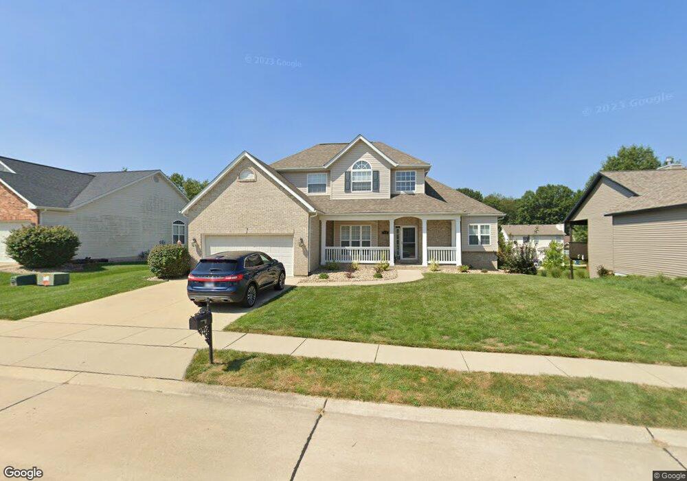
1519 Coles Ct Edwardsville, IL 62025
Estimated Value: $401,046 - $464,000
4
Beds
3
Baths
2,474
Sq Ft
$177/Sq Ft
Est. Value
About This Home
This home is located at 1519 Coles Ct, Edwardsville, IL 62025 and is currently estimated at $436,762, approximately $176 per square foot. 1519 Coles Ct is a home located in Madison County with nearby schools including LeClaire Elementary School, Columbus Elementary School, and Liberty Middle School.
Ownership History
Date
Name
Owned For
Owner Type
Purchase Details
Closed on
Jul 26, 2012
Sold by
Terfehr Douglas J and Terfehr Christina R
Bought by
Dresner Michael E and Dresner Robin L
Current Estimated Value
Home Financials for this Owner
Home Financials are based on the most recent Mortgage that was taken out on this home.
Original Mortgage
$196,400
Interest Rate
3.57%
Mortgage Type
New Conventional
Purchase Details
Closed on
Sep 12, 2005
Sold by
Prime Development Inc
Bought by
Terfehr Douglas J and Terfehr Christina R
Home Financials for this Owner
Home Financials are based on the most recent Mortgage that was taken out on this home.
Original Mortgage
$254,600
Interest Rate
5%
Mortgage Type
Fannie Mae Freddie Mac
Create a Home Valuation Report for This Property
The Home Valuation Report is an in-depth analysis detailing your home's value as well as a comparison with similar homes in the area
Home Values in the Area
Average Home Value in this Area
Purchase History
| Date | Buyer | Sale Price | Title Company |
|---|---|---|---|
| Dresner Michael E | $245,500 | None Available | |
| Terfehr Douglas J | $290,000 | Guaranty Title Co |
Source: Public Records
Mortgage History
| Date | Status | Borrower | Loan Amount |
|---|---|---|---|
| Previous Owner | Dresner Michael E | $196,400 | |
| Previous Owner | Terfehr Douglas J | $254,600 |
Source: Public Records
Tax History Compared to Growth
Tax History
| Year | Tax Paid | Tax Assessment Tax Assessment Total Assessment is a certain percentage of the fair market value that is determined by local assessors to be the total taxable value of land and additions on the property. | Land | Improvement |
|---|---|---|---|---|
| 2024 | $8,905 | $125,960 | $19,150 | $106,810 |
| 2023 | $8,905 | $115,040 | $17,490 | $97,550 |
| 2022 | $8,201 | $104,310 | $15,860 | $88,450 |
| 2021 | $7,190 | $98,610 | $14,990 | $83,620 |
| 2020 | $6,936 | $95,210 | $14,470 | $80,740 |
| 2019 | $6,901 | $93,770 | $14,250 | $79,520 |
| 2018 | $6,743 | $88,230 | $13,410 | $74,820 |
| 2017 | $6,500 | $85,210 | $12,950 | $72,260 |
| 2016 | $5,825 | $85,210 | $12,950 | $72,260 |
| 2015 | $5,809 | $82,450 | $12,530 | $69,920 |
| 2014 | $5,809 | $82,450 | $12,530 | $69,920 |
| 2013 | $5,809 | $82,450 | $12,530 | $69,920 |
Source: Public Records
Map
Nearby Homes
- 0 Governor's Way Unit 23019948
- Culpepper Plan at Governor's Way
- Scarlett Plan at Governor's Way
- Bella Plan at Governor's Way
- Titan Plan at Governor's Way
- Sunrise Plan at Governor's Way
- Winchester B Plan at Governor's Way
- Alexandria Plan at Governor's Way
- Herndon Plan at Governor's Way
- Bristol Plan at Governor's Way
- Hannah Plan at Governor's Way
- Covington Plan at Governor's Way
- Winchester A Plan at Governor's Way
- Covington 2 Car Plan at Governor's Way
- Brady Plan at Governor's Way
- Bristol Villa Plan at Governor's Way
- 3478 Manassas Dr
- 18 Shiloh Ct
- 112 Chattanooga Ct
- 116 Surrey Ln
- 1515 Coles Ct
- 1523 Coles Ct
- 1576 Maplewood Ct
- 1580 Maplewood Ct
- 1511 Coles Ct
- 1520 N Coles Ct
- 1516 Coles Ct
- 1512 Coles Ct
- 1520 Coles Ct
- 1507 Coles Ct
- 1508 Coles Ct
- 1601 Coles Ct
- 1602 Maplewood Ct
- 1574 Maplewood Ct
- 1579 Maplewood Ct
- 1581 Maplewood Ct
- 1523 Oglesby Dr
- 1600 Coles Ct
- 1577 Maplewood Ct
- 1504 Coles Ct