Estimated Value: $173,000 - $212,000
3
Beds
2
Baths
1,405
Sq Ft
$135/Sq Ft
Est. Value
About This Home
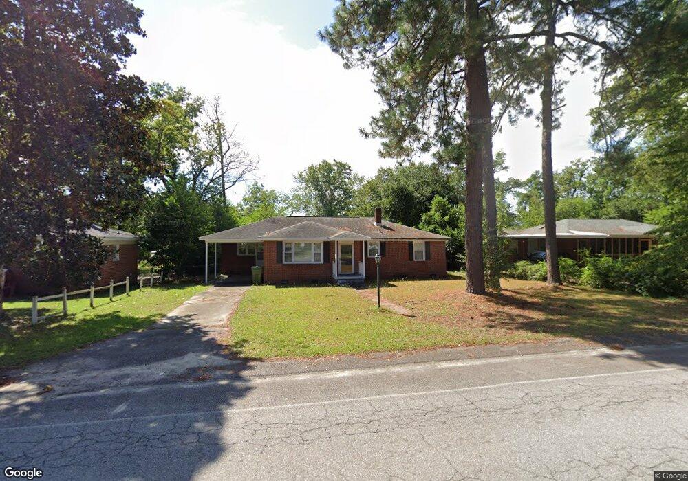
This home is located at 1519 Dunbar Rd, Cayce, SC 29033 and is currently estimated at $189,722, approximately $135 per square foot. 1519 Dunbar Rd is a home located in Lexington County with nearby schools including Cayce Elementary, Cyril B. Busbee Creative Arts Academy, and Brookland-Cayce High School.
Ownership History
Date
Name
Owned For
Owner Type
Purchase Details
Closed on
Mar 29, 2011
Sold by
Us Bank National Asociation
Bought by
Asee Carl
Current Estimated Value
Home Financials for this Owner
Home Financials are based on the most recent Mortgage that was taken out on this home.
Original Mortgage
$68,225
Interest Rate
4.87%
Mortgage Type
FHA
Purchase Details
Closed on
Oct 25, 2010
Sold by
Mooney Robert G and Mooney Sheryl D
Bought by
Us Bank National Association
Purchase Details
Closed on
Aug 19, 1998
Sold by
Grubb Joel D
Bought by
Stoudemire Sheryl D
Create a Home Valuation Report for This Property
The Home Valuation Report is an in-depth analysis detailing your home's value as well as a comparison with similar homes in the area
Home Values in the Area
Average Home Value in this Area
Purchase History
| Date | Buyer | Sale Price | Title Company |
|---|---|---|---|
| Asee Carl | $70,000 | -- | |
| Us Bank National Association | $82,000 | -- | |
| Stoudemire Sheryl D | $60,000 | -- |
Source: Public Records
Mortgage History
| Date | Status | Borrower | Loan Amount |
|---|---|---|---|
| Previous Owner | Asee Carl | $68,225 |
Source: Public Records
Tax History
| Year | Tax Paid | Tax Assessment Tax Assessment Total Assessment is a certain percentage of the fair market value that is determined by local assessors to be the total taxable value of land and additions on the property. | Land | Improvement |
|---|---|---|---|---|
| 2024 | $1,993 | $4,767 | $1,107 | $3,660 |
| 2023 | $1,832 | $4,767 | $1,107 | $3,660 |
| 2022 | $1,713 | $4,767 | $1,107 | $3,660 |
| 2020 | $1,635 | $4,767 | $1,107 | $3,660 |
| 2019 | $1,438 | $4,145 | $1,200 | $2,945 |
| 2018 | $1,409 | $4,145 | $1,200 | $2,945 |
| 2017 | $1,388 | $4,145 | $1,200 | $2,945 |
| 2016 | $1,395 | $4,144 | $1,200 | $2,944 |
| 2014 | $1,385 | $4,798 | $1,200 | $3,598 |
| 2013 | -- | $4,800 | $1,200 | $3,600 |
Source: Public Records
Map
Nearby Homes
- Dunbar II Plan at Dunbar Village
- 0 Benedict St
- 1414 Hazel St
- 1515 Benedict St
- 117 Odell Dr
- 121 Odell Dr
- 129 Odell Dr
- 133 Odell Dr
- 000 Frink St
- 1731 Chadsworth Dr
- 1805 Chadsworth Dr
- 2312 Lucas St
- TBD Poplar Lots A B & C St
- 1604 Northland Dr
- 1804 13th St
- 1832 Wadsworth Dr
- 1818 Sunnyside Dr
- 1137 Allen St
- 1512 Summerland Dr
- 1855 Evelyn St
Your Personal Tour Guide
Ask me questions while you tour the home.