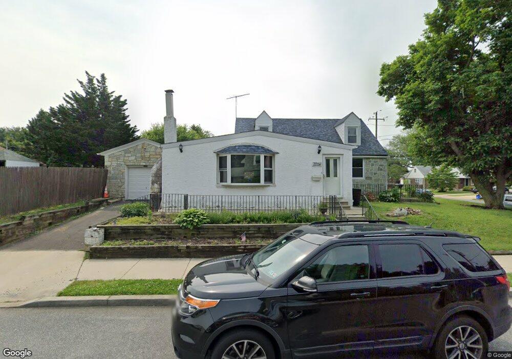
1519 Rhawn St Philadelphia, PA 19111
Rhawnhurst NeighborhoodEstimated Value: $401,000 - $463,000
--
Bed
1
Bath
1,707
Sq Ft
$251/Sq Ft
Est. Value
About This Home
This home is located at 1519 Rhawn St, Philadelphia, PA 19111 and is currently estimated at $427,707, approximately $250 per square foot. 1519 Rhawn St is a home located in Philadelphia County with nearby schools including Farrell Louis H School, Northeast High School, and Tacony Academy Charter School.
Ownership History
Date
Name
Owned For
Owner Type
Purchase Details
Closed on
Jan 15, 2008
Sold by
Gallie Jeffrey F and Gallie Lisa M
Bought by
Criollo Jose L
Current Estimated Value
Home Financials for this Owner
Home Financials are based on the most recent Mortgage that was taken out on this home.
Original Mortgage
$256,400
Outstanding Balance
$161,929
Interest Rate
6.17%
Mortgage Type
Purchase Money Mortgage
Estimated Equity
$265,778
Purchase Details
Closed on
Nov 30, 1995
Sold by
Nasevich Michael P and Washart Kathleen P
Bought by
Gallie Jeffrey F and Gallie Lisa M
Create a Home Valuation Report for This Property
The Home Valuation Report is an in-depth analysis detailing your home's value as well as a comparison with similar homes in the area
Home Values in the Area
Average Home Value in this Area
Purchase History
| Date | Buyer | Sale Price | Title Company |
|---|---|---|---|
| Criollo Jose L | $269,900 | None Available | |
| Gallie Jeffrey F | $116,000 | -- |
Source: Public Records
Mortgage History
| Date | Status | Borrower | Loan Amount |
|---|---|---|---|
| Open | Criollo Jose L | $256,400 |
Source: Public Records
Tax History Compared to Growth
Tax History
| Year | Tax Paid | Tax Assessment Tax Assessment Total Assessment is a certain percentage of the fair market value that is determined by local assessors to be the total taxable value of land and additions on the property. | Land | Improvement |
|---|---|---|---|---|
| 2025 | $4,380 | $391,100 | $78,220 | $312,880 |
| 2024 | $4,380 | $391,100 | $78,220 | $312,880 |
| 2023 | $4,380 | $312,900 | $62,580 | $250,320 |
| 2022 | $3,130 | $267,900 | $62,580 | $205,320 |
| 2021 | $3,760 | $0 | $0 | $0 |
| 2020 | $3,760 | $0 | $0 | $0 |
| 2019 | $3,641 | $0 | $0 | $0 |
| 2018 | $2,899 | $0 | $0 | $0 |
| 2017 | $3,319 | $0 | $0 | $0 |
| 2016 | $2,899 | $0 | $0 | $0 |
| 2015 | $2,775 | $0 | $0 | $0 |
| 2014 | -- | $237,100 | $173,173 | $63,927 |
| 2012 | -- | $25,536 | $9,932 | $15,604 |
Source: Public Records
Map
Nearby Homes
- 1443 Rhawn St
- 1625 Rhawn St
- 8127 Langdon St
- 1704 Stanwood St
- 1617 Solly Ave
- 1620 Loney St
- 1702 Arthur St
- 7900 Algon Ave Unit A
- 1718 Rhawn St
- 1627 Rhawn St
- 1719 Loney St
- 1705 Solly Ave
- 1627 Borbeck Ave
- 7830 Summerdale Ave
- 7836 Lorna Dr
- 7831 Lorna Dr
- 7735 Langdon St
- 7734 Langdon St
- 1200 Stanwood St
- 7804 Whitaker Ave