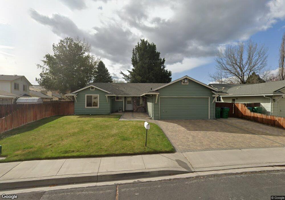
1519 Topeka Cir Sparks, NV 89434
Reed NeighborhoodEstimated Value: $461,919 - $496,000
3
Beds
2
Baths
1,642
Sq Ft
$293/Sq Ft
Est. Value
About This Home
This home is located at 1519 Topeka Cir, Sparks, NV 89434 and is currently estimated at $480,730, approximately $292 per square foot. 1519 Topeka Cir is a home located in Washoe County with nearby schools including Lloyd Diedrichsen Elementary School, Lou Mendive Middle School, and Edward C Reed High School.
Ownership History
Date
Name
Owned For
Owner Type
Purchase Details
Closed on
Nov 8, 2002
Sold by
Evans Michael P and Evans Diana L
Bought by
Evans Michael P and Evans Diana L
Current Estimated Value
Home Financials for this Owner
Home Financials are based on the most recent Mortgage that was taken out on this home.
Original Mortgage
$91,850
Interest Rate
5.95%
Create a Home Valuation Report for This Property
The Home Valuation Report is an in-depth analysis detailing your home's value as well as a comparison with similar homes in the area
Home Values in the Area
Average Home Value in this Area
Purchase History
| Date | Buyer | Sale Price | Title Company |
|---|---|---|---|
| Evans Michael P | -- | First American Title |
Source: Public Records
Mortgage History
| Date | Status | Borrower | Loan Amount |
|---|---|---|---|
| Closed | Evans Michael P | $91,850 |
Source: Public Records
Tax History Compared to Growth
Tax History
| Year | Tax Paid | Tax Assessment Tax Assessment Total Assessment is a certain percentage of the fair market value that is determined by local assessors to be the total taxable value of land and additions on the property. | Land | Improvement |
|---|---|---|---|---|
| 2026 | -- | $76,615 | $36,890 | $39,725 |
| 2025 | $2,000 | $77,096 | $36,120 | $40,976 |
| 2024 | $2,000 | $75,059 | $33,215 | $41,844 |
| 2023 | $1,944 | $75,207 | $35,175 | $40,032 |
| 2022 | $1,888 | $60,449 | $26,740 | $33,709 |
| 2021 | $1,834 | $55,691 | $21,735 | $33,956 |
| 2020 | $1,778 | $55,104 | $20,720 | $34,384 |
| 2019 | $1,726 | $54,270 | $20,720 | $33,550 |
| 2018 | $1,677 | $47,607 | $14,455 | $33,152 |
| 2017 | $1,629 | $47,215 | $13,720 | $33,495 |
| 2016 | $1,591 | $47,636 | $12,250 | $35,386 |
| 2015 | $408 | $45,955 | $10,325 | $35,630 |
| 2014 | $1,543 | $43,556 | $9,030 | $34,526 |
| 2013 | -- | $41,072 | $6,860 | $34,212 |
Source: Public Records
Map
Nearby Homes
- 1770 Burnside Dr
- 2002 Wabash Cir
- 2252 Sycamore Glen Dr
- 1866 Pocono Ct
- 1332 Coachman Ct
- 1990 Fargo Way
- 2688 Laguna Way
- 1280 O'Callaghan Dr
- 2119 Avella Dr
- 1290 Highgate Ct
- 2407 Sunny Slope Dr Unit 1
- 1757 Bluehaven Dr
- 2159 Meritage Dr
- 1544 Woodhaven Ln
- 1675 Round Mountain Cir
- 1005 Amico Dr
- 1218 Junction Dr
- 2679 Sycamore Glen Dr Unit 4
- 1960 Vicenza Dr
- 1973 Rio Tinto Dr
- 1529 Topeka Cir
- 2561 Wabash Cir
- 2571 Wabash Cir
- 1670 Wabash Ct
- 1675 Wabash Ct
- 2581 Wabash Cir
- 1533 Topeka Cir
- 2541 Wabash Cir
- 1518 Topeka Cir
- 2601 Wabash Cir
- 1660 Wabash Ct
- 1538 Topeka Cir
- 1665 Wabash Ct
- 1539 Topeka Cir
- 2537 Wabash Cir
- 1095 Locomotive Ct
- 2607 Wabash Cir
- 1568 Topeka Cir
- 2572 Wabash Cir
- 1091 Locomotive Ct