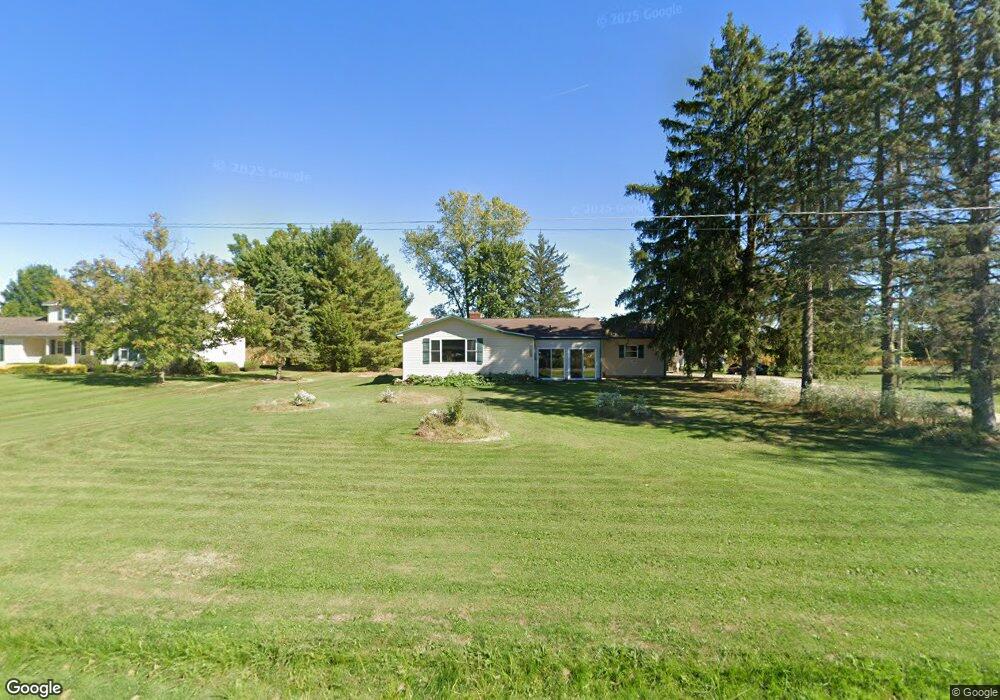
15191 Whitehead Rd Lagrange, OH 44050
Estimated Value: $225,586 - $255,000
3
Beds
3
Baths
1,096
Sq Ft
$223/Sq Ft
Est. Value
About This Home
This home is located at 15191 Whitehead Rd, Lagrange, OH 44050 and is currently estimated at $243,897, approximately $222 per square foot. 15191 Whitehead Rd is a home located in Lorain County with nearby schools including Keystone Elementary School, Keystone Middle School, and Keystone High School.
Ownership History
Date
Name
Owned For
Owner Type
Purchase Details
Closed on
Jul 24, 2007
Sold by
Meko Robert J and Meko Florence
Bought by
Smith Brian Ross and Smith Bethany Ann
Current Estimated Value
Home Financials for this Owner
Home Financials are based on the most recent Mortgage that was taken out on this home.
Original Mortgage
$115,000
Interest Rate
6.69%
Mortgage Type
Purchase Money Mortgage
Create a Home Valuation Report for This Property
The Home Valuation Report is an in-depth analysis detailing your home's value as well as a comparison with similar homes in the area
Home Values in the Area
Average Home Value in this Area
Purchase History
| Date | Buyer | Sale Price | Title Company |
|---|---|---|---|
| Smith Brian Ross | $115,000 | Attorney |
Source: Public Records
Mortgage History
| Date | Status | Borrower | Loan Amount |
|---|---|---|---|
| Closed | Smith Brian Ross | $115,000 |
Source: Public Records
Tax History
| Year | Tax Paid | Tax Assessment Tax Assessment Total Assessment is a certain percentage of the fair market value that is determined by local assessors to be the total taxable value of land and additions on the property. | Land | Improvement |
|---|---|---|---|---|
| 2024 | $2,908 | $70,599 | $17,787 | $52,812 |
| 2023 | $2,596 | $52,654 | $17,238 | $35,417 |
| 2022 | $2,577 | $52,654 | $17,238 | $35,417 |
| 2021 | $2,576 | $52,654 | $17,238 | $35,417 |
| 2020 | $2,280 | $41,490 | $13,580 | $27,910 |
| 2019 | $2,265 | $41,490 | $13,580 | $27,910 |
| 2018 | $2,266 | $41,490 | $13,580 | $27,910 |
| 2017 | $2,323 | $40,920 | $14,400 | $26,520 |
| 2016 | $2,306 | $40,920 | $14,400 | $26,520 |
| 2015 | $2,302 | $40,920 | $14,400 | $26,520 |
| 2014 | $1,891 | $38,600 | $13,580 | $25,020 |
| 2013 | $1,833 | $38,600 | $13,580 | $25,020 |
Source: Public Records
Map
Nearby Homes
- 340 Granger Dr
- 829 Robinson Dr
- 808 Buckingham Dr
- 800 Buckingham Dr
- 548 William St
- 516 Appomattox Ct
- 801 Willich Ct
- 607 Rundle St
- 305 W Main St
- 40175 Banks Rd
- 110 Railroad St
- 0 Dill Ct Unit 5072837
- 40163 Banks Rd
- 41341 Ravines Edge Way
- 43902 State Route 303
- 43915 State Route 511
- 16974 Hawley Rd
- 13301 Indian Hollow Rd
- 1033 Parsons Rd Unit 11
- 45336 Parsons Rd
- 15225 Whitehead Rd
- 15139 Whitehead Rd
- 15109 Whitehead Rd
- 14999 Whitehead Rd
- 15086 Whitehead Rd
- 41804 Rachael Dr
- 41766 Rachael Dr
- 41728 Rachael Dr
- 15038 Whitehead Rd
- 41690 Rachael Dr
- 15000 Whitehead Rd
- 41801 Rachael Dr
- 15450 Whitehead Rd
- 41725 Rachael Dr
- 14951 Whitehead Rd
- 41652 Rachael Dr
- 41687 Rachael Dr
- 41614 Rachael Dr
- 15505 Whitehead Rd
- 41649 Rachael Dr
Your Personal Tour Guide
Ask me questions while you tour the home.