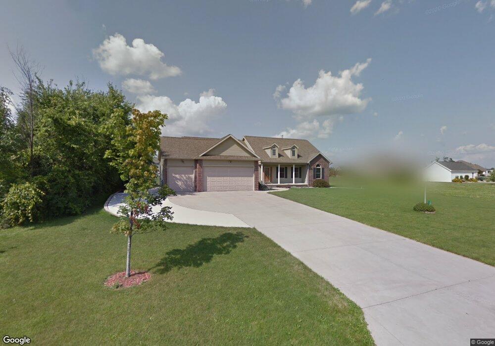
152 Clover Brook Dr Owosso, MI 48867
Estimated Value: $353,746 - $455,000
Studio
--
Bath
--
Sq Ft
23,174
Sq Ft Lot
About This Home
This home is located at 152 Clover Brook Dr, Owosso, MI 48867 and is currently estimated at $407,437. 152 Clover Brook Dr is a home located in Shiawassee County with nearby schools including Owosso High School, Owosso Sda School, and St. Paul School.
Ownership History
Date
Name
Owned For
Owner Type
Purchase Details
Closed on
Jun 27, 2014
Sold by
Ketchum Philip E and Ketchum Heather R
Bought by
Kramer Michael B
Current Estimated Value
Home Financials for this Owner
Home Financials are based on the most recent Mortgage that was taken out on this home.
Original Mortgage
$218,500
Outstanding Balance
$166,119
Interest Rate
4.11%
Mortgage Type
New Conventional
Estimated Equity
$241,318
Purchase Details
Closed on
Nov 9, 2012
Sold by
Compeau Michael T and Compeau Cindy S
Bought by
Ketchum Philip E and Hetchum Heather R
Home Financials for this Owner
Home Financials are based on the most recent Mortgage that was taken out on this home.
Original Mortgage
$216,015
Interest Rate
3.25%
Mortgage Type
FHA
Purchase Details
Closed on
Nov 24, 2004
Sold by
Ardelean L Robert and Ardelean Arlene M
Bought by
Compeau Michel T and Compeau Cindy S
Create a Home Valuation Report for This Property
The Home Valuation Report is an in-depth analysis detailing your home's value as well as a comparison with similar homes in the area
Home Values in the Area
Average Home Value in this Area
Purchase History
| Date | Buyer | Sale Price | Title Company |
|---|---|---|---|
| Kramer Michael B | $230,000 | -- | |
| Ketchum Philip E | $223,000 | -- | |
| Compeau Michel T | $37,000 | -- |
Source: Public Records
Mortgage History
| Date | Status | Borrower | Loan Amount |
|---|---|---|---|
| Open | Kramer Michael B | $218,500 | |
| Previous Owner | Ketchum Philip E | $216,015 |
Source: Public Records
Tax History
| Year | Tax Paid | Tax Assessment Tax Assessment Total Assessment is a certain percentage of the fair market value that is determined by local assessors to be the total taxable value of land and additions on the property. | Land | Improvement |
|---|---|---|---|---|
| 2025 | $3,832 | $186,000 | $0 | $0 |
| 2024 | $3,907 | $176,400 | $0 | $0 |
| 2023 | $1,429 | $164,700 | $0 | $0 |
| 2022 | $1,361 | $152,100 | $0 | $0 |
| 2021 | $3,453 | $147,700 | $0 | $0 |
| 2020 | $3,402 | $144,600 | $0 | $0 |
| 2019 | $3,339 | $128,700 | $0 | $0 |
| 2018 | $3,372 | $122,300 | $0 | $0 |
| 2017 | $2,724 | $113,800 | $0 | $0 |
| 2016 | -- | $113,800 | $0 | $0 |
| 2015 | -- | $102,800 | $0 | $0 |
| 2014 | $10 | $99,100 | $0 | $0 |
Source: Public Records
Map
Nearby Homes
- 2445 N Hickory Rd
- 2145 N M 52
- 553 W Wildwood Dr
- 570 W Wildwood Dr
- 502 Dean Dr
- 914 Chipman Ln
- 1218 N Water St
- 1119 Dingwall Dr
- 1200 N Dewey St
- 210 Stratford Dr
- 1021 Dingwall Dr
- 1473 Mallard Cir
- 1430 Mallard Cir
- 1270 N Chipman St
- 1431 Pintail Ct
- 1193 Hanover St
- 1475 N Water St
- 916 N Shiawassee St
- 815 Pine St
- 723 Adams St
- 152 Clover Brook Dr
- 2267 Burning Tree Cir
- 2121 Burning Tree Cir
- 2255 Burning Tree Cir
- 173 Clover Brook Dr
- 134 Clover Brook Dr
- 2195 Burning Tree Cir
- 2183 Burning Tree Cir
- 141 Clover Brook Dr
- 2247 Burning Tree Cir
- 2175 Burning Tree Cir
- 135 Clover Brook Dr
- 2256 Burning Tree Cir
- 2244 Burning Tree Cir
- 2112 Burning Tree Cir
- 2112 Burning
- 2100 Burning Tree Cir
- 160 W Wilkinson Rd
- 2124 Burning Tree Cir
- 182 W Wilkinson Rd
Your Personal Tour Guide
Ask me questions while you tour the home.