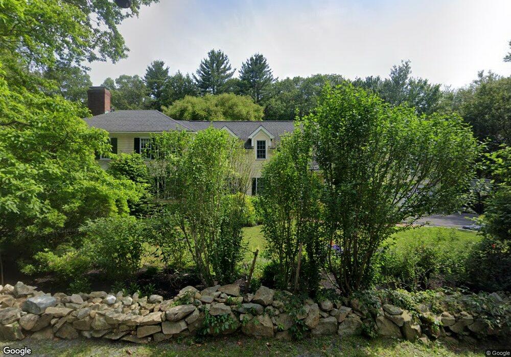
152 Grove St Westwood, MA 02090
Estimated Value: $2,885,627 - $3,288,000
5
Beds
5
Baths
5,732
Sq Ft
$542/Sq Ft
Est. Value
About This Home
This home is located at 152 Grove St, Westwood, MA 02090 and is currently estimated at $3,104,407, approximately $541 per square foot. 152 Grove St is a home located in Norfolk County with nearby schools including Westwood High School, The Rashi School, and St. Sebastian's School.
Ownership History
Date
Name
Owned For
Owner Type
Purchase Details
Closed on
May 30, 2014
Sold by
Garner Jeffrey S and Garner Donna H
Bought by
Tsipis Yanni and Kara Kristin
Current Estimated Value
Home Financials for this Owner
Home Financials are based on the most recent Mortgage that was taken out on this home.
Original Mortgage
$1,199,250
Outstanding Balance
$905,262
Interest Rate
4%
Mortgage Type
Purchase Money Mortgage
Estimated Equity
$2,199,145
Purchase Details
Closed on
Jun 9, 1997
Sold by
Hornbuckle Tr Michael
Bought by
Garner Jeffrey S and Garner Donna H
Home Financials for this Owner
Home Financials are based on the most recent Mortgage that was taken out on this home.
Original Mortgage
$840,000
Interest Rate
7.98%
Mortgage Type
Purchase Money Mortgage
Purchase Details
Closed on
Dec 20, 1996
Sold by
Layton John R and Layton Pamela G
Bought by
152 Grove St Etc
Create a Home Valuation Report for This Property
The Home Valuation Report is an in-depth analysis detailing your home's value as well as a comparison with similar homes in the area
Home Values in the Area
Average Home Value in this Area
Purchase History
| Date | Buyer | Sale Price | Title Company |
|---|---|---|---|
| Tsipis Yanni | $1,599,000 | -- | |
| Garner Jeffrey S | $1,050,000 | -- | |
| 152 Grove St Etc | $1,000,000 | -- |
Source: Public Records
Mortgage History
| Date | Status | Borrower | Loan Amount |
|---|---|---|---|
| Open | Tsipis Yanni | $1,199,250 | |
| Previous Owner | 152 Grove St Etc | $852,100 | |
| Previous Owner | 152 Grove St Etc | $840,000 |
Source: Public Records
Tax History Compared to Growth
Tax History
| Year | Tax Paid | Tax Assessment Tax Assessment Total Assessment is a certain percentage of the fair market value that is determined by local assessors to be the total taxable value of land and additions on the property. | Land | Improvement |
|---|---|---|---|---|
| 2025 | $31,626 | $2,470,800 | $1,153,700 | $1,317,100 |
| 2024 | $30,534 | $2,383,600 | $1,055,200 | $1,328,400 |
| 2023 | $27,703 | $1,937,300 | $938,200 | $999,100 |
| 2022 | $26,180 | $1,765,350 | $829,100 | $936,250 |
| 2021 | $26,056 | $1,762,950 | $793,100 | $969,850 |
| 2020 | $25,597 | $1,764,100 | $793,100 | $971,000 |
| 2019 | $24,503 | $1,672,550 | $758,700 | $913,850 |
| 2018 | $23,812 | $1,578,000 | $713,100 | $864,900 |
| 2017 | $23,166 | $1,590,000 | $713,100 | $876,900 |
| 2016 | $22,448 | $1,531,250 | $713,100 | $818,150 |
| 2015 | $21,698 | $1,423,750 | $713,100 | $710,650 |
Source: Public Records
Map
Nearby Homes
- 314 Grove St
- 429 Summer St
- 298 Summer St
- 300 Summer St
- 250 Meadowbrook Rd
- 262 Meadowbrook Rd
- 18 Longmeadow Dr
- 85 Schoolmaster Ln
- 20 Longmeadow Dr
- 223 Robert Rd
- 1133 High
- 1133 High St
- 26 Longmeadow Dr
- 175 Schoolmaster Ln
- 35 Shuttleworth Place
- 20 Shuttleworth Place
- 20-35 Shuttleworth Place
- 1040 High St
- 1032 High St
- 87 Horrigan Dr Unit 8