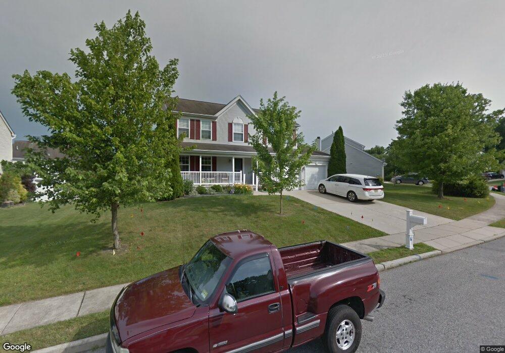
152 Landing Dr Woodbury, NJ 08096
Deptford Township NeighborhoodEstimated Value: $466,316 - $521,000
--
Bed
--
Bath
2,072
Sq Ft
$241/Sq Ft
Est. Value
About This Home
This home is located at 152 Landing Dr, Woodbury, NJ 08096 and is currently estimated at $499,579, approximately $241 per square foot. 152 Landing Dr is a home located in Gloucester County with nearby schools including Deptford Township High School, Holy Angels Catholic School, and St. Teresa Regional School.
Ownership History
Date
Name
Owned For
Owner Type
Purchase Details
Closed on
May 16, 2008
Sold by
Patel Mehul A and Patel Monica
Bought by
Alia Ronald F and Alia Danielle M
Current Estimated Value
Home Financials for this Owner
Home Financials are based on the most recent Mortgage that was taken out on this home.
Original Mortgage
$245,200
Outstanding Balance
$148,250
Interest Rate
5.03%
Mortgage Type
Purchase Money Mortgage
Estimated Equity
$351,329
Create a Home Valuation Report for This Property
The Home Valuation Report is an in-depth analysis detailing your home's value as well as a comparison with similar homes in the area
Home Values in the Area
Average Home Value in this Area
Purchase History
| Date | Buyer | Sale Price | Title Company |
|---|---|---|---|
| Alia Ronald F | $306,500 | Weichert Title Agency |
Source: Public Records
Mortgage History
| Date | Status | Borrower | Loan Amount |
|---|---|---|---|
| Open | Alia Ronald F | $245,200 |
Source: Public Records
Tax History Compared to Growth
Tax History
| Year | Tax Paid | Tax Assessment Tax Assessment Total Assessment is a certain percentage of the fair market value that is determined by local assessors to be the total taxable value of land and additions on the property. | Land | Improvement |
|---|---|---|---|---|
| 2025 | $9,307 | $259,600 | $46,600 | $213,000 |
| 2024 | $9,008 | $259,600 | $46,600 | $213,000 |
| 2023 | $9,008 | $259,600 | $46,600 | $213,000 |
| 2022 | $8,943 | $259,600 | $46,600 | $213,000 |
| 2021 | $8,816 | $259,600 | $46,600 | $213,000 |
| 2020 | $8,715 | $259,600 | $46,600 | $213,000 |
| 2019 | $8,549 | $259,600 | $46,600 | $213,000 |
| 2018 | $8,357 | $259,600 | $46,600 | $213,000 |
| 2017 | $8,133 | $259,600 | $46,600 | $213,000 |
| 2016 | $7,967 | $259,600 | $46,600 | $213,000 |
| 2015 | $7,721 | $259,600 | $46,600 | $213,000 |
| 2014 | $7,521 | $259,600 | $46,600 | $213,000 |
Source: Public Records
Map
Nearby Homes
- 340 Arline Ave
- 1240 Delsea Dr
- 622 Sweetgum Ln Unit 145
- 431 Dogwood Dr
- 416 Dogwood Dr
- 128 Pennsbury Ln
- 53 Knollwood Dr
- 54 Knollwood Dr
- 308 Winding Way Unit C8
- 715 Winding Way Unit G15
- 416 Winding Way
- 406 Winding Way
- 208 Chancellor Dr
- 341 Chancellor Dr
- 13 Yorktown Ct
- 140 Liberty Way
- 38 Pinecrest Dr
- 162 Liberty Way
- 1879 Delsea Dr
- 103 Carriage Way