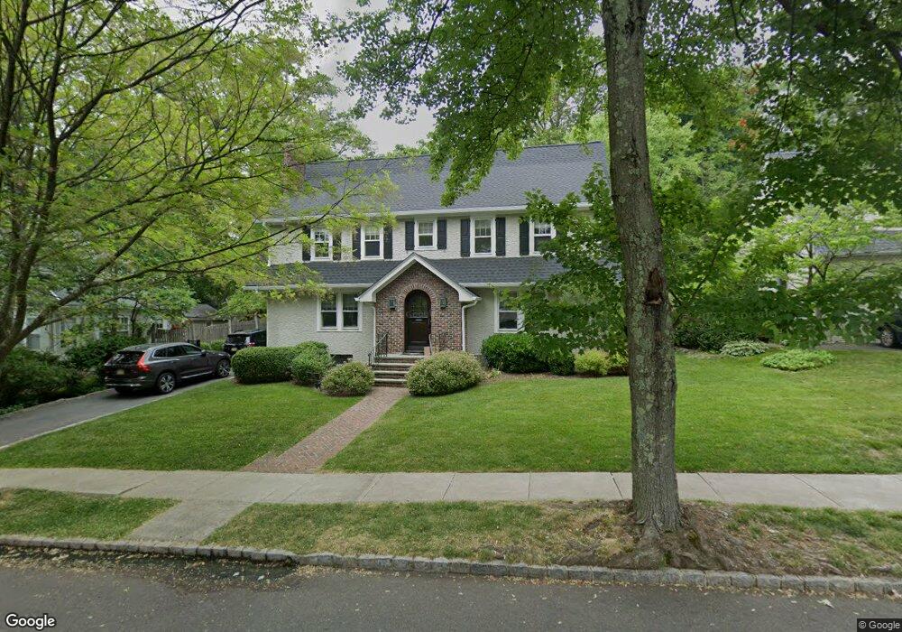
152 Maple St Summit, NJ 07901
Estimated Value: $1,846,143 - $2,099,000
Studio
--
Bath
3,091
Sq Ft
$645/Sq Ft
Est. Value
About This Home
This home is located at 152 Maple St, Summit, NJ 07901 and is currently estimated at $1,992,786, approximately $644 per square foot. 152 Maple St is a home located in Union County with nearby schools including L C Johnson Summit Middle School, Summit Sr High School, and Oak Knoll School of the Holy Child.
Ownership History
Date
Name
Owned For
Owner Type
Purchase Details
Closed on
Dec 7, 2001
Sold by
Cummings Whitley and Cummings Mary
Bought by
Fialcowitz John A and Fialcowitz Maureen F Baker
Current Estimated Value
Home Financials for this Owner
Home Financials are based on the most recent Mortgage that was taken out on this home.
Original Mortgage
$517,500
Outstanding Balance
$202,665
Interest Rate
6.6%
Estimated Equity
$1,790,121
Purchase Details
Closed on
Apr 20, 1994
Sold by
Murray Mike H
Bought by
Cummings Whitley and Cummings Mary
Home Financials for this Owner
Home Financials are based on the most recent Mortgage that was taken out on this home.
Original Mortgage
$300,000
Interest Rate
7.6%
Create a Home Valuation Report for This Property
The Home Valuation Report is an in-depth analysis detailing your home's value as well as a comparison with similar homes in the area
Home Values in the Area
Average Home Value in this Area
Purchase History
| Date | Buyer | Sale Price | Title Company |
|---|---|---|---|
| Fialcowitz John A | $690,000 | Chicago Title Insurance Co | |
| Cummings Whitley | $380,000 | -- |
Source: Public Records
Mortgage History
| Date | Status | Borrower | Loan Amount |
|---|---|---|---|
| Open | Fialcowitz John A | $517,500 | |
| Previous Owner | Cummings Whitley | $300,000 |
Source: Public Records
Tax History
| Year | Tax Paid | Tax Assessment Tax Assessment Total Assessment is a certain percentage of the fair market value that is determined by local assessors to be the total taxable value of land and additions on the property. | Land | Improvement |
|---|---|---|---|---|
| 2025 | $23,113 | $530,600 | $209,600 | $321,000 |
| 2024 | $22,959 | $530,600 | $209,600 | $321,000 |
| 2023 | $22,959 | $530,600 | $209,600 | $321,000 |
| 2022 | $22,726 | $530,600 | $209,600 | $321,000 |
| 2021 | $22,906 | $530,600 | $209,600 | $321,000 |
| 2020 | $23,134 | $530,600 | $209,600 | $321,000 |
| 2019 | $23,161 | $530,600 | $209,600 | $321,000 |
| 2018 | $23,012 | $530,600 | $209,600 | $321,000 |
| 2017 | $18,010 | $412,600 | $209,600 | $203,000 |
| 2016 | $17,746 | $412,600 | $209,600 | $203,000 |
| 2015 | $17,399 | $412,600 | $209,600 | $203,000 |
| 2014 | $16,950 | $412,600 | $209,600 | $203,000 |
Source: Public Records
Map
Nearby Homes
- 64 Tulip St
- 69 Elm St
- 67 Tulip St
- 61 Tulip St
- 40 Prospect St
- 80 Glenside Ave
- 105 Larned Rd
- 42 Locust Dr
- 4 Parkview Terrace
- 1 Baltusrol Place
- 28 Glenside Ave
- 84 Pine Grove Ave
- 4 Denman Place
- 133 Morris Ave
- 1 Irving Place
- 226 Mountain Ave
- 24 Franklin Place
- 133 Summit Ave Unit 16A
- 14 Euclid Ave Unit 102
- 23 Euclid Ave
Your Personal Tour Guide
Ask me questions while you tour the home.