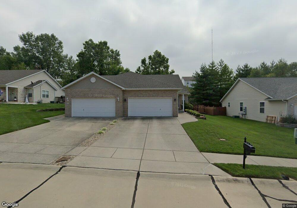
152 Rolling Oaks Dr Collinsville, IL 62234
Estimated Value: $225,000 - $241,000
4
Beds
3
Baths
1,220
Sq Ft
$191/Sq Ft
Est. Value
About This Home
This home is located at 152 Rolling Oaks Dr, Collinsville, IL 62234 and is currently estimated at $232,424, approximately $190 per square foot. 152 Rolling Oaks Dr is a home located in Madison County with nearby schools including Summit Elementary School, Dorris Intermediate School, and Collinsville Middle School.
Ownership History
Date
Name
Owned For
Owner Type
Purchase Details
Closed on
Jan 22, 2008
Sold by
Lockwood Cynthia
Bought by
Doelling Nick
Current Estimated Value
Home Financials for this Owner
Home Financials are based on the most recent Mortgage that was taken out on this home.
Original Mortgage
$116,600
Outstanding Balance
$73,639
Interest Rate
6.17%
Mortgage Type
Unknown
Estimated Equity
$158,785
Purchase Details
Closed on
Mar 25, 2005
Sold by
Call Mark R and Call Diana
Bought by
Lockwood Cynthia
Home Financials for this Owner
Home Financials are based on the most recent Mortgage that was taken out on this home.
Original Mortgage
$107,500
Interest Rate
5.64%
Mortgage Type
Unknown
Create a Home Valuation Report for This Property
The Home Valuation Report is an in-depth analysis detailing your home's value as well as a comparison with similar homes in the area
Home Values in the Area
Average Home Value in this Area
Purchase History
| Date | Buyer | Sale Price | Title Company |
|---|---|---|---|
| Doelling Nick | $146,000 | Abstracts & Titles Inc | |
| Lockwood Cynthia | $147,500 | Abstracts & Titles Inc |
Source: Public Records
Mortgage History
| Date | Status | Borrower | Loan Amount |
|---|---|---|---|
| Open | Doelling Nick | $116,600 | |
| Previous Owner | Lockwood Cynthia | $107,500 |
Source: Public Records
Tax History Compared to Growth
Tax History
| Year | Tax Paid | Tax Assessment Tax Assessment Total Assessment is a certain percentage of the fair market value that is determined by local assessors to be the total taxable value of land and additions on the property. | Land | Improvement |
|---|---|---|---|---|
| 2024 | $3,618 | $62,600 | $11,560 | $51,040 |
| 2023 | $3,618 | $57,940 | $10,700 | $47,240 |
| 2022 | $3,418 | $53,570 | $9,890 | $43,680 |
| 2021 | $3,203 | $52,370 | $9,740 | $42,630 |
| 2020 | $3,068 | $49,960 | $9,290 | $40,670 |
| 2019 | $2,973 | $48,250 | $8,970 | $39,280 |
| 2018 | $2,893 | $45,710 | $8,500 | $37,210 |
| 2017 | $2,888 | $44,800 | $8,330 | $36,470 |
| 2016 | $3,465 | $50,340 | $8,390 | $41,950 |
| 2015 | $3,221 | $49,030 | $8,170 | $40,860 |
| 2014 | $3,221 | $49,030 | $8,170 | $40,860 |
| 2013 | $3,221 | $49,030 | $8,170 | $40,860 |
Source: Public Records
Map
Nearby Homes
- 22 Brookwood Dr
- 5 Brookwood Dr
- 2007 Belt Line Rd
- 4 Delta Dr
- 1121 Carraway Ct
- 1059 Lafayette Ct Unit A
- 1035 Lafayette Ct Unit B
- 1051 Lafayette Ct Unit A
- 1224 Cedar Ridge Ct
- 123 Elliot St
- 10 White Lily Dr
- 0 Strong Ave
- 100 Debbie Dr
- 0 N Keebler Ave
- 123 W Wickliffe Ave
- 510 N Combs Ave
- 617 N Morrison Ave
- 308 Brown Ave
- 580 N Guernsey St
- 203 Greenfield Dr
- 154 Rolling Oaks Dr
- 150 Rolling Oaks Dr
- 156 Rolling Oaks Dr
- 148 Rolling Oaks Dr
- 158 Rolling Oaks Dr
- 146 Rolling Oaks Dr
- 73 Brookhill Ct
- 65 Brookhill Ct
- 144 Rolling Oaks Dr
- 160 Rolling Oaks Dr
- 81 Brookhill Ct
- 157 Rolling Oaks Dr
- 159 Rolling Oaks Dr
- 155 Rolling Oaks Dr
- 153 Rolling Oaks Dr
- 57 Brookhill Ct
- 142 Rolling Oaks Dr
- 161 Rolling Oaks Dr
- 151 Rolling Oaks Dr
- 162 Rolling Oaks Dr