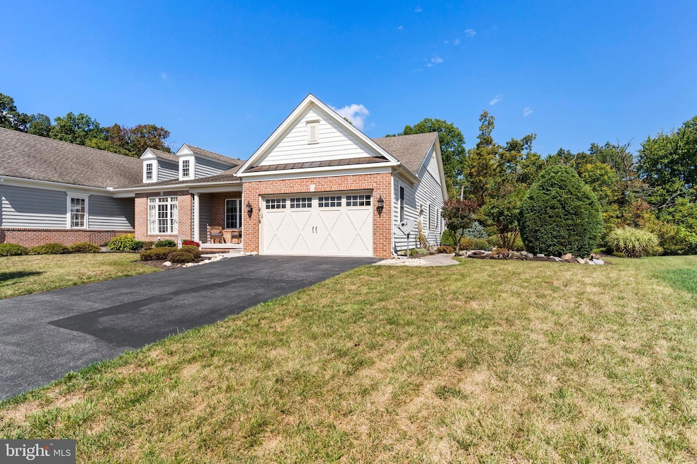
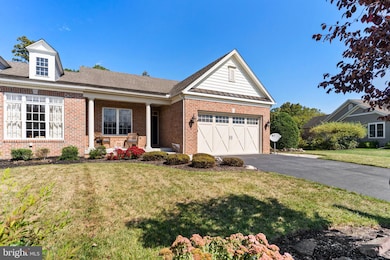
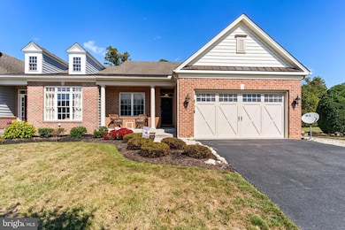
152 St Michaels Way Unit 18 Hanover, PA 17331
Estimated payment $2,725/month
Highlights
- Active Adult
- Deck
- Combination Kitchen and Living
- Colonial Architecture
- Wood Flooring
- Home Gym
About This Home
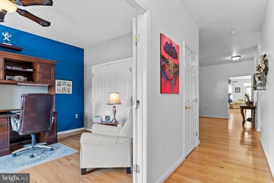
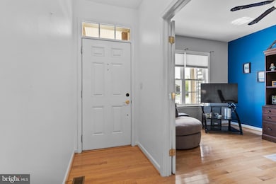
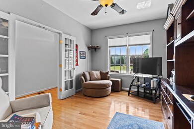
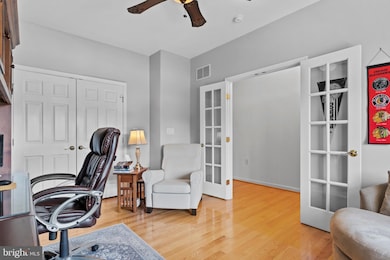
This beautifully maintained semi detached home, built in 2007, offers a perfect blend of comfort and style, with 1,950 sq. ft. of thoughtfully designed living space. Step inside to find an inviting combination kitchen and living area, ideal for both relaxation and entertaining. The family room features a cozy corner gas fireplace, creating a warm ambiance for gatherings. Enjoy meals in the formal dining room or the eat-in kitchen. The main floor laundry adds to the ease of living. Outside, the property boasts a lovely deck, patio, and porch, perfect for enjoying morning coffee or evening sunsets. With an attached garage and additional driveway parking. Community amenities include a scenic jog/walk path, encouraging an active lifestyle. The association takes care of common area maintenance.
Listing Agent
(717) 609-7619 nicolepearson@howardhanna.com Howard Hanna Company-Carlisle License #RS303587 Listed on: 09/28/2025

Townhouse Details
Home Type
- Townhome
Est. Annual Taxes
- $7,056
Year Built
- Built in 2008
HOA Fees
- $33 Monthly HOA Fees
Parking
- 2 Car Attached Garage
- 4 Driveway Spaces
- Front Facing Garage
- Garage Door Opener
- On-Street Parking
Home Design
- Semi-Detached or Twin Home
- Colonial Architecture
- Brick Exterior Construction
- Architectural Shingle Roof
- Vinyl Siding
- Concrete Perimeter Foundation
Interior Spaces
- Property has 1 Level
- Recessed Lighting
- Corner Fireplace
- Gas Fireplace
- Window Treatments
- Entrance Foyer
- Family Room Off Kitchen
- Combination Kitchen and Living
- Formal Dining Room
- Den
- Home Gym
- Eat-In Kitchen
- Wood Flooring
- Basement Fills Entire Space Under The House
- Intercom
Bedrooms and Bathrooms
- 3 Main Level Bedrooms
- En-Suite Primary Bedroom
- Walk-In Closet
- 2 Full Bathrooms
Laundry
- Laundry Room
- Laundry on main level
Accessible Home Design
- Level Entry For Accessibility
Outdoor Features
- Deck
- Patio
- Exterior Lighting
- Porch
Utilities
- Forced Air Heating and Cooling System
- Natural Gas Water Heater
Listing and Financial Details
- Tax Lot 0010
- Assessor Parcel Number 08013-0010---000
Community Details
Overview
- Active Adult
- $100 Capital Contribution Fee
- Association fees include common area maintenance
- Active Adult | Residents must be 55 or older
- Villas At Cattail Subdivision
Recreation
- Jogging Path
Map
Home Values in the Area
Average Home Value in this Area
Tax History
| Year | Tax Paid | Tax Assessment Tax Assessment Total Assessment is a certain percentage of the fair market value that is determined by local assessors to be the total taxable value of land and additions on the property. | Land | Improvement |
|---|---|---|---|---|
| 2025 | $6,930 | $289,400 | $57,000 | $232,400 |
| 2024 | $6,390 | $288,900 | $57,000 | $231,900 |
| 2023 | $6,154 | $288,900 | $57,000 | $231,900 |
| 2022 | $5,966 | $288,900 | $57,000 | $231,900 |
| 2021 | $5,813 | $288,900 | $57,000 | $231,900 |
| 2020 | $5,821 | $288,900 | $57,000 | $231,900 |
| 2019 | $5,560 | $288,900 | $57,000 | $231,900 |
| 2018 | $5,443 | $288,900 | $57,000 | $231,900 |
| 2017 | $5,219 | $288,900 | $57,000 | $231,900 |
| 2016 | -- | $288,900 | $57,000 | $231,900 |
| 2015 | -- | $288,900 | $57,000 | $231,900 |
| 2014 | -- | $288,900 | $57,000 | $231,900 |
Property History
| Date | Event | Price | List to Sale | Price per Sq Ft |
|---|---|---|---|---|
| 10/14/2025 10/14/25 | Price Changed | $400,000 | -5.9% | $185 / Sq Ft |
| 09/28/2025 09/28/25 | For Sale | $425,000 | -- | $196 / Sq Ft |
Purchase History
| Date | Type | Sale Price | Title Company |
|---|---|---|---|
| Deed | $382,000 | Apple Leaf Abstracting & Settl | |
| Deed | $307,603 | -- |
Mortgage History
| Date | Status | Loan Amount | Loan Type |
|---|---|---|---|
| Open | $286,500 | New Conventional | |
| Previous Owner | $147,537 | FHA |
Source: Bright MLS
MLS Number: PAAD2019998
APN: 08-013-0010-000
Disclaimer: Certain information contained herein is derived from information provided by parties other than Homes.com. All information provided is deemed reliable, but is not guaranteed to be accurate and should be independently verified.
![]() The data relating to real estate for sale on this website appears in part through the BRIGHT Internet Data Exchange program, a voluntary cooperative exchange of property listing data between licensed real estate brokerage firms, and is provided by BRIGHT through a licensing agreement.
The data relating to real estate for sale on this website appears in part through the BRIGHT Internet Data Exchange program, a voluntary cooperative exchange of property listing data between licensed real estate brokerage firms, and is provided by BRIGHT through a licensing agreement.
Listing information is from various brokers who participate in the Bright MLS IDX program and not all listings may be visible on the site.
The property information being provided on or through the website is for the personal, non-commercial use of consumers and such information may not be used for any purpose other than to identify prospective properties consumers may be interested in purchasing.
Some properties which appear for sale on the website may no longer be available because they are for instance, under contract, sold or are no longer being offered for sale.
Property information displayed is deemed reliable but is not guaranteed.
Copyright 2025 Bright MLS, Inc.
- 5694 Hanover Rd
- 51 Michael St Unit 6
- 40 Sandy Ct Unit 19
- 25 Eagle Ln
- 113 Flint Dr
- 105 Flint Dr
- 87 Eagle Ln
- 108 Flint Dr
- 73 Flint Dr
- 11 Flint Dr
- 15 Warm Breeze Ct Unit 96
- 24 Red Stone Ln Unit 47
- 62 Flint Dr
- 41 Buckskin
- 54 Flint Dr
- 3211 Centennial Rd
- 46 Flint Dr
- 11 Shawl Dr
- 84 Red Stone Ln Unit 41
- 92 Red Stone Ln Unit 40
- 65 North St Unit 28
- 65 North St Unit 64
- 353 Main St Unit 2
- 211 N Oxford Ave
- 700 Linden Ave Unit 700 Lower
- 607 3rd St
- 324 3rd St Unit 324-1
- 95 South St Unit 2nd floor
- 262 3rd St Unit 1st Floor and Basement
- 414 S High St Unit 2nd FL
- 142 Cypress Ln
- 203 W Clearview Rd
- 2 Clearview Ct
- 425 Carlisle St Unit 425.5 A
- 206 Carlisle St Unit 3
- 200 Carlisle St Unit C
- 432 S Franklin St
- 102 Carlisle St Unit 102B
- 119 Broadway Unit 2
- 1 E Walnut St