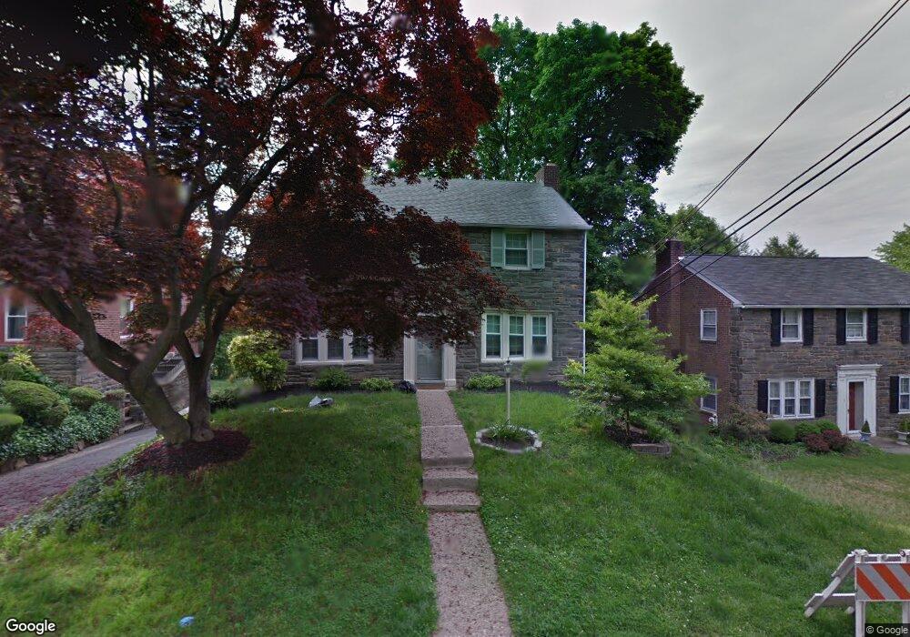
1520 Crest Rd Wynnewood, PA 19096
Estimated Value: $613,800 - $650,000
3
Beds
2
Baths
1,709
Sq Ft
$370/Sq Ft
Est. Value
About This Home
This home is located at 1520 Crest Rd, Wynnewood, PA 19096 and is currently estimated at $632,450, approximately $370 per square foot. 1520 Crest Rd is a home located in Montgomery County with nearby schools including Penn Wynne Elementary School, Bala-Cynwyd Middle School, and Lower Merion High School.
Ownership History
Date
Name
Owned For
Owner Type
Purchase Details
Closed on
Jul 3, 2007
Sold by
Nemeth Derek J
Bought by
Tannenbaum Debra B and Thomsen Lucien F
Current Estimated Value
Home Financials for this Owner
Home Financials are based on the most recent Mortgage that was taken out on this home.
Original Mortgage
$300,000
Outstanding Balance
$187,901
Interest Rate
6.54%
Estimated Equity
$444,549
Purchase Details
Closed on
Jul 14, 1995
Sold by
Schelling Curtis G and Schelling Joan R
Bought by
Hartsuch Tom A and Conroy Maureen B
Create a Home Valuation Report for This Property
The Home Valuation Report is an in-depth analysis detailing your home's value as well as a comparison with similar homes in the area
Home Values in the Area
Average Home Value in this Area
Purchase History
| Date | Buyer | Sale Price | Title Company |
|---|---|---|---|
| Tannenbaum Debra B | $400,000 | None Available | |
| Hartsuch Tom A | $138,000 | -- |
Source: Public Records
Mortgage History
| Date | Status | Borrower | Loan Amount |
|---|---|---|---|
| Open | Tannenbaum Debra B | $300,000 |
Source: Public Records
Tax History Compared to Growth
Tax History
| Year | Tax Paid | Tax Assessment Tax Assessment Total Assessment is a certain percentage of the fair market value that is determined by local assessors to be the total taxable value of land and additions on the property. | Land | Improvement |
|---|---|---|---|---|
| 2025 | $7,383 | $176,780 | $53,310 | $123,470 |
| 2024 | $7,383 | $176,780 | $53,310 | $123,470 |
| 2023 | $7,075 | $176,780 | $53,310 | $123,470 |
| 2022 | $6,944 | $176,780 | $53,310 | $123,470 |
| 2021 | $6,786 | $176,780 | $53,310 | $123,470 |
| 2020 | $6,620 | $176,780 | $53,310 | $123,470 |
| 2019 | $6,503 | $176,780 | $53,310 | $123,470 |
| 2018 | $6,503 | $176,780 | $53,310 | $123,470 |
| 2017 | $6,264 | $176,780 | $53,310 | $123,470 |
| 2016 | $6,195 | $176,780 | $53,310 | $123,470 |
| 2015 | $5,776 | $176,780 | $53,310 | $123,470 |
| 2014 | $5,776 | $176,780 | $53,310 | $123,470 |
Source: Public Records
Map
Nearby Homes
- 212 Henley Rd
- 1455 Braddock Ln
- 109 Overbrook Pkwy
- 243 Rock Glen Rd
- 758 Lawson Ave
- 755 Lawson Ave
- 26 Henley Rd
- 249 Haverford Rd
- 1504 Sheffield Ln
- 633 E Manoa Rd
- 978 Township Line Rd
- 1406 Greywall Ln
- 628 Lawson Ave
- 1319 Remington Rd
- 520 Twin Oaks Dr
- 7661 Overbrook Ave
- 529 Covington Rd
- 433 Haverford Rd
- 1848 N 76th St
- 501 E Manoa Rd
- 1518 Crest Rd
- 1015 Crest Rd
- 1516 Crest Rd
- 1014 Manoa Rd
- 1521 Manoa Rd
- 1519 Manoa Rd
- 1519 Crest Rd
- 1012 Manoa Rd
- 707 Dover Rd Unit C8
- 1514 Crest Rd
- 1011 Crest Rd
- 1517 Manoa Rd
- 220 Crosshill Rd Unit 345
- 1010 Manoa Rd
- 1512 Crest Rd
- 1515 Manoa Rd
- 1009 Crest Rd
- 709 Dover Rd
- 1513 Crest Rd
- 222 Crosshill Rd