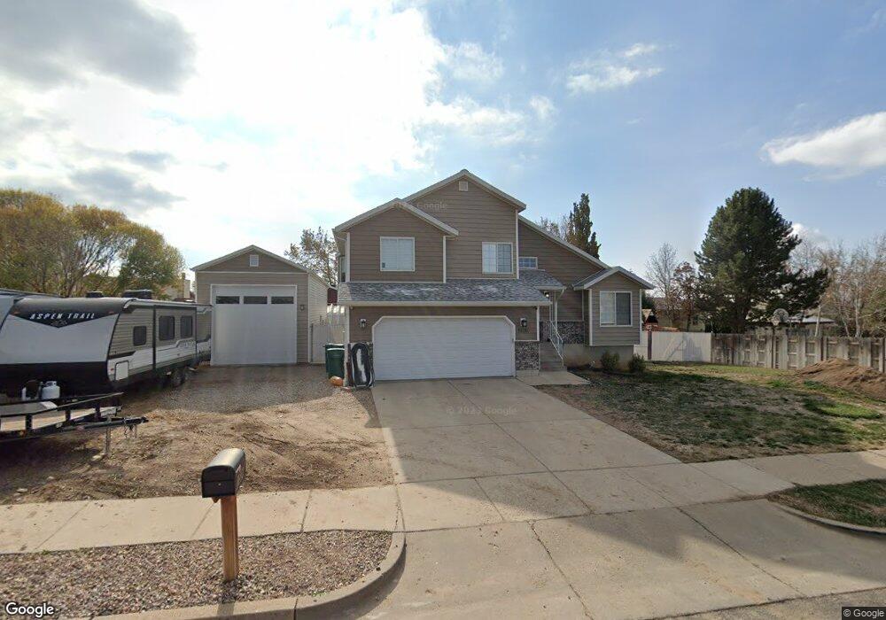
1520 E 1250 N Layton, UT 84040
Estimated Value: $500,000 - $545,000
5
Beds
3
Baths
2,148
Sq Ft
$246/Sq Ft
Est. Value
About This Home
This home is located at 1520 E 1250 N, Layton, UT 84040 and is currently estimated at $527,741, approximately $245 per square foot. 1520 E 1250 N is a home located in Davis County with nearby schools including East Layton Elementary School, Central Davis Junior High School, and Layton High School.
Ownership History
Date
Name
Owned For
Owner Type
Purchase Details
Closed on
Oct 23, 2017
Sold by
Anderson Matthew and Anderson Windy
Bought by
Doud Cody and Doud Sherry
Current Estimated Value
Purchase Details
Closed on
Sep 25, 2000
Sold by
Richeson Robert G
Bought by
Anderson Matthew and Anderson Windy
Home Financials for this Owner
Home Financials are based on the most recent Mortgage that was taken out on this home.
Original Mortgage
$143,814
Interest Rate
8.07%
Mortgage Type
FHA
Create a Home Valuation Report for This Property
The Home Valuation Report is an in-depth analysis detailing your home's value as well as a comparison with similar homes in the area
Home Values in the Area
Average Home Value in this Area
Purchase History
| Date | Buyer | Sale Price | Title Company |
|---|---|---|---|
| Doud Cody | -- | -- | |
| Anderson Matthew | -- | Associated Title Company |
Source: Public Records
Mortgage History
| Date | Status | Borrower | Loan Amount |
|---|---|---|---|
| Previous Owner | Anderson Matthew | $143,814 |
Source: Public Records
Tax History Compared to Growth
Tax History
| Year | Tax Paid | Tax Assessment Tax Assessment Total Assessment is a certain percentage of the fair market value that is determined by local assessors to be the total taxable value of land and additions on the property. | Land | Improvement |
|---|---|---|---|---|
| 2025 | $2,646 | $277,750 | $121,001 | $156,749 |
| 2024 | $2,533 | $267,850 | $145,426 | $122,424 |
| 2023 | $2,489 | $464,000 | $197,425 | $266,575 |
| 2022 | $2,516 | $254,650 | $105,780 | $148,870 |
| 2021 | $2,272 | $343,000 | $160,798 | $182,202 |
| 2020 | $2,016 | $292,000 | $129,449 | $162,551 |
| 2019 | $1,981 | $281,000 | $115,799 | $165,201 |
| 2018 | $1,798 | $256,000 | $89,564 | $166,436 |
| 2016 | $1,454 | $106,810 | $47,263 | $59,547 |
| 2015 | $1,375 | $95,920 | $47,263 | $48,657 |
| 2014 | $1,281 | $91,349 | $47,263 | $44,086 |
| 2013 | -- | $103,123 | $22,748 | $80,375 |
Source: Public Records
Map
Nearby Homes
- 1884 Nalder St
- 1281 E South Lisa St
- 1148 N 1875 E Unit 2
- 1204 N 1875 E Unit 5
- 1657 E Cherry Ln
- 1122 E 1250 N
- 1975 E 1425 N
- 1340 E Hollyhock Way
- Richards Plan at Eastridge Park - The Vistas
- Brynlee Plan at Eastridge Park - The Vistas
- Brynlee Plan at Eastridge Park - The Heights
- Ontario Plan at Eastridge Park - The Heights
- Mclauren Plan at Eastridge Park - The Vistas
- Escher Plan at Eastridge Park - The Vistas
- Rivershore Plan at Eastridge Park - The Vistas
- Helene Plan at Eastridge Park - The Vistas
- Bromley Plan at Eastridge Park - The Heights
- Beringwood Plan at Eastridge Park - The Heights
- Caulfield Plan at Eastridge Park - The Heights
- Hawthorne Plan at Eastridge Park - The Heights
- 1525 Oakridge Dr
- 1225 Cherrywood Dr
- 1493 Oakridge Dr
- 1543 Oakridge Dr
- 1477 E Oakridge Dr
- 1470 E 1250 N
- 1477 Oakridge Dr
- 1510 E Oakridge Dr
- 1222 Cherrywood Dr
- 1528 Oakridge Dr
- 1540 E Oakridge Dr
- 1512 Oakridge Dr
- 1185 Cherrywood Dr
- 1238 Cherrywood Dr
- 1551 Oakridge Dr
- 1262 N 1450 E
- 1488 Oakridge Dr
- 1453 Oakridge Dr
- 1452 E 1250 N
- 1558 Oakridge Dr