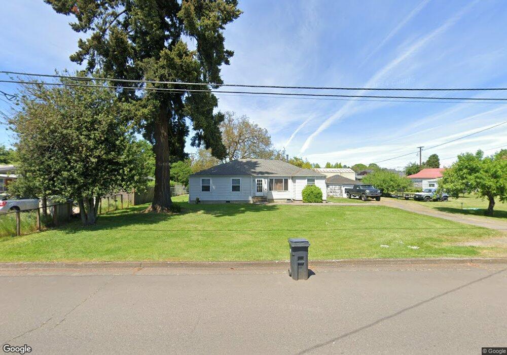
1520 W 10th Ave Junction City, OR 97448
Estimated Value: $391,465 - $436,000
3
Beds
1
Bath
1,420
Sq Ft
$292/Sq Ft
Est. Value
About This Home
This home is located at 1520 W 10th Ave, Junction City, OR 97448 and is currently estimated at $414,116, approximately $291 per square foot. 1520 W 10th Ave is a home located in Lane County with nearby schools including Junction City High School.
Ownership History
Date
Name
Owned For
Owner Type
Purchase Details
Closed on
Aug 30, 2002
Sold by
Emerald Excavating & Construction
Bought by
Toftemark & Olesen Company
Current Estimated Value
Purchase Details
Closed on
Aug 9, 1999
Sold by
Likens Danny W and Likens Joyce A
Bought by
Kvanduch Richard A and Likens Kvanduch Shawnaly E
Home Financials for this Owner
Home Financials are based on the most recent Mortgage that was taken out on this home.
Original Mortgage
$111,200
Interest Rate
7.7%
Create a Home Valuation Report for This Property
The Home Valuation Report is an in-depth analysis detailing your home's value as well as a comparison with similar homes in the area
Home Values in the Area
Average Home Value in this Area
Purchase History
| Date | Buyer | Sale Price | Title Company |
|---|---|---|---|
| Toftemark & Olesen Company | -- | -- | |
| Kvanduch Richard A | $139,000 | Western Pioneer Title Co |
Source: Public Records
Mortgage History
| Date | Status | Borrower | Loan Amount |
|---|---|---|---|
| Previous Owner | Kvanduch Richard A | $111,200 |
Source: Public Records
Tax History Compared to Growth
Tax History
| Year | Tax Paid | Tax Assessment Tax Assessment Total Assessment is a certain percentage of the fair market value that is determined by local assessors to be the total taxable value of land and additions on the property. | Land | Improvement |
|---|---|---|---|---|
| 2024 | $2,195 | $199,654 | -- | -- |
| 2023 | $2,195 | $193,839 | $0 | $0 |
| 2022 | $2,037 | $188,194 | $0 | $0 |
| 2021 | $2,006 | $182,713 | $0 | $0 |
| 2020 | $1,939 | $177,392 | $0 | $0 |
| 2019 | $1,864 | $172,226 | $0 | $0 |
| 2018 | $1,811 | $162,340 | $0 | $0 |
| 2017 | $1,742 | $162,340 | $0 | $0 |
| 2016 | $1,694 | $157,612 | $0 | $0 |
| 2015 | $1,418 | $153,021 | $0 | $0 |
| 2014 | $1,450 | $148,564 | $0 | $0 |
Source: Public Records
Map
Nearby Homes
- 1011 Rose St
- 850 Spruce St
- 847 Unity Dr
- 1225 W 10th Ave Unit 53
- 1225 W 10th Ave Unit 50
- 1225 W 10th Ave Unit 28
- 1225 W 10th Ave Unit 26
- 94403 Oaklea Dr
- 2313 W 10th Ave
- 2331 W 10th Ave
- 2347 W 10th Ave
- 2373 W 10th Ave
- 2363 W 10th Ave
- 1816 W 4th Ave
- 2384 W 9th Ave
- 2379 W 10th Ave
- 2401 W 9th Ave Unit Lot 27
- 945 W 17th Ave
- 2383 W 7th Ave
- 2393 W 7th Ave
- 1596 W 10th Ave
- 1040 Tamarack St
- 1593 W 11th Ave
- 1597 W 11th Ave
- 1525 W 11th Ave
- 1060 Tamarack St
- 1045 Spruce St
- 1025 Spruce St
- 1475 W 10th Ave
- 1598 W 10th Ave
- 1505 W 10th Ave
- 1535 W 10th Ave
- 1065 Spruce St
- 1201 W 11th Ave
- 955 Spruce St
- 982 Tamarack St
- 1594 W 11th Ave
- 997 Tamarack St
- 1105 Tamarack St
- 1150 Tamarack St