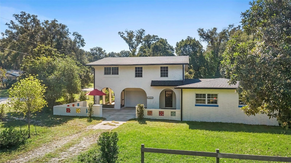
1520 W Beresford Ave Deland, FL 32720
West DeLand NeighborhoodEstimated payment $1,955/month
Highlights
- Fruit Trees
- Wood Flooring
- No HOA
- Golden High School Rated A-
- High Ceiling
- Covered Patio or Porch
About This Home
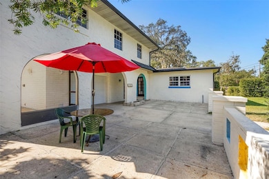
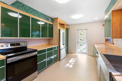
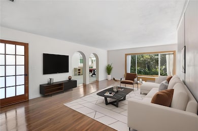
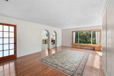
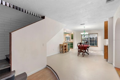
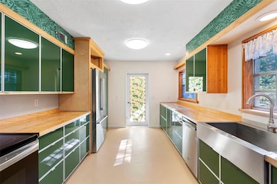
One or more photo(s) has been virtually staged. This 5-bedroom 3-bath home on Deland’s west side with classic charm features separate but attached kitchen and living areas with two bedrooms, which could be the perfect opportunity for extended family or potential rental income if local municipalities allow. Outside, the large patio area is perfect for enjoying the Florida outdoors amidst the various fruit trees that adorn this lot of over 1⁄4 acre. Inside, the main living area’s bay window and hardwood floors set the stage for the charm that is evident throughout this home. This main living area is adjacent to the secondary kitchen and private access. The large main kitchen includes all stainless-steel appliances and tons of cabinetry, providing more than ample storage for all your kitchen gadgets. The primary bedroom suite includes a large walk-in closet and ensuite bath with garden soaking tub and walk-in shower. Located under three miles from Lake Beresford Park and multiple schools, Historic Downtown Deland, shopping, restaurants, and hospitals, this quiet location on the edge of town is still located just a short hop away from everything. Ask your Realtor® for the unbranded virtual walking tour of this home. All measurements are approximate and should be independently verified.
Listing Agent
KELLER WILLIAMS HERITAGE REALTY Brokerage Phone: 407-862-9700 License #286293 Listed on: 11/07/2025

Home Details
Home Type
- Single Family
Est. Annual Taxes
- $2,294
Year Built
- Built in 1961
Lot Details
- 0.25 Acre Lot
- Lot Dimensions are 75x119
- North Facing Home
- Fruit Trees
- Property is zoned R-4
Parking
- 1 Car Attached Garage
Home Design
- Slab Foundation
- Shingle Roof
- Block Exterior
Interior Spaces
- 2,817 Sq Ft Home
- 2-Story Property
- High Ceiling
- French Doors
- Living Room
- Dining Room
- Laundry in unit
Kitchen
- Range
- Dishwasher
- Solid Wood Cabinet
Flooring
- Wood
- Concrete
- Tile
Bedrooms and Bathrooms
- 5 Bedrooms
- Primary Bedroom Upstairs
- Split Bedroom Floorplan
- Walk-In Closet
- 3 Full Bathrooms
- Soaking Tub
Outdoor Features
- Courtyard
- Covered Patio or Porch
- Rain Gutters
- Private Mailbox
Utilities
- Central Heating and Cooling System
- Well
- Septic Tank
Community Details
- No Home Owners Association
- Deland Subdivision
Listing and Financial Details
- Visit Down Payment Resource Website
- Tax Lot 40
- Assessor Parcel Number 7019-00-00-0340
Map
Home Values in the Area
Average Home Value in this Area
Tax History
| Year | Tax Paid | Tax Assessment Tax Assessment Total Assessment is a certain percentage of the fair market value that is determined by local assessors to be the total taxable value of land and additions on the property. | Land | Improvement |
|---|---|---|---|---|
| 2025 | $2,282 | $135,755 | -- | -- |
| 2024 | $2,282 | $131,930 | -- | -- |
| 2023 | $2,282 | $128,088 | $0 | $0 |
| 2022 | $2,199 | $124,357 | $0 | $0 |
| 2021 | $2,235 | $120,735 | $0 | $0 |
| 2020 | $2,193 | $119,068 | $0 | $0 |
| 2019 | $2,238 | $116,391 | $0 | $0 |
| 2018 | $2,197 | $114,221 | $0 | $0 |
| 2017 | $2,157 | $111,872 | $0 | $0 |
| 2016 | $2,048 | $109,571 | $0 | $0 |
| 2015 | $2,076 | $108,809 | $0 | $0 |
| 2014 | $2,052 | $107,945 | $0 | $0 |
Property History
| Date | Event | Price | List to Sale | Price per Sq Ft |
|---|---|---|---|---|
| 11/07/2025 11/07/25 | For Sale | $335,000 | -- | $119 / Sq Ft |
Purchase History
| Date | Type | Sale Price | Title Company |
|---|---|---|---|
| Interfamily Deed Transfer | -- | Attorney | |
| Warranty Deed | $71,000 | -- |
Mortgage History
| Date | Status | Loan Amount | Loan Type |
|---|---|---|---|
| Closed | $56,800 | Purchase Money Mortgage |
Source: Stellar MLS
MLS Number: V4945747
APN: 7019-00-00-0340
Disclaimer: Certain information contained herein is derived from information provided by parties other than Homes.com. All information provided is deemed reliable, but is not guaranteed to be accurate and should be independently verified.
![]() IDX information is provided exclusively for personal, non-commercial use, and may not be used for any purpose other than to identify prospective properties consumers may be interested in purchasing. Information is deemed reliable but not guaranteed.
IDX information is provided exclusively for personal, non-commercial use, and may not be used for any purpose other than to identify prospective properties consumers may be interested in purchasing. Information is deemed reliable but not guaranteed.
Listing Information presented by local MLS brokerage: Ten-X - (888)-952-6393
- 732 Mockingbird Ln
- 0 W Beresford Ave Unit MFRV4945851
- 0 W Beresford Ave Unit MFRV4940784
- 0 W Beresford Ave Unit MFRG5103671
- 776 Mockingbird Ln
- 1215 W Beresford Ave
- 1113 Cass St
- 1192 Happy Forest Lp
- 771 S Pearl St
- 1264 White Ash Loop
- 1186 Happy Forest Lp
- 402 Last Tree Dr
- 1212 Bear Oak Ln
- 641 Rhodes Dr
- 1159 Happy Forest Lp
- 619 Rhodes Dr
- 1201 White Ash Loop
- 1129 Blue Garden Dr
- 414 Holly Fern Trail
- 1373 Inkberry Cir
- 1370 Inkberry Cir
- 1309 Hammock Reserve Dr
- 820 W Chelsea St
- 302 S Spring Garden Ave Unit A01
- 1531 S Montgomery St
- 1523 S Boundary St
- 1575 S Montgomery St
- 139 S Stone St
- 170 E Fiesta Key Loop
- 135 S Stone St
- 647 S Delaware Ave
- 1015 Martin St
- 430 S Parsons Ave Unit 2
- 231 W Carter St Unit 7
- 231 W Carter St Unit 9
- 217 W Chelsea St
- 316 W Howry Ave Unit 4
- 510 S Florida Ave
- 320 W Howry Ave Unit 1
- 221 N Adelle Ave